


 |
市場調查報告書
商品編碼
2119645
澳新銀行地理空間分析:市場佔有率分析、產業趨勢與統計、成長預測(2026-2031 年)ANZ Geospatial Analytics - Market Share Analysis, Industry Trends & Statistics, Growth Forecasts (2026 - 2031) |
||||||

※ 本網頁內容可能與最新版本有所差異。詳細情況請與我們聯繫。
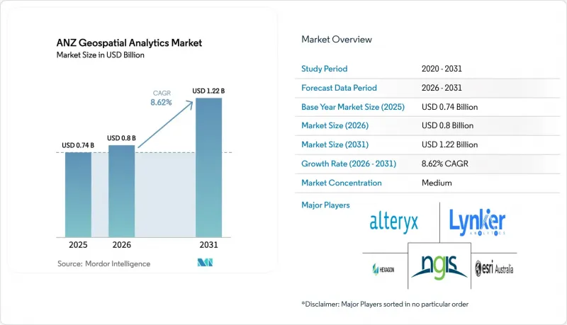
根據 Mordor Intelligence 預測,紐澳地區的地理空間分析市場規模將從 2025 年的 7.4 億美元成長到 2026 年的 8 億美元,然後在 2031 年達到 12.2 億美元,2026 年至 2031 年的複合年成長率為 8.62%。
本報告按類型(表面分析、網路分析、地理視覺化)、最終用戶產業(農業、公共產業與通訊、國防與資訊、政府、採礦與自然資源、汽車與運輸、醫療保健、房地產與建築等)以及國家進行細分。市場預測以美元(USD)計價。
澳新銀行地理空間分析市場趨勢與洞察
人工智慧/機器學習的引入正在加速地理資訊系統(GIS)的主流化進程。
目前,人工智慧 (AI) 和機器學習 (ML) 正在為澳洲和紐西蘭 (ANZ) 地理空間分析市場的關鍵 GIS 工作流程提供支撐,從而減少人工處理時間並支援即時決策。必和必拓 (BHP) 的數位孿生技術已節省超過 3 吉升水和 118 吉瓦時能源,凸顯了其在永續發展方面取得的實際成就。預計 2024 年至 2029 年間,全球地理空間人工智慧 (GeoAI) 收入將成長四倍,這一前景正推動平台供應商整合預訓練模型和無程式碼 AI 流程。大學也在推動這一趨勢。雪梨大學的土壤濕度工具整合了解析度為 80 平方米的衛星圖像和感測器數據,用於最佳化灌溉計畫。
智慧城市和數位孿生項目正在推動基礎設施投資。
維多利亞州和新南威爾斯州的州級計畫已撥款超過7,700萬美元,用於建造身臨其境型4D模型,以輔助交通規劃和災害管理。惠靈頓的數位孿生模型將交通流量、空中交通模式和物聯網感測器資料疊加在一起,使官員在施工開始前直覺地了解提案橋樑的影響。私人開發商也從中受益。據Lendlease公司稱,數位孿生模型可以指導進度安排決策,預計將降低20%的成本,並將產品上市時間縮短100倍。
平台和資料許可的高成本阻礙了中小企業 (SME) 的採用。
企業級GIS套件對小規模承包商和市政機構而言是一道門檻,其初始許可費超過11,500美元,年度訂閱費超過3,800美元。雲端託管會根據儲存空間和頻寬產生不同的額外費用,這使得預算規劃變得困難,並且常常導致概念驗證(PoC)先導計畫停滯不前。 Euclideon的訂閱式3D資料中心是競爭對手的回應,它透過捆綁免費檢視器降低了進入門檻。然而,在價格透明度提高之前,許多中小企業都在推遲全面採用數位孿生技術,這正在減緩紐澳地區地理空間分析市場的短期成長。
細分市場分析
到 2025 年,解決方案將佔據最大的市場佔有率,達到 62.40%。這主要得益於對成熟平台的投資,這些平台支援日常地圖繪製、資產追蹤和監管報告。同時,託管服務正以 16.9% 的複合年成長率成長。這是因為企業越來越傾向於可預測的營運支出 (OPEX) 而非永久許可,並且意識到外包可以彌補人才短缺。 Esri Australia 的雲端託管 GIS 就是這種模式的典型例子,它提供符合 SOC2 標準的安全性以及本地服務台支持,使內部團隊擺脫了日常的修補程式和擴展性管理工作。
服務供應商如今正將持續最佳化、DevOps 管線和培訓打包成服務,從專案承包商轉型為主導數位孿生藍圖的策略合作夥伴。這一趨勢正將競爭優勢轉移到擁有多元化人才(資料科學家、使用者體驗設計師、領域顧問等)的公司,這些公司能夠將分散的資料集整合到整合的決策支援引擎中。因此,市場正在加速從解決方案所有權向基於訂閱的生態系統轉變,Trimble 的軟體收入也構成比了這一趨勢,其軟體收入佔總收入的 75%,並創造了 22.6 億美元的年度經常性收入。
即使到了2025年,本地部署仍維持47.10%的收入佔有率。這主要歸功於採礦、國防和公共產業等行業對高度敏感地理數據的自願管理給予了高度重視。然而,雲端領域的複合年成長率達到21%,顯示人們對超大規模環境的容錯性和成本彈性越來越有信心。 ArcGIS Online 99.9%的運轉率保證,以及其跨多重雲端環境的可攜性,對於那些希望在不建構冗餘資料中心的情況下實現跨轄區協作的組織來說極具吸引力。
混合部署兼顧風險與敏捷性,使企業能夠將工作負載容器化,以便在需要時將資料突發到雲端,用於人工智慧訓練和Terabyte級渲染,同時將最關鍵的層保留在本地。政府光纖網路的部署以及SouthPAN精度的提升進一步緩解了延遲限制,使得透過公共網路傳輸高解析度高程模型和即時無人機影像成為可能。因此,我們看到市場正在發生架構轉變。雲端原生微服務將負責資料擷取、分析和視覺化流程,而傳統的本地叢集將承擔資料暫存區和資料主權儲存庫的角色。
其他好處:
- Excel格式的市場預測(ME)表
- 3個月的分析師支持
目錄
第1章:引言
- 研究假設和市場定義
- 調查範圍
第2章:調查方法
第3章執行摘要
第4章 市場狀況
- 市場概覽
- 市場促進因素
- 智慧城市和數位孿生計畫的推進,帶動了市場需求的成長。
- 將人工智慧/機器學習引入主流GIS工作流程
- 新冠疫情後的基礎設施獎勵策略正在促進地理空間領域的資本投資。
- 採礦和農業空間數據報告義務
- 精密農業中田間決策支援的需求
- 利用地球觀測資料檢驗碳權額度
- 市場限制因素
- 高昂的平台和數據許可成本
- 澳洲和紐西蘭之間沒有統一的空間資料標準。
- 地理空間資料科學領域人才短缺
- 輿論反彈
- 價值鏈分析
- 監理情勢
- 技術展望
- 雲端原生地理人工智慧管道
- 波特五力模型
第5章 市場規模與成長預測
- 按組件
- 解決方案
- 服務
- 按部署模式
- 現場
- 雲
- 混合
- 透過分析方法
- 說明的
- 預測
- 處方
- 按類型
- 地面分析
- 網路分析
- 地理視覺化
- 按最終用戶行業分類
- 農業
- 公共產業及通訊
- 國防與資訊
- 政府
- 採礦和自然資源
- 汽車和交通運輸
- 醫療保健
- 房地產和建築
- 其他
- 國家
- 澳洲
- 紐西蘭
第6章 競爭情勢
- 市場集中度
- 策略趨勢
- 市佔率分析
- 公司簡介
- Esri Australia Pty Ltd
- NGIS Australia Pty Ltd
- Hexagon AB
- Alteryx Inc.
- Lynker Analytics Ltd
- Intermap Technologies Corp.
- Mapizy Pty Ltd
- CoreLogic NZ Ltd
- Abley Ltd
- Geospatial Intelligence Pty Ltd
- Digital Agriculture Services Pty Ltd
- SRA Information Technology Pty Ltd
- Fugro NV
- Nearmap Ltd
- Trimble Inc.
- Maxar Technologies Inc.
- Google Australia Pty Ltd(Google Cloud Geo)
- Jacobs Group(Australia)Pty Ltd
- Woolpert Australia Pty Ltd
- FrontierSI Ltd
第7章 市場機會與未來展望
第8章 投資分析
According to Mordor Intelligence, the ANZ geospatial analytics market size is expected to grow from USD 0.74 billion in 2025 to USD 0.8 billion in 2026 and is forecast to reach USD 1.22 billion by 2031 at 8.62% CAGR over 2026-2031.
This report is Segmented by Type (Surface Analysis, Network Analysis, Geovisualization), by End-User Vertical (Agriculture, Utility and Communication, Defense and Intelligence, Government, Mining and Natural Resources, Automotive and Transportation, Healthcare, Real Estate and Construction, Other End-User Verticals), and by Country. The Market Forecasts are Provided in Terms of Value (USD).
ANZ Geospatial Analytics Market Trends and Insights
AI/ML Infusion Accelerates Mainstream GIS Adoption
Artificial intelligence and machine learning now underpin core GIS workflows across the ANZ geospatial analytics market, reducing manual processing times and enabling real-time decision support. BHP's digital twins conserve more than 3 gigaliters of water and 118 GWh of energy, highlighting tangible sustainability outcomes. GeoAI revenue is forecast to quadruple globally between 2024 and 2029, an outlook that encourages platform vendors to embed pre-trained models and no-code AI pipelines. Universities bolster this trend; the University of Sydney's soil-moisture tool merges satellite imagery with sensor feeds at 80 m2 resolution to fine-tune irrigation scheduling. Natural-language GIS copilots are appearing, letting planners pose queries such as "Highlight parcels with flood risk above
Smart-City and Digital-Twin Programs Drive Infrastructure Investment
State-level programs in Victoria and New South Wales allocate more than USD 77 million to create immersive 4D models for transport planning and hazard management. Wellington's Digital Twin layers traffic counts, air-traffic patterns, and IoT sensor data so officials can visualize the effect of proposed bridges before construction. Private developers also gain; Lendlease reports potential 20% cost savings and 100-fold speed-to-market improvements when digital twins guide scheduling decisions.
High Platform and Data Licensing Costs Constrain SME Adoption
Enterprise-grade GIS suites command initial license fees exceeding USD 11,500 plus annual subscriptions above USD 3,800, a hurdle for small contractors and councils . Cloud hosting adds variable storage and bandwidth surcharges that make budgeting unpredictable, often stalling proof-of-concept pilots. Competitive responses include Euclideon's subscription-based 3D data hub that bundles free viewers to lower entry frictio. Yet until price transparency improves, many SMEs postpone full digital-twin rollouts, tempering near-term expansion of the ANZ geospatial analytics market.
Other drivers and restraints analyzed in the detailed report include:
- Post-COVID Infrastructure Stimulus Fuels Geospatial Capital Expenditure
- Mandatory Spatial-Data Reporting Transforms Compliance Workflows
- Shortfall of Geospatial Data-Science Talent Threatens Growth
For complete list of drivers and restraints, kindly check the Table Of Contents.
Segment Analysis
Solutions generated the largest slice of the ANZ geospatial analytics market in 2025 at 62.40%, buoyed by entrenched platform investments that underpin day-to-day mapping, asset tracking, and regulatory reporting. Managed services, however, are climbing at 16.9% CAGR because organizations favor predictable OPEX over perpetual licenses and recognize that outsourcing bridges the talent shortfall. Esri Australia's cloud-hosted managed GIS exemplifies the model, offering SOC2-aligned security plus local help-desk support that frees internal teams from routine patching and scalability chores.
Service vendors now bundle continuous optimization, DevOps pipelines, and training, transforming from project contractors into strategic partners that shepherd digital-twin roadmaps. This dynamic shifts competitive advantage toward firms with multidisciplinary benches data scientists, UX designers, and domain consultants who knit disparate datasets into cohesive decision-support engines. As a result, the ANZ geospatial analytics market sees accelerating migration from solution ownership toward subscription-based ecosystems, a trend reinforced by Trimble's 75% software revenue mix and USD 2.26 billion in annualized recurring revenue.
On-premise installations retained 47.10% revenue in 2025 because mining, defense, and utilities prioritize sovereign control over sensitive geodata. Yet the cloud segment's 21% CAGR underscores growing confidence in hyperscale resilience and cost elasticity. ArcGIS Online's 99.9% uptime pledge, paired with multicloud portability, appeals to agencies seeking cross-jurisdiction collaboration without building redundant data centers.
Hybrid deployments bridge risk and agility, letting organizations containerize workloads that burst to the cloud for AI training or terabyte-scale rendering while retaining crown-jewel layers on site. Government fiber rollouts and SouthPAN accuracy upgrades further erode latency constraints, making it feasible to stream high-resolution elevation models or live drone feeds over public networks. Consequently, the ANZ geospatial analytics market observes an architectural pivot: cloud-native micro-services handle ingest, analytics, and visualization pipelines, whereas legacy on-prem clusters become staging areas or data-sovereignty vaults.
Complete Report Scope:
- By Component
- Solutions
- Services
- By Deployment Model
- On-premise
- Cloud
- Hybrid
- By Analytics Technique
- Descriptive
- Predictive
- Prescriptive
- By Type
- Surface Analysis
- Network Analysis
- Geovisualization
- By End-user Vertical
- Agriculture
- Utility and Communication
- Defense and Intelligence
- Government
- Mining and Natural Resources
- Automotive and Transportation
- Healthcare
- Real-Estate and Construction
- Other Verticals
- By Country
- Australia
- New Zealand
List of Companies Covered in this Report:
- Esri Australia Pty Ltd
- NGIS Australia Pty Ltd
- Hexagon AB
- Alteryx Inc.
- Lynker Analytics Ltd
- Intermap Technologies Corp.
- Mapizy Pty Ltd
- CoreLogic NZ Ltd
- Abley Ltd
- Geospatial Intelligence Pty Ltd
- Digital Agriculture Services Pty Ltd
- SRA Information Technology Pty Ltd
- Fugro NV
- Nearmap Ltd
- Trimble Inc.
- Maxar Technologies Inc.
- Google Australia Pty Ltd (Google Cloud Geo)
- Jacobs Group (Australia) Pty Ltd
- Woolpert Australia Pty Ltd
- FrontierSI Ltd
Additional Benefits:
- The market estimate (ME) sheet in Excel format
- 3 months of analyst support
TABLE OF CONTENTS
1 INTRODUCTION
- 1.1 Study Assumptions and Market Definition
- 1.2 Scope of the Study
2 RESEARCH METHODOLOGY
3 EXECUTIVE SUMMARY
4 MARKET LANDSCAPE
- 4.1 Market Overview
- 4.2 Market Drivers
- 4.2.1 Growing demand from smart-city and digital-twin programs
- 4.2.2 AI/ML infusion into mainstream GIS workflows
- 4.2.3 Post-COVID infrastructure stimulus fuelling geospatial capex
- 4.2.4 Mandatory spatial-data reporting in mining and agriculture
- 4.2.5 Precision-ag ''paddock-level'' decision support requirements
- 4.2.6 Carbon-credit verification using earth-observation datasets
- 4.3 Market Restraints
- 4.3.1 High platform and data licensing costs
- 4.3.2 Fragmented spatial-data standards between AU and NZ
- 4.3.3 Shortfall of geospatial data-science talent
- 4.3.4 Public backlash over location-privacy breaches
- 4.4 Value Chain Analysis
- 4.5 Regulatory Landscape
- 4.6 Technological Outlook
- 4.6.1 Cloud-Native GeoAI Pipelines
- 4.7 Porter's Five Forces
- 4.7.1 Bargaining Power of Buyers
- 4.7.2 Bargaining Power of Suppliers
- 4.7.3 Threat of New Entrants
- 4.7.4 Threat of Substitutes
- 4.7.5 Intensity of Competitive Rivalry
5 MARKET SIZE AND GROWTH FORECASTS (VALUE)
- 5.1 By Component
- 5.1.1 Solutions
- 5.1.2 Services
- 5.2 By Deployment Model
- 5.2.1 On-premise
- 5.2.2 Cloud
- 5.2.3 Hybrid
- 5.3 By Analytics Technique
- 5.3.1 Descriptive
- 5.3.2 Predictive
- 5.3.3 Prescriptive
- 5.4 By Type
- 5.4.1 Surface Analysis
- 5.4.2 Network Analysis
- 5.4.3 Geovisualization
- 5.5 By End-user Vertical
- 5.5.1 Agriculture
- 5.5.2 Utility and Communication
- 5.5.3 Defense and Intelligence
- 5.5.4 Government
- 5.5.5 Mining and Natural Resources
- 5.5.6 Automotive and Transportation
- 5.5.7 Healthcare
- 5.5.8 Real-Estate and Construction
- 5.5.9 Other Verticals
- 5.6 By Country
- 5.6.1 Australia
- 5.6.2 New Zealand
6 COMPETITIVE LANDSCAPE
- 6.1 Market Concentration
- 6.2 Strategic Moves
- 6.3 Market Share Analysis
- 6.4 Company Profiles (includes Global level overview, Market level overview, Core segments, Financials as available, Strategic information, Market Rank/Share, Products & Services, Recent Developments)
- 6.4.1 Esri Australia Pty Ltd
- 6.4.2 NGIS Australia Pty Ltd
- 6.4.3 Hexagon AB
- 6.4.4 Alteryx Inc.
- 6.4.5 Lynker Analytics Ltd
- 6.4.6 Intermap Technologies Corp.
- 6.4.7 Mapizy Pty Ltd
- 6.4.8 CoreLogic NZ Ltd
- 6.4.9 Abley Ltd
- 6.4.10 Geospatial Intelligence Pty Ltd
- 6.4.11 Digital Agriculture Services Pty Ltd
- 6.4.12 SRA Information Technology Pty Ltd
- 6.4.13 Fugro NV
- 6.4.14 Nearmap Ltd
- 6.4.15 Trimble Inc.
- 6.4.16 Maxar Technologies Inc.
- 6.4.17 Google Australia Pty Ltd (Google Cloud Geo)
- 6.4.18 Jacobs Group (Australia) Pty Ltd
- 6.4.19 Woolpert Australia Pty Ltd
- 6.4.20 FrontierSI Ltd
7 Market Opportunities and Future Outlook
- 7.1 White-space and Unmet-need Assessment
8 Investment Analysis

 中東地理空間分析:市場佔有率分析、產業趨勢與統計、成長預測(2026-2031)法國地理分析:市場佔有率分析、產業趨勢與統計、成長預測(2026-2031)東協地理空間分析:市場佔有率分析、產業趨勢與統計及成長預測(2026-2031)地理空間分析:市場佔有率分析、產業趨勢與統計、成長預測(2026-2031)
 地理空間分析市場:2026-2032年全球市場預測(依組件、技術、資料類型、部署模式、組織規模及應用分類)印度地理空間分析:市場佔有率分析、產業趨勢與統計、成長預測(2026-2031)
 2026-2030年全球地理空間分析市場
 地理空間分析市場規模、佔有率和趨勢分析報告:按組件、類型、應用、地區和細分市場預測(2026-2033 年)
 地理空間分析市場規模、佔有率和成長分析:按組件、分析類型、部署模式、最終用戶產業和地區分類-2026-2033年產業預測
 地理空間分析市場報告:按組件、類型、技術、企業規模、部署模式、產業和地區分類(2026-2034 年)