


 |
市場調查報告書
商品編碼
2119617
東協地理空間分析:市場佔有率分析、產業趨勢與統計及成長預測(2026-2031)ASEAN Geospatial Analytics - Market Share Analysis, Industry Trends & Statistics, Growth Forecasts (2026 - 2031) |
||||||

※ 本網頁內容可能與最新版本有所差異。詳細情況請與我們聯繫。
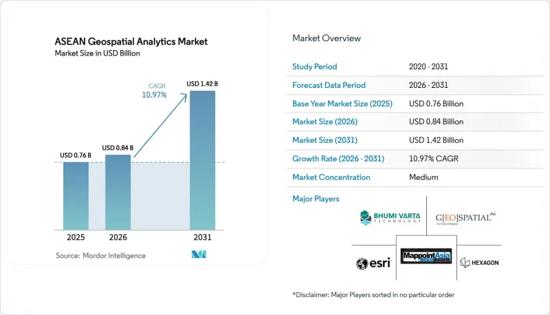
根據 Mordor Intelligence 預測,東協地理空間分析市場規模將從 2025 年的 7.6 億美元成長到 2026 年的 8.4 億美元,然後在 2031 年達到 14.2 億美元,2026 年至 2031 年的複合年成長率為 10.97%。
本報告按元件(軟體、服務、硬體)、類型(表面分析、網路分析等)、最終用戶產業(政府/公共安全、國防/情報機構等)、部署模式(本地部署、雲端部署、邊緣/混合部署)、技術(GIS、GPS、遙感探測等)和地區進行細分。市場預測以價值(美元)表示。
東協地理空間分析市場趨勢與洞察
東協各國首都正大力投資建設智慧城市。
各市政府正將地理空間儀錶板作為其城市管理中心的核心。雅加達的綜合空間入口網站預計到2025年可將緊急應變時間縮短18%。泰國東部經濟走廊已累計1.5兆泰銖(約429億美元),用於在2027年前開展需要使用雷射雷達產生的數位孿生進行施工前影響評估的專案。河內已批准12億美元的預算,用於其3D數位孿生計劃,以指導區域規劃修訂。東協智慧城市網路發布了2025年互通性指南,其中引用了OGC WMS和舉措 ,從而降低了供應商之間的整合成本。印尼新首都努桑塔拉(Nusantara)是一個耗資330億美元的項目,在建設的每個階段都採用了基於無人機的攝影測量技術。
5G 的快速部署使得利用高容量、低延遲的位置資訊成為可能。
新加坡已建成覆蓋全國的5G網路,延遲低於10毫秒,使建設公司能夠即時傳輸雷射雷達點雲數據。馬來西亞計劃在2024年12月前實現5G網路覆蓋80%的人口,屆時吉隆坡將能夠利用地理圍欄技術最佳化車輛行駛。泰國於2024年拍賣了26GHz頻段,目前正在支持一項精密農業試點項目,將減少12%的農藥使用。越南為工業園區的5G基地台提供補貼,實現無需Wi-Fi的無人機庫存盤點。菲律賓已強制要求在易受災害影響的城市部署5G網路,以便在颱風過後快速上傳無人機拍攝的影像。
即時分析所需的高效能GPU或CPU的成本
在Google地球引擎中運行一次區域土地覆蓋分析需要花費 200 美元,這幾乎相當於柬埔寨普通市政當局 IT 預算的一半。一張 NVIDIA A100 顯示卡的零售價為 1 萬美元,而一個基本的 16 GPU叢集的成本超過 20 萬美元。政府使用調查顯示,GPU 使用率僅為 42%,這意味著各機構為閒置的 GPU 資源支付了過高的費用。雖然租用 V100 等雲端 GPU 執行個體可以降低資本支出 (Capex),但持續的費用仍然會給多年的預算帶來沉重負擔。
細分市場分析
服務業正以12.41%的複合年成長率快速擴張,超越軟體業的主導地位。預計到2025年,軟體業將佔據東協地理空間分析市場52.46%的佔有率。缺乏內部專業技術的企業正在將雷射雷達測量、衛星影像預處理和客製化模型建置等工作外包。 Esri泰國公司預計到2025年,其專業服務訂單將成長23%。硬體對於資料擷取仍然至關重要,Trimble公司的Catalyst DA2能夠為智慧型手機帶來分米級的精確度。
諸如PostGIS和Oracle Spatial之類的雲端原生空間引擎能夠在高峰期實現彈性擴展。 Hexagon的BLK2FLY無人機透過將即時物件分類與自動雲端上傳結合,可後處理時間縮短40%。隨著供應商擴大將硬體租賃、雲端運算和專業服務捆綁在基於結果的合約中,東協地理空間分析市場中這些組成部分之間的界限正變得日益模糊。
空間人工智慧和預測建模正以13.17%的複合年成長率快速成長,迅速縮小與地面分析的差距。預計到2025年,地面分析將佔東協地理空間分析市場規模的38.26%。菲律賓航太局利用基於Planet衛星影像訓練的捲積神經網路(CNN)在偵測不規則居住方面實現了92%的準確率。 HERE Technologies公司報告稱,透過將即時交通資訊整合到雅加達的物流路線中,配送時間縮短了11%。
儘管地表分析在洪水建模和邊坡穩定性評估等領域仍佔據主導地位,但長期氣象資料的整合正推動靜態地形模型向季節性模擬演進。在馬來西亞,網路分析正指南電力公司確定變電站的位置。地理空間視覺化正邁入擴增實境(AR)領域,使新加坡的城市負責人能夠將建築輪廓疊加到施工現場。在東協地理空間分析市場,預測性人工智慧正根據盜獵預測熱力圖提案野生動物巡邏路線。
其他好處:
- Excel格式的市場預測(ME)表
- 3個月的分析師支持
目錄
第1章:引言
- 研究假設和市場定義
- 調查範圍
第2章:調查方法
第3章執行摘要
第4章 市場狀況
- 市場概覽
- 市場促進因素
- 東協各國首都正大力投資建設智慧城市。
- 5G的快速普及將使高容量、低延遲的位置資料成為可能。
- 國家地理空間資料共用的強制性要求(例如,泰國的GISTDA)
- 地理空間監測正透過與環境、社會和治理 (ESG) 相關的基礎建設資金籌措而受到關注。
- 人工智慧衛星星系顯著縮短了影像刷新周期。
- 地方政府科技平台正在推動地方分析生態系統的復興。
- 市場限制因素
- 即時分析中高效能GPU/CPU的成本
- 東協成員國空間資料標準存在差異
- 特定領域地理空間資料科學家短缺
- 加強資料主權方面的監管正在限制跨境資料集。
- 宏觀經濟因素對市場的影響
- 產業價值鏈分析
- 監理情勢
- 波特五力分析
第5章 市場規模與成長預測
- 按組件
- 軟體
- 服務
- 硬體
- 按類型
- 地面分析
- 網路分析
- 地理視覺化
- 空間人工智慧與預測建模
- 按最終用戶行業分類
- 政府/公共安全
- 國防和情報機構
- 公共產業及通訊
- 農業
- 採礦和自然資源
- 房地產和建築
- 衛生保健
- 汽車和交通運輸
- 其他
- 按實現類型
- 現場
- 雲
- 邊緣/混合
- 透過技術
- GIS
- GPS
- 遙感探測
- LiDAR
- 網路地圖服務和應用程式介面
- 國家
- 汶萊
- 柬埔寨
- 印尼
- 寮國
- 馬來西亞
- 緬甸
- 菲律賓
- 新加坡
- 泰國
- 越南
第6章 競爭情勢
- 市場集中度
- 策略趨勢
- 市佔率分析
- 公司簡介
- Hexagon AB
- Esri(Thailand)Co., Ltd.
- MappointAsia(Thailand)PCL
- PT Bhumi Varta Technology
- Geospatial AI Sdn Bhd(Uzma Berhad)
- GIS Co., Ltd.
- Intermap Technologies
- Mandalay Technology Co., Ltd.
- Spatialworks Sdn Bhd
- SkyMap Global
- Trimble Inc.
- HERE Technologies
- Maxar Technologies
- Planet Labs PBC
- SuperMap Software Co.
- Google Cloud Geo-Spatial
- Mapbox Inc.
- Alteryx Inc.
- Oracle Spatial
- Fugro NV
- Satelligence BV
第7章 市場機會與未來展望
According to Mordor Intelligence, the ASEAN geospatial analytics market size is expected to grow from USD 0.76 billion in 2025 to USD 0.84 billion in 2026 and is forecast to reach USD 1.42 billion by 2031 at 10.97% CAGR over 2026-2031.
This report is Segmented by Component (Software, Services, and Hardware), Type (Surface Analysis, Network Analysis, and More), End-User Vertical (Government and Public Safety, Defense and Intelligence, and More), Deployment Mode (On-Premise, Cloud, and Edge/Hybrid), Technology (GIS, GPS, Remote Sensing, and More), and Geography. The Market Forecasts are Provided in Terms of Value (USD).
ASEAN Geospatial Analytics Market Trends and Insights
Smart-city Investment Surge Across ASEAN Capitals
Municipal governments are placing geospatial dashboards at the core of city-operations centers. Jakarta's unified spatial portal reduced emergency-response times by 18% in 2025. Thailand's Eastern Economic Corridor earmarked THB 1.5 trillion (USD 42.9 billion) through 2027 for projects that must run pre-build impact assessments using LiDAR-derived digital twins. Hanoi approved USD 1.2 billion for a 3D digital-twin initiative that guides zoning revisions. The ASEAN Smart Cities Network issued 2025 interoperability guidance that references OGC WMS and GeoJSON, lowering vendor integration costs. Indonesia's USD 33 billion Nusantara capital builds drone-based photogrammetry into every construction phase.
Rapid 5G Roll-out Unlocking High-volume, Low-latency Location Data
Completed nationwide 5G coverage in Singapore delivers sub-10 millisecond latency, letting construction firms stream LiDAR point clouds in real time. Malaysia reached 80% population coverage by December 2024, enabling geofenced fleet optimization in Kuala Lumpur. Thailand auctioned 26 GHz spectrum in 2024 and now supports precision-agriculture pilots that cut pesticide use by 12%. Vietnam subsidized 5G base stations in industrial parks where drones audit inventory without Wi-Fi dependencies. The Philippines mandates 5G in disaster-prone municipalities by 2026, supporting rapid drone imagery uploads after typhoons.
High-performance GPU or CPU Costs for Real-time Analytics
A single regional land-cover run on Google Earth Engine can cost USD 200, consuming nearly half of an average Cambodian municipal IT budget. An NVIDIA A100 unit retails at USD 10,000, pushing a basic 16-GPU cluster beyond USD 200,000. Government utilization studies show only 42% GPU use, meaning agencies overpay for idle capacity. While cloud GPU rentals like V100 instances lower capex, recurring bills still strain multi-year budgets.
Other drivers and restraints analyzed in the detailed report include:
- National Geospatial Data-sharing Mandates
- AI-ready Satellite Constellations Slashing Image Refresh Cycles
- Fragmented Spatial Data Standards Among ASEAN Member States
For complete list of drivers and restraints, kindly check the Table Of Contents.
Segment Analysis
Services expanded at a 12.41% CAGR, eclipsing the dominance software maintained with a 52.46% ASEAN Geospatial Analytics market share in 2025. Agencies lacking in-house talent are outsourcing LiDAR flights, satellite-image preprocessing, and custom model-building. Esri Thailand recorded a 23% jump in professional-services bookings during 2025. Hardware remains essential for data capture, with Trimble's Catalyst DA2 bringing decimeter accuracy to smartphones.
Cloud-native spatial engines such as PostGIS and Oracle Spatial permit elastic scaling during seasonal peaks. Hexagon's BLK2FLY drone pairs real-time object classification with automated cloud uploads, trimming post-processing by 40%. Vendors increasingly bundle hardware leasing, cloud compute, and professional services under outcome-linked contracts, blurring component boundaries inside the ASEAN Geospatial Analytics market.
Spatial AI and predictive modeling are growing at a 13.17% CAGR, rapidly narrowing the gap with surface analysis, which held 38.26% of ASEAN Geospatial Analytics market size in 2025. The Philippine Space Agency achieved 92% accuracy detecting informal settlements via a CNN trained on Planet imagery. HERE Technologies reported 11% delivery-time reductions after embedding real-time traffic into Jakarta logistics routes.
Surface analysis still dominates flood modeling and slope stability, but integration of long-range weather data is turning static terrain models into seasonal simulations. Network analysis now guides electric-utility substation placement in Malaysia. Geo-visualization has leaped into augmented reality, letting Singapore planners superimpose building envelopes on active construction sites. Across ASEAN Geospatial Analytics market deployments, prescriptive AI is advising wildlife-patrol routes based on predictive poaching heatmaps.
Complete Report Scope:
- By Component
- Software
- Services
- Hardware
- By Type
- Surface Analysis
- Network Analysis
- Geo-visualization
- Spatial AI and Predictive Modelling
- By End-user Vertical
- Government and Public Safety
- Defense and Intelligence
- Utilities and Telecom
- Agriculture
- Mining and Natural Resources
- Real Estate and Construction
- Healthcare
- Automotive and Transportation
- Other End-user Verticals
- By Deployment Mode
- On-premise
- Cloud
- Edge / Hybrid
- By Technology
- GIS
- GPS
- Remote Sensing
- LiDAR
- Web Map Services and APIs
- By Country
- Brunei
- Cambodia
- Indonesia
- Laos
- Malaysia
- Myanmar
- Philippines
- Singapore
- Thailand
- Vietnam
List of Companies Covered in this Report:
- Hexagon AB
- Esri (Thailand) Co., Ltd.
- MappointAsia (Thailand) PCL
- PT Bhumi Varta Technology
- Geospatial AI Sdn Bhd (Uzma Berhad)
- GIS Co., Ltd.
- Intermap Technologies
- Mandalay Technology Co., Ltd.
- Spatialworks Sdn Bhd
- SkyMap Global
- Trimble Inc.
- HERE Technologies
- Maxar Technologies
- Planet Labs PBC
- SuperMap Software Co.
- Google Cloud Geo-Spatial
- Mapbox Inc.
- Alteryx Inc.
- Oracle Spatial
- Fugro N.V.
- Satelligence B.V.
Additional Benefits:
- The market estimate (ME) sheet in Excel format
- 3 months of analyst support
TABLE OF CONTENTS
1 INTRODUCTION
- 1.1 Study Assumptions and Market Definition
- 1.2 Scope of the Study
2 RESEARCH METHODOLOGY
3 EXECUTIVE SUMMARY
4 MARKET LANDSCAPE
- 4.1 Market Overview
- 4.2 Market Drivers
- 4.2.1 Smart-city Investment Surge Across ASEAN Capitals
- 4.2.2 Rapid 5G Roll-out Unlocking High-volume, Low-latency Location Data
- 4.2.3 National Geospatial Data-sharing Mandates (e.g., Thailand GISTDA)
- 4.2.4 ESG-linked Infrastructure Funding Favouring Geospatial Monitoring
- 4.2.5 AI-ready Satellite Constellations Slashing Image Refresh Cycles
- 4.2.6 Indigenous GovTech Platforms Catalysing Local Analytics Ecosystems
- 4.3 Market Restraints
- 4.3.1 High-performance GPU/CPU Costs for Real-time Analytics
- 4.3.2 Fragmented Spatial Data Standards Among ASEAN Member States
- 4.3.3 Shortage of Domain-specific Geospatial Data Scientists
- 4.3.4 Heightened Data-sovereignty Rules Limiting Cross-border Datasets
- 4.4 Impact of Macroeconomic Factors on the Market
- 4.5 Industry Value Chain Analysis
- 4.6 Regulatory Landscape
- 4.7 Porter's Five Forces Analysis
- 4.7.1 Bargaining Power of Buyers
- 4.7.2 Bargaining Power of Suppliers
- 4.7.3 Threat of New Entrants
- 4.7.4 Threat of Substitutes
- 4.7.5 Intensity of Competitive Rivalry
5 MARKET SIZE AND GROWTH FORECASTS (VALUE)
- 5.1 By Component
- 5.1.1 Software
- 5.1.2 Services
- 5.1.3 Hardware
- 5.2 By Type
- 5.2.1 Surface Analysis
- 5.2.2 Network Analysis
- 5.2.3 Geo-visualization
- 5.2.4 Spatial AI and Predictive Modelling
- 5.3 By End-user Vertical
- 5.3.1 Government and Public Safety
- 5.3.2 Defense and Intelligence
- 5.3.3 Utilities and Telecom
- 5.3.4 Agriculture
- 5.3.5 Mining and Natural Resources
- 5.3.6 Real Estate and Construction
- 5.3.7 Healthcare
- 5.3.8 Automotive and Transportation
- 5.3.9 Other End-user Verticals
- 5.4 By Deployment Mode
- 5.4.1 On-premise
- 5.4.2 Cloud
- 5.4.3 Edge / Hybrid
- 5.5 By Technology
- 5.5.1 GIS
- 5.5.2 GPS
- 5.5.3 Remote Sensing
- 5.5.4 LiDAR
- 5.5.5 Web Map Services and APIs
- 5.6 By Country
- 5.6.1 Brunei
- 5.6.2 Cambodia
- 5.6.3 Indonesia
- 5.6.4 Laos
- 5.6.5 Malaysia
- 5.6.6 Myanmar
- 5.6.7 Philippines
- 5.6.8 Singapore
- 5.6.9 Thailand
- 5.6.10 Vietnam
6 COMPETITIVE LANDSCAPE
- 6.1 Market Concentration
- 6.2 Strategic Moves
- 6.3 Market Share Analysis
- 6.4 Company Profiles (includes Global Level Overview, Market Level Overview, Core Segments, Financials as Available, Strategic Information, Market Rank/Share for Key Companies, Products and Services, and Recent Developments)
- 6.4.1 Hexagon AB
- 6.4.2 Esri (Thailand) Co., Ltd.
- 6.4.3 MappointAsia (Thailand) PCL
- 6.4.4 PT Bhumi Varta Technology
- 6.4.5 Geospatial AI Sdn Bhd (Uzma Berhad)
- 6.4.6 GIS Co., Ltd.
- 6.4.7 Intermap Technologies
- 6.4.8 Mandalay Technology Co., Ltd.
- 6.4.9 Spatialworks Sdn Bhd
- 6.4.10 SkyMap Global
- 6.4.11 Trimble Inc.
- 6.4.12 HERE Technologies
- 6.4.13 Maxar Technologies
- 6.4.14 Planet Labs PBC
- 6.4.15 SuperMap Software Co.
- 6.4.16 Google Cloud Geo-Spatial
- 6.4.17 Mapbox Inc.
- 6.4.18 Alteryx Inc.
- 6.4.19 Oracle Spatial
- 6.4.20 Fugro N.V.
- 6.4.21 Satelligence B.V.
7 MARKET OPPORTUNITIES AND FUTURE OUTLOOK
- 7.1 White-space and Unmet-need Assessment

 中東地理空間分析:市場佔有率分析、產業趨勢與統計、成長預測(2026-2031)法國地理分析:市場佔有率分析、產業趨勢與統計、成長預測(2026-2031)澳新銀行地理空間分析:市場佔有率分析、產業趨勢與統計、成長預測(2026-2031 年)地理空間分析:市場佔有率分析、產業趨勢與統計、成長預測(2026-2031)
 地理空間分析市場:2026-2032年全球市場預測(依組件、技術、資料類型、部署模式、組織規模及應用分類)印度地理空間分析:市場佔有率分析、產業趨勢與統計、成長預測(2026-2031)
 2026-2030年全球地理空間分析市場
 地理空間分析市場規模、佔有率和趨勢分析報告:按組件、類型、應用、地區和細分市場預測(2026-2033 年)
 地理空間分析市場規模、佔有率和成長分析:按組件、分析類型、部署模式、最終用戶產業和地區分類-2026-2033年產業預測
 地理空間分析市場報告:按組件、類型、技術、企業規模、部署模式、產業和地區分類(2026-2034 年)