


 |
市場調查報告書
商品編碼
2100008
印度地理空間分析:市場佔有率分析、產業趨勢與統計、成長預測(2026-2031)India Geospatial Analytics - Market Share Analysis, Industry Trends & Statistics, Growth Forecasts (2026 - 2031) |
||||||

※ 本網頁內容可能與最新版本有所差異。詳細情況請與我們聯繫。
據 Mordor Intelligence 稱,2025 年印度地理空間分析市值為 15.8 億美元,預計到 2031 年將達到 35.5 億美元,而 2026 年為 18.1 億美元,預測期(2026-2031 年)複合年成長率為 14.43%。
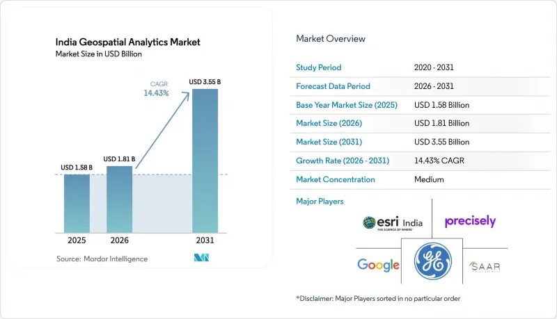
本報告按類型(表面分析、網路分析、地理視覺化等)、元件(軟體和服務)、部署模式(本地部署等)、應用程式(定位服務、災害管理和緊急應變等)以及最終用戶產業(農業、公共產業和電信等)進行細分。市場預測以美元計價。
印度地理空間分析市場趨勢與洞察
2022年國家地理空間政策自由化
2022年實施的政策消除了安全審查的障礙,並引入了自我認證體系,使印度公司能夠創建先前僅限於政府機構使用的高解析度地圖。目前,覆蓋全國的CORS網路為測量員提供了厘米級的精度,而SVAMITVA計畫已對超過28萬個村莊進行了數位化,產生了詳細的土地記錄數據,支持各種分析應用場景。強制性開放標準吸引了私人資本,預計到2025年,印度地理空間分析市場規模將達到5.2億印度盧比。由於外國公司必須與印度合作夥伴合作才能進行實地調查,因此印度本土供應商擁有監管優勢,這不僅保護了資料主權,也促進了當地就業。
5G 和 FTTH 的快速部署需要利用 GIS 進行網路設計。
通訊業者は、46万9,000基の5G基地局を設置し、全地区の99.6%をカバーしており、カバレッジを最大化し、設備投資を最小限に抑える空間計画ツールの緊急な必要性を高めています。「GatiShakti Sanchar」ポータルは、用地使用権の承認を一元化し、光ファイバー敷設の期間を短縮するとともに、土木工事の重複を削減しています。リライアンス,ジオによる17都市にわたる7,544万米ドルの拡張計画は、地理空間需要の財政的規模を浮き彫りにしています(INVESTINDIAGRID)。将来の6G調査、すなわち「バーラト6Gビジョン」の下で資金提供を受ける111のプロジェクトでは、さらに高密度なセル配置が必要となり、リアルタイムの位置情報分析への需要がさらに高まるでしょう。
認證GIS專業人員長期短缺
到2027年,印度需要125萬名人工智慧專家,然而,地理空間模組在大多數工程課程中仍然處於邊緣地位。光是水資源機構就需要3.5萬名訓練有素的員工來操作地理資訊系統(GIS)應用。主要大都會圈以外的人才短缺問題尤其嚴重,阻礙了印度地理空間分析市場滲透到農村發展計畫。
細分市場分析
至2025年,網路分析將佔印度地理空間分析市場35.10%的佔有率。通訊業者依靠射頻傳播模型和地形分析來設計大型基地台和小型基地台的部署位置,以實現全國範圍的5G網路部署。公共產業正在部署類似的工具集來最佳化光纖和電網線路,而交通負責人則利用連接分析來緩解交通走廊的擁塞。印度地理空間分析市場中的地理空間視覺化市場預計將以15.02%的複合年成長率成長,這表明市場正朝著基於儀錶板的決策工具方向發展,這些工具能夠簡化複雜的空間資料集。在以公民為中心的管治的推動下,政府機構需要互動式3D城市模型和即時移動孿生模型來進行場景測試。零售商和物流公司正在將以地圖為中心的商業智慧層整合到車輛路徑規劃和暗店部署中,這表明該技術在私營部門中得到了廣泛應用。
隨著資料日益複雜,「資料整合與轉換」(即將衛星影像、地籍圖和物聯網資料整合到統一的模式中)的重要性也日益凸顯。 「PM Gati Shakti」平台就是一個多層融合的典型案例,它整合了1600個資料集,用於協調基礎設施建設。印度太空研究組織(ISRO)藍圖發射50顆人工智慧衛星,預計資料量將大幅成長,這將進一步推動對自動化資料管道的需求,以清洗、標註影像資料並將其傳輸到分析引擎。
到2025年,軟體將佔據印度地理空間分析市場60.78%的佔有率。這主要歸功於公共和私營機構對GIS套件、圖像伺服器和空間SQL資料庫的授權使用。然而,服務收入規模正以15.55%的複合年成長率成長,因為成功實施需要資料遷移、模型客製化和雲端協作。 Esri印度在政府市場上提供的託管服務清晰地展現了向基於結果的合約模式的轉變,這種模式將軟體、託管和SLA打包在一起。保險公司正在外包作物產量檢驗演算法,這些演算法整合了Sentinel的圖像資料和精算表,需要其內部團隊通常不具備的跨學科專業知識。對於小規模的市政機構而言,託管服務使它們能夠避免購買硬體,並且每個機構都可以在國家主權雲上使用付費使用制的分析服務。
其他好處:
- Excel格式的市場預測(ME)表
- 3個月的分析師支持
目錄
第1章:引言
- 研究假設和市場定義
- 調查範圍
第2章:調查方法
第3章執行摘要
第4章 市場狀況
- 市場概覽
- 市場促進因素
- 2022年國家地理空間政策自由化
- 利用地理資訊系統 (GIS) 進行網路設計是快速部署 5G 和 FTTH 的必要條件。
- 衛星和無人機影像正在推動精密農業的普及。
- 智慧城市資本投資“Gati Shakti”和“AMRUT 2.0”
- 快速商務領域對超本地化位置智慧的需求日益成長。
- 人工智慧驅動的氣候變遷保險風險評分
- 市場限制因素
- 認證GIS專業人員長期短缺
- 各州採購流程分散
- 傳統地籍資料準確性有問題
- 中小企業取得地球觀測衛星資料的成本過高。
- 監理情勢
- 技術展望
- 投資分析
- 波特五力分析
- 宏觀經濟因素對市場的影響
第5章 市場規模與成長預測
- 按類型
- 表面分析
- 網路分析
- 地理資訊視覺化
- 地理編碼和反向地理編碼
- 資料整合與轉換
- 其他類型
- 按組件
- 軟體
- 服務
- 部署模式
- 現場
- 基於雲端的
- 混合
- 透過使用
- 定位服務
- 災害管理和緊急應變
- 氣候與環境監測
- 都市計畫與智慧城市
- 供應鍊和物流最佳化
- 資產追蹤與管理
- 保險和風險管理
- 其他用途
- 按最終用戶行業分類
- 農業
- 公共產業及通訊
- 國防與資訊
- 政府/公共安全
- 採礦和自然資源
- 汽車和運輸業
- 醫療保健和生命科學
- 房地產和建築
- 零售與電子商務
- 銀行業、金融服務業及保險業
- 其他行業
第6章 競爭情勢
- 市場集中度
- 策略趨勢
- 市佔率分析
- 公司簡介
- Esri India Technologies Private Limited
- Precisely Holdings LLC
- Google LLC
- CyberTech Systems and Software Limited
- SAAR IT Resources Private Limited
- General Electric Company
- Maxar Technologies Inc.
- EdgeMap Softwares Private Limited
- CSS Corp Private Limited
- Matrix Geo Solutions Private Limited
- RMSI Private Limited
- CE Info Systems Limited(MapmyIndia)
- Trimble Inc.
- Hexagon AB
- Planet Labs PBC
- GeoIQ Analytics Private Limited
- Cropway Agrotech Private Limited
- Magnasoft GeoSolutions Private Limited
- Heliware Technologies Private Limited
- Bhugol GIS Private Limited
- Tata Consultancy Services Limited
- Infosys Limited
- Oracle Corporation
- Bentley Systems Incorporated
第7章 市場機會與未來展望
According to Mordor Intelligence, the India geospatial analytics market size was valued at USD 1.58 billion in 2025 and estimated to grow from USD 1.81 billion in 2026 to reach USD 3.55 billion by 2031, at a CAGR of 14.43% during the forecast period (2026-2031).
This report is Segmented by Type (Surface Analysis, Network Analysis, Geovisualization, and More), Component (Software and Services), Deployment Mode (On-Premises, and More), Application (Location-Based Services, Disaster Management and Emergency Response, and More), End-User Vertical (Agriculture, Utilities and Communication, and More). The Market Forecasts are Provided in Terms of Value (USD).
India Geospatial Analytics Market Trends and Insights
Liberalized National Geospatial Policy 2022
The 2022 policy dismantled security-clearance bottlenecks and introduced self-certification, allowing Indian firms to create high-resolution maps once confined to government agencies. A nationwide CORS network now delivers centimeter-level accuracy to surveyors and the SVAMITVA program has digitized more than 2.8 lakh villages, producing granular land-records data that fuels diverse analytics use cases. Open-standards mandates invite private capital, pushing the India Geospatial Analytics market toward INR 52,000 crore valuation by 2025. Domestic providers gain a regulatory moat because foreign entities cannot conduct ground surveys without Indian partners, ensuring data sovereignty and boosting local employment.
Rapid 5G and FTTH Roll-outs demanding GIS-based network design
Telecom operators have installed 4.69 lakh 5G base transceiver stations covering 99.6% of districts, driving an urgent need for spatial planning tools that maximize coverage and minimize capital outlay. The GatiShakti Sanchar portal centralizes Right-of-Way approvals, cutting fiber deployment timelines and reducing duplication of civil works. Reliance Jio's USD 75.44 million expansion across 17 cities underscores the financial scale of geospatial demand INVESTINDIAGRID. Future 6G research, 111 projects funded under Bharat 6G Vision, will require even denser cell geographies, amplifying demand for real-time location intelligence.
Persistent shortage of certified GIS talent
India needs 1.25 million AI professionals by 2027, yet geospatial modules remain peripheral in most engineering curricula. Water-resources agencies alone require 35,000 trained staff for GIS applications. Scarcity is acute outside major metros, limiting the diffusion of the India Geospatial Analytics market into rural development programs.
Other drivers and restraints analyzed in the detailed report include:
- Precision-agri adoption fuelled by satellite and drone imagery
- Smart-city CAPEX under Gati Shakti and AMRUT 2.0
- Fragmented state-level procurement processes
For complete list of drivers and restraints, kindly check the Table Of Contents.
Segment Analysis
Network Analysis contributed 35.10% to the India Geospatial Analytics market in 2025. Telecom providers depend on RF propagation models and terrain analytics to design macro-cell and small-cell layers required for nationwide 5G. Utilities deploy similar toolsets to optimize fiber and power-grid routes, and transport planners rely on connectivity analytics to decongest corridors. The India Geospatial Analytics market size for Geovisualization is projected to expand at 15.02% CAGR, signaling a shift toward dashboard-based decision tools that simplify complex spatial datasets. Driven by citizen-centric governance, agencies demand interactive 3D city models and real-time mobility twins for scenario testing. Retailers and logistics firms embed map-centric BI layers to route fleets and place dark stores, indicating broad private-sector uptake.
Growing data complexity elevates Data Integration and Transformation, which fuses satellite imagery, cadastral maps and IoT feeds into unified schemas. The PM Gati Shakti platform exemplifies multi-layer fusion, integrating 1,600 datasets for infrastructure alignment. ISRO's roadmap of 50 AI-enabled satellites will multiply data volumes, reinforcing demand for automated pipelines that clean, label and stream imagery to analytics engines.
Software held 60.78% India Geospatial Analytics market share in 2025 as public and private bodies licensed GIS suites, imagery servers and spatial SQL databases. Yet the services revenue pool grows at 15.55% CAGR because successful roll-outs require data migration, model customization and cloud orchestration. Esri India's managed services on the Government e-Marketplace illustrate the shift toward outcome-based engagements that bundle software, hosting and SLAs. Insurance carriers outsource crop-yield validation algorithms that merge Sentinel imagery with actuarial tables, demanding cross-domain expertise that few in-house teams possess. For smaller municipalities, managed services circumvent hardware purchases, letting agencies access pay-per-use analytics on national sovereign clouds.
Complete Report Scope:
- By Type
- Surface Analysis
- Network Analysis
- Geovisualization
- Geocoding and Reverse Geocoding
- Data Integration and Transformation
- Other Types
- By Component
- Software
- Services
- By Deployment Mode
- On-premises
- Cloud-based
- Hybrid
- By Application
- Location-based Services
- Disaster Management and Emergency Response
- Climate and Environmental Monitoring
- Urban Planning and Smart Cities
- Supply-Chain and Logistics Optimisation
- Asset Tracking and Management
- Insurance and Risk Management
- Other Applications
- By End-user Vertical
- Agriculture
- Utilities and Communication
- Defense and Intelligence
- Government and Public Safety
- Mining and Natural Resources
- Automotive and Transportation
- Healthcare and Life Sciences
- Real Estate and Construction
- Retail and E-commerce
- Banking, Financial Services and Insurance
- Other Verticals
List of Companies Covered in this Report:
- Esri India Technologies Private Limited
- Precisely Holdings LLC
- Google LLC
- CyberTech Systems and Software Limited
- SAAR IT Resources Private Limited
- General Electric Company
- Maxar Technologies Inc.
- EdgeMap Softwares Private Limited
- CSS Corp Private Limited
- Matrix Geo Solutions Private Limited
- RMSI Private Limited
- CE Info Systems Limited (MapmyIndia)
- Trimble Inc.
- Hexagon AB
- Planet Labs PBC
- GeoIQ Analytics Private Limited
- Cropway Agrotech Private Limited
- Magnasoft GeoSolutions Private Limited
- Heliware Technologies Private Limited
- Bhugol GIS Private Limited
- Tata Consultancy Services Limited
- Infosys Limited
- Oracle Corporation
- Bentley Systems Incorporated
Additional Benefits:
- The market estimate (ME) sheet in Excel format
- 3 months of analyst support
TABLE OF CONTENTS
1 INTRODUCTION
- 1.1 Study Assumptions and Market Definition
- 1.2 Scope of the Study
2 RESEARCH METHODOLOGY
3 EXECUTIVE SUMMARY
4 MARKET LANDSCAPE
- 4.1 Market Overview
- 4.2 Market Drivers
- 4.2.1 Liberalized National Geospatial Policy 2022
- 4.2.2 Rapid 5G and FTTH Roll-outs demanding GIS-based network design
- 4.2.3 Precision-agri adoption fuelled by satellite and drone imagery
- 4.2.4 Smart-city CAPEX under Gati Shakti and AMRUT 2.0
- 4.2.5 Demand for hyper-local location-intelligence in quick-commerce
- 4.2.6 AI-driven risk-scoring for climate-linked insurance
- 4.3 Market Restraints
- 4.3.1 Persistent shortage of certified GIS talent
- 4.3.2 Fragmented state-level procurement processes
- 4.3.3 Legacy cadastral data accuracy issues
- 4.3.4 High EO-satellite data costs for SMEs
- 4.4 Regulatory Landscape
- 4.5 Technological Outlook
- 4.6 Investment Analysis
- 4.7 Porter's Five Forces Analysis
- 4.7.1 Bargaining Power of Buyers
- 4.7.2 Bargaining Power of Suppliers
- 4.7.3 Threat of New Entrants
- 4.7.4 Threat of Substitutes
- 4.7.5 Intensity of Competitive Rivalry
- 4.8 Impact of Macroeconomic Factors on the Market
5 MARKET SIZE AND GROWTH FORECASTS (VALUE)
- 5.1 By Type
- 5.1.1 Surface Analysis
- 5.1.2 Network Analysis
- 5.1.3 Geovisualization
- 5.1.4 Geocoding and Reverse Geocoding
- 5.1.5 Data Integration and Transformation
- 5.1.6 Other Types
- 5.2 By Component
- 5.2.1 Software
- 5.2.2 Services
- 5.3 By Deployment Mode
- 5.3.1 On-premises
- 5.3.2 Cloud-based
- 5.3.3 Hybrid
- 5.4 By Application
- 5.4.1 Location-based Services
- 5.4.2 Disaster Management and Emergency Response
- 5.4.3 Climate and Environmental Monitoring
- 5.4.4 Urban Planning and Smart Cities
- 5.4.5 Supply-Chain and Logistics Optimisation
- 5.4.6 Asset Tracking and Management
- 5.4.7 Insurance and Risk Management
- 5.4.8 Other Applications
- 5.5 By End-user Vertical
- 5.5.1 Agriculture
- 5.5.2 Utilities and Communication
- 5.5.3 Defense and Intelligence
- 5.5.4 Government and Public Safety
- 5.5.5 Mining and Natural Resources
- 5.5.6 Automotive and Transportation
- 5.5.7 Healthcare and Life Sciences
- 5.5.8 Real Estate and Construction
- 5.5.9 Retail and E-commerce
- 5.5.10 Banking, Financial Services and Insurance
- 5.5.11 Other Verticals
6 COMPETITIVE LANDSCAPE
- 6.1 Market Concentration
- 6.2 Strategic Moves
- 6.3 Market Share Analysis
- 6.4 Company Profiles (includes Global level Overview, Market level overview, Core Segments, Financials as available, Strategic Information, Market Rank/Share for key companies, Products and Services, and Recent Developments)
- 6.4.1 Esri India Technologies Private Limited
- 6.4.2 Precisely Holdings LLC
- 6.4.3 Google LLC
- 6.4.4 CyberTech Systems and Software Limited
- 6.4.5 SAAR IT Resources Private Limited
- 6.4.6 General Electric Company
- 6.4.7 Maxar Technologies Inc.
- 6.4.8 EdgeMap Softwares Private Limited
- 6.4.9 CSS Corp Private Limited
- 6.4.10 Matrix Geo Solutions Private Limited
- 6.4.11 RMSI Private Limited
- 6.4.12 CE Info Systems Limited (MapmyIndia)
- 6.4.13 Trimble Inc.
- 6.4.14 Hexagon AB
- 6.4.15 Planet Labs PBC
- 6.4.16 GeoIQ Analytics Private Limited
- 6.4.17 Cropway Agrotech Private Limited
- 6.4.18 Magnasoft GeoSolutions Private Limited
- 6.4.19 Heliware Technologies Private Limited
- 6.4.20 Bhugol GIS Private Limited
- 6.4.21 Tata Consultancy Services Limited
- 6.4.22 Infosys Limited
- 6.4.23 Oracle Corporation
- 6.4.24 Bentley Systems Incorporated
7 MARKET OPPORTUNITIES AND FUTURE OUTLOOK
- 7.1 White-space and Unmet-need Assessment

 中東地理空間分析:市場佔有率分析、產業趨勢與統計、成長預測(2026-2031)法國地理分析:市場佔有率分析、產業趨勢與統計、成長預測(2026-2031)澳新銀行地理空間分析:市場佔有率分析、產業趨勢與統計、成長預測(2026-2031 年)東協地理空間分析:市場佔有率分析、產業趨勢與統計及成長預測(2026-2031)地理空間分析:市場佔有率分析、產業趨勢與統計、成長預測(2026-2031)
 地理空間分析市場:2026-2032年全球市場預測(依組件、技術、資料類型、部署模式、組織規模及應用分類)
 2026-2030年全球地理空間分析市場
 地理空間分析市場規模、佔有率和趨勢分析報告:按組件、類型、應用、地區和細分市場預測(2026-2033 年)
 地理空間分析市場規模、佔有率和成長分析:按組件、分析類型、部署模式、最終用戶產業和地區分類-2026-2033年產業預測
 地理空間分析市場報告:按組件、類型、技術、企業規模、部署模式、產業和地區分類(2026-2034 年)