


 |
市場調查報告書
商品編碼
2119641
中東地理空間分析:市場佔有率分析、產業趨勢與統計、成長預測(2026-2031)Middle East Geospatial Analytics - Market Share Analysis, Industry Trends & Statistics, Growth Forecasts (2026 - 2031) |
||||||

※ 本網頁內容可能與最新版本有所差異。詳細情況請與我們聯繫。
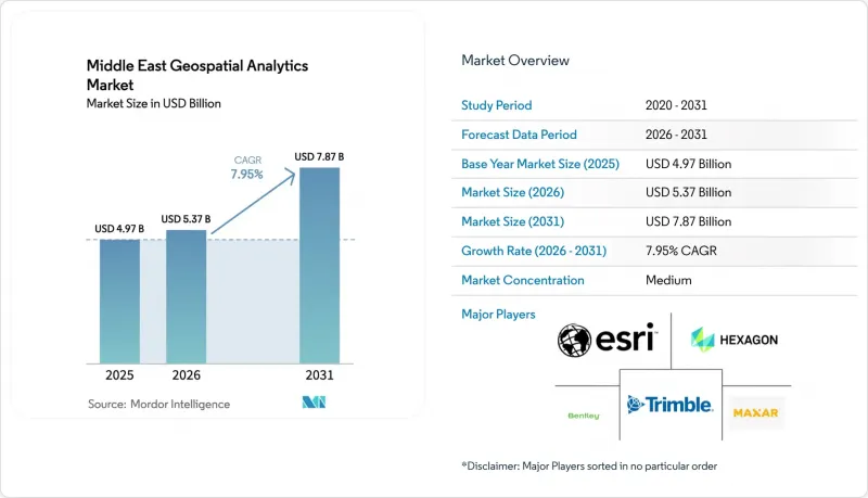
據 Mordor Intelligence 稱,2025 年中東地理空間分析市值為 49.7 億美元,預計到 2031 年將達到 78.7 億美元,而 2026 年為 53.7 億美元,預測期(2026-2031 年)的複合年成長率為 7.95%。
本報告按組件(解決方案和服務)、分析類型(說明分析、診斷性分析等)、部署模式(本地部署、雲端部署、邊緣/混合部署)、應用程式(表面和地形分析、網路和路徑分析等)、最終用戶產業(國防和情報機構、政府和地方當局等)以及國家/地區進行分類。
中東地理空間分析市場趨勢與洞察
智慧城市計畫正在海灣合作理事會地區迅速發展。
在海灣各國的大型企劃中,地理空間分析正被整合到城市管理架構中。杜拜的「2040年城市總體規劃」旨在將綠地面積擴大一倍,同時服務780萬人口,這需要即時空間建模來實現「20分鐘城市」的概念。沙烏地阿拉伯與Naver合作,為利雅德和其他四個城市提供了10公分解析度的3D孿生模型,因此能夠進行洪水模擬和基礎設施最佳化。阿拉伯聯合大公國耗資25億美元的「Aion Sentia」平台整合了人工智慧驅動的空間數據,以實現城市服務的端到端協調。這些項目正在為中東地理空間分析市場創造可預測的多年需求,包括大規模影像擷取、進階路徑分析和預測性保護模型。
利用衛星技術強制更新土地登記簿
新的土地登記法要求達到亞米級精度並建立審計追蹤,迫使各機構遷移到基於雲端的空間資料基礎設施。沙烏地阿拉伯的「全球人工智慧中心法」草案定義了「私有」、「增強型」和「虛擬」中心,在規範主權託管的同時,也促進了跨國地籍資訊的整合。阿拉伯聯合大公國的穆罕默德·本·扎耶德衛星(MBZ-SAT)將提升該國的地球觀測能力,並加速地塊資料庫的更新週期。科威特正在下游流程中展現其價值。該國公共產業部透過將地籍圖層整合到其地理資訊系統(GIS)工作流程中,縮短了服務連接時間。標準化的地籍底圖能夠對課稅、基礎設施規劃和環境監測進行更全面的分析。
關於地理空間資料主權的法規
分散的在地化要求加重了跨國公司在部署過程中的合規負擔。沙烏地阿拉伯的「全球人工智慧中心法」草案規定了三種不同的託管模式,審計義務各不相同,這使得區域資料湖架構更加複雜。阿拉伯聯合大公國的本地化法規迫使外國供應商設立本地基地或成立合資企業,導致部署週期延長。中國超大規模資料中心業者在沿岸地區的快速擴張,加劇了地緣政治因素對平台選擇和加密標準的審查。這些因素給中東地理空間分析市場的中小型供應商帶來了壓力,並延長了採購週期。
細分市場分析
預計到2025年,解決方案將繼續主導中東地理空間分析市場,佔據68.60%的市場。這反映了對軟體套件和感測器硬體的既有投資。然而,隨著各國政府和企業擴大將整合、模型訓練和全天候管理的分析服務外包,服務領域正以11.05%的複合年成長率快速成長。該地區深度學習GIS專家的短缺使得供應商提供的專業服務成為快速部署的可行途徑。各國政府更傾向於整合資料擷取管道、自主雲端託管和阿拉伯語介面的承包框架。
服務供應商正利用策略合作夥伴關係來加強與各行業的聯繫。 Bentley Systems 透過整合 Google 的地理空間內容,並在數位孿生工作流程中提供更豐富的上下文信息,從而支援基礎設施即服務 (IaaS) 的交付。其託管服務組合現已涵蓋衛星圖像的持續更新、AI 模型重新訓練和網路彈性審計。由於中東地理空間分析市場優先考慮速度而非建立內部能力,這些技術進步有望佔據不斷成長的營運支出 (OPEX) 預算。
說明分析透過提供儀錶板和跨土地、資產和人口資料集的歷史模式識別,在2025年保持了43.25%的收入佔有率。同時,受交通協調、能源負荷平衡和緊急應變路線規劃等領域自動化最佳化需求的推動,指示性分析以10.28%的年成長率成長。國防集團EDGE宣布推出一款由人工智慧驅動的地理空間平台,該平台能夠推薦並自動執行關鍵任務操作,凸顯了向行動導向引擎加速轉型的趨勢。
各組織正遵循一條成熟度曲線,從說明分析發展到預測性分析、診斷性指示性分析,其中後幾個階段在預算分配中越來越受到重視。對人工智慧可解釋性的信心以及5G邊緣連接的結合,正在將決策週期從幾分鐘縮短到幾秒鐘,加速高附加價值分析層在中東地理空間分析市場的滲透。
其他好處:
- Excel格式的市場預測(ME)表
- 3個月的分析師支持
目錄
第1章:引言
- 研究假設和市場定義
- 調查範圍
第2章:調查方法
第3章執行摘要
第4章 市場狀況
- 市場概覽
- 市場促進因素
- 智慧城市計畫正在海灣合作理事會地區迅速發展。
- 利用衛星進行地籍資訊強制性現代化
- 公共產業公司快速遷移到基於雲端的地理資訊系統
- 引入利用5G技術的邊緣分析
- 阿拉伯聯合大公國自由區地理人工智慧新創企業的崛起
- 從石油業向非石油業實現經濟多元化項目
- 市場限制因素
- 關於地理空間資料主權的法規
- 深度學習地理資訊系統領域熟練人才短缺
- 零散的傳統地籍資料集
- LiDAR和合成孔徑雷達的購置成本很高。
- 產業價值鏈分析
- 監理情勢
- 技術展望
- 產業吸引力—五力分析
- 買方的議價能力
- 供應商的議價能力
- 新進入者的威脅
- 替代品的威脅
- 競爭公司之間的競爭
- 宏觀經濟因素對市場的影響
第5章 市場規模與成長預測
- 按組件
- 解決方案
- 服務
- 按分析類型
- 說明分析
- 診斷分析
- 預測分析
- 指示性分析
- 部署模式
- 現場
- 雲
- 邊緣/混合
- 透過使用
- 表面和地形分析
- 網路和路由分析
- 地理資訊視覺化和3D建模
- 影像和遙感探測分析
- 按最終用戶行業分類
- 國防與資訊
- 政府和地方當局
- 公共產業和能源
- 農業/環境
- 運輸/物流
- 房地產和建築
- 採礦和自然資源
- 醫療和公共衛生
- 其他終端用戶產業
- 國家
- 阿拉伯聯合大公國
- 沙烏地阿拉伯
- 土耳其
- 卡達
- 阿曼
- 其他中東國家
第6章 競爭情勢
- 市場集中度
- 策略趨勢
- 市佔率分析
- 公司簡介
- Esri Inc.
- Hexagon AB
- Trimble Inc.
- Bentley Systems Inc.
- Maxar Technologies
- HERE Technologies
- CARTO
- Planet Labs PBC
- Space Imaging Middle East
- Openware
- MindEarth AI
- Alteryx Inc.
- Oracle Corporation
- Google LLC(Alphabet)
- Microsoft Corp.
- AWS(Amazon Web Services)
- IBM Corporation
- SAP SE
- TomTom NV
- Fugro NV
- BlackSky Technology Inc.
- Airbus Defence & Space
- Harris Geospatial Solutions
- Eos Data Analytics
- AtkinsRealis
第7章 市場機會與未來趨勢
- 評估閒置頻段和未滿足的需求
According to Mordor Intelligence, the Middle East geospatial analytics market size was valued at USD 4.97 billion in 2025 and estimated to grow from USD 5.37 billion in 2026 to reach USD 7.87 billion by 2031, at a CAGR of 7.95% during the forecast period (2026-2031).
This report is Segmented by Component (Solutions and Services), Analytics Type (Descriptive Analytics, Diagnostic Analytics, and More), Deployment Mode (On-Premise, Cloud, and Edge/Hybrid), Application (Surface and Terrain Analysis, Network and Route Analysis, and More), End-User Industry (Defense and Intelligence, Government and Municipalities, and More), and Country.
Middle East Geospatial Analytics Market Trends and Insights
Surging Smart-City Programs Across GCC
Gulf megaprojects are hard-wiring geospatial analytics into urban-management architectures. Dubai's 2040 Urban Master Plan doubles green areas while targeting a population of 7.8 million, demanding real-time spatial modelling for the "20-minute city" concept. Saudi Arabia's partnership with Naver is delivering 10-cm resolution 3-D twins for Riyadh and four additional cities, enabling flood simulation and infrastructure optimisation. The USD 2.5 billion Aion Sentia platform in the UAE integrates AI-driven spatial data to orchestrate city services end-to-end. These projects create predictable, multi-year demand for high-volume imagery ingestion, advanced routing analytics, and predictive maintenance models inside the Middle East geospatial analytics market.
Mandated Satellite-Based Cadastral Modernization
New land-registration statutes require sub-meter accuracy and audit trails, pushing agencies toward cloud-enabled spatial data infrastructures. Saudi Arabia's draft Global AI Hub Law outlines "Private," "Extended," and "Virtual" hubs, formalising sovereign hosting while enabling cross-border cadastral integration. The UAE's MBZ-SAT will lift domestic earth-observation capacity, accelerating update cycles for parcel databases. Kuwait demonstrates downstream value: its utilities ministry cut service-connection times after embedding cadastral layers into a GIS workflow. Standardised cadastral basemaps unlock richer analytics in taxation, infrastructure planning, and environmental monitoring.
Geospatial-Data Sovereignty Regulations
Fragmented localisation mandates elevate compliance overheads for multinational deployments. Saudi Arabia's draft Global AI Hub Law prescribes three distinct hosting archetypes with divergent audit obligations, complicating regional data-lake architectures. The UAE's localisation rules force foreign providers to build local points of presence or enter joint ventures, lengthening deployment timelines. Intensifying Chinese hyperscaler expansion in the Gulf introduces geopolitical scrutiny over platform selection and encryption standards. These dynamics squeeze smaller vendors and prolong procurement cycles within the Middle East geospatial analytics market.
Other drivers and restraints analyzed in the detailed report include:
- Rapid Cloud-GIS Migration by Utilities
- 5G-Enabled Edge Analytics Roll-Outs
- Skilled-Talent Shortage for Deep-Learning GIS
For complete list of drivers and restraints, kindly check the Table Of Contents.
Segment Analysis
Solutions continued to dominate the Middle East geospatial analytics market with a 68.60% share in 2025, reflecting entrenched investments in software suites and sensor hardware. However, the services segment is expanding at an 11.05% CAGR as ministries and enterprises outsource integration, model training, and 24/7 managed analytics. Regional shortages in deep-learning GIS specialists make vendor-delivered professional services the pragmatic route for rapid roll-out. Governments favour turnkey frameworks that bundle data-ingestion pipelines, sovereign cloud hosting, and Arabic language interfaces.
Service providers leverage strategic alliances to deepen vertical intimacy. Bentley Systems integrated Google geospatial content to deliver richer context within digital-twin workflows, underpinning infrastructure-as-a-service offerings. Managed-service portfolios now include continuous satellite imagery updates, AI model retraining, and cyber-resilience audits. This evolution positions the services cohort to capture rising OPEX budgets as the Middle East geospatial analytics market prioritises speed over in-house capability building.
Descriptive analytics retained 43.25% revenue share in 2025 by providing dashboards and historical pattern recognition across land, asset, and population datasets. Yet prescriptive analytics is growing 10.28% annually, propelled by demand for automated optimisation in traffic orchestration, energy load balancing, and emergency-response routing. Defence conglomerate EDGE unveiled an AI-enabled geospatial platform able to recommend and auto-execute mission-critical manoeuvres, underscoring momentum toward action-oriented engines.
Organisations move through a maturity curve starting with descriptive and evolving to predictive, diagnostic, and finally prescriptive; budget allocations increasingly prioritise the latter stages. Confidence in AI explainability, combined with 5G edge connectivity, allows decision loops to compress from minutes to seconds, boosting market penetration for higher-value analytics tiers within the Middle East geospatial analytics market.
Complete Report Scope:
- By Component
- Solutions
- Services
- By Analytics Type
- Descriptive Analytics
- Diagnostic Analytics
- Predictive Analytics
- Prescriptive Analytics
- By Deployment Mode
- On-premise
- Cloud
- Edge/Hybrid
- By Application
- Surface and Terrain Analysis
- Network and Route Analysis
- Geovisualization and 3-D Modelling
- Imagery and Remote-Sensing Analytics
- By End-user Industry
- Defense and Intelligence
- Government and Municipalities
- Utilities and Energy
- Agriculture and Environment
- Transportation and Logistics
- Real Estate and Construction
- Mining and Natural Resources
- Healthcare and Public Health
- Other End-user Industries
- By Country
- United Arab Emirates
- Saudi Arabia
- Turkey
- Qatar
- Oman
- Rest of Middle East
List of Companies Covered in this Report:
- Esri Inc.
- Hexagon AB
- Trimble Inc.
- Bentley Systems Inc.
- Maxar Technologies
- HERE Technologies
- CARTO
- Planet Labs PBC
- Space Imaging Middle East
- Openware
- MindEarth AI
- Alteryx Inc.
- Oracle Corporation
- Google LLC (Alphabet)
- Microsoft Corp.
- AWS (Amazon Web Services)
- IBM Corporation
- SAP SE
- TomTom N.V.
- Fugro N.V.
- BlackSky Technology Inc.
- Airbus Defence & Space
- Harris Geospatial Solutions
- Eos Data Analytics
- AtkinsRealis
Additional Benefits:
- The market estimate (ME) sheet in Excel format
- 3 months of analyst support
TABLE OF CONTENTS
1 INTRODUCTION
- 1.1 Study Assumptions and Market Definition
- 1.2 Scope of the Study
2 RESEARCH METHODOLOGY
3 EXECUTIVE SUMMARY
4 MARKET LANDSCAPE
- 4.1 Market Overview
- 4.2 Market Drivers
- 4.2.1 Surging smart-city programs across GCC
- 4.2.2 Mandated satellite-based cadastral modernization
- 4.2.3 Rapid cloud-GIS migration by utilities
- 4.2.4 5G-enabled edge analytics roll-outs
- 4.2.5 Rise of geo-AI startups in UAE free zones
- 4.2.6 Oil-to-non-oil economic diversification projects
- 4.3 Market Restraints
- 4.3.1 Geospatial-data sovereignty regulations
- 4.3.2 Skilled-talent shortage for deep-learning GIS
- 4.3.3 Fragmented legacy cadastral datasets
- 4.3.4 High LiDAR and SAR acquisition costs
- 4.4 Industry Value Chain Analysis
- 4.5 Regulatory Landscape
- 4.6 Technological Outlook
- 4.7 Industry Attractiveness - Porter's Five Forces Analysis
- 4.7.1 Bargaining Power of Buyers
- 4.7.2 Bargaining Power of Suppliers
- 4.7.3 Threat of New Entrants
- 4.7.4 Threat of Substitutes
- 4.7.5 Intensity of Competitive Rivalry
- 4.8 Impact of Macroeconomic Factors on the Market
5 MARKET SIZE AND GROWTH FORECASTS (VALUES)
- 5.1 By Component
- 5.1.1 Solutions
- 5.1.2 Services
- 5.2 By Analytics Type
- 5.2.1 Descriptive Analytics
- 5.2.2 Diagnostic Analytics
- 5.2.3 Predictive Analytics
- 5.2.4 Prescriptive Analytics
- 5.3 By Deployment Mode
- 5.3.1 On-premise
- 5.3.2 Cloud
- 5.3.3 Edge/Hybrid
- 5.4 By Application
- 5.4.1 Surface and Terrain Analysis
- 5.4.2 Network and Route Analysis
- 5.4.3 Geovisualization and 3-D Modelling
- 5.4.4 Imagery and Remote-Sensing Analytics
- 5.5 By End-user Industry
- 5.5.1 Defense and Intelligence
- 5.5.2 Government and Municipalities
- 5.5.3 Utilities and Energy
- 5.5.4 Agriculture and Environment
- 5.5.5 Transportation and Logistics
- 5.5.6 Real Estate and Construction
- 5.5.7 Mining and Natural Resources
- 5.5.8 Healthcare and Public Health
- 5.5.9 Other End-user Industries
- 5.6 By Country
- 5.6.1 United Arab Emirates
- 5.6.2 Saudi Arabia
- 5.6.3 Turkey
- 5.6.4 Qatar
- 5.6.5 Oman
- 5.6.6 Rest of Middle East
6 COMPETITIVE LANDSCAPE
- 6.1 Market Concentration
- 6.2 Strategic Moves
- 6.3 Market Share Analysis
- 6.4 Company Profiles (includes Global level Overview, Market level overview, Core Segments, Financials as available, Strategic Information, Market Rank/Share for key companies, Products and Services, and Recent Developments)
- 6.4.1 Esri Inc.
- 6.4.2 Hexagon AB
- 6.4.3 Trimble Inc.
- 6.4.4 Bentley Systems Inc.
- 6.4.5 Maxar Technologies
- 6.4.6 HERE Technologies
- 6.4.7 CARTO
- 6.4.8 Planet Labs PBC
- 6.4.9 Space Imaging Middle East
- 6.4.10 Openware
- 6.4.11 MindEarth AI
- 6.4.12 Alteryx Inc.
- 6.4.13 Oracle Corporation
- 6.4.14 Google LLC (Alphabet)
- 6.4.15 Microsoft Corp.
- 6.4.16 AWS (Amazon Web Services)
- 6.4.17 IBM Corporation
- 6.4.18 SAP SE
- 6.4.19 TomTom N.V.
- 6.4.20 Fugro N.V.
- 6.4.21 BlackSky Technology Inc.
- 6.4.22 Airbus Defence & Space
- 6.4.23 Harris Geospatial Solutions
- 6.4.24 Eos Data Analytics
- 6.4.25 AtkinsRealis
7 MARKET OPPORTUNITIES AND FUTURE TRENDS
- 7.1 White-Space and Unmet-Need Assessment

 法國地理分析:市場佔有率分析、產業趨勢與統計、成長預測(2026-2031)澳新銀行地理空間分析:市場佔有率分析、產業趨勢與統計、成長預測(2026-2031 年)東協地理空間分析:市場佔有率分析、產業趨勢與統計及成長預測(2026-2031)地理空間分析:市場佔有率分析、產業趨勢與統計、成長預測(2026-2031)
 地理空間分析市場:2026-2032年全球市場預測(依組件、技術、資料類型、部署模式、組織規模及應用分類)印度地理空間分析:市場佔有率分析、產業趨勢與統計、成長預測(2026-2031)
 2026-2030年全球地理空間分析市場
 地理空間分析市場規模、佔有率和趨勢分析報告:按組件、類型、應用、地區和細分市場預測(2026-2033 年)
 地理空間分析市場規模、佔有率和成長分析:按組件、分析類型、部署模式、最終用戶產業和地區分類-2026-2033年產業預測
 地理空間分析市場報告:按組件、類型、技術、企業規模、部署模式、產業和地區分類(2026-2034 年)