


 |
市場調查報告書
商品編碼
2119640
法國地理分析:市場佔有率分析、產業趨勢與統計、成長預測(2026-2031)France Geospatial Analytics - Market Share Analysis, Industry Trends & Statistics, Growth Forecasts (2026 - 2031) |
||||||

※ 本網頁內容可能與最新版本有所差異。詳細情況請與我們聯繫。
根據 Mordor Intelligence 預測,法國地理空間分析市場規模預計將從 2025 年的 16.5 億美元成長到 2026 年的 17.9 億美元,然後從 2026 年到 2031 年以 8.24% 的複合年成長率成長,到 2031 年達到 26.5 億美元。
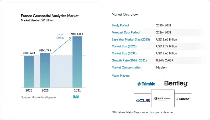
本報告按類型(表面分析、網路分析、地理視覺化)、最終用戶產業(農業、公共產業和通訊、國防和資訊、政府機構、採礦和自然資源、汽車和運輸、醫療保健、房地產和建築等)以及地區進行分類。
法國地理空間分析市場的趨勢與洞察
對智慧城市和交通出行領域的投資正在激增。
法國計劃在2025年投資4.75億歐元用於道路建設,並額外投資2.94億歐元用於道路維護。由於市政當局只有在能夠證明其效率提升的情況下才能獲得這些資金,因此對能夠近乎即時地追蹤道路狀況、交通流量和碳足跡的地理空間儀錶板的需求日益成長。伊斯特爾的私人5G網路已證明,地理空間分析可以在緊急應變下提高路線確定的準確性,同時將市政營運成本降低40%。由法國國家地理研究所(IGN)、法國國家道路與交通工程研究中心(Cerema)和法國國家資訊與自動化研究所(Inria)主導的國家數位孿生平台將使城市能夠模擬洪水、城市熱島效應和交通狀況等場景,並將空間資料轉化為預測性資產管理工具。法國對互通性標準的承諾確保了在35,000個市鎮實現可複製的部署,從而為提供與新標準相容軟體的供應商創造了永續的收入來源。隨著LiDAR、CCTV和感測器資料量的增加,法國地理空間分析市場將從單純的說明地圖繪製轉向主動決策支援。
對國防衛星星系(CSO-3)的需求
耗資7.95億歐元的CSO計畫在法國的指揮下提供35公分解析度的衛星影像,並符合北約戰略情報標準。數據商業化條款確保數據能夠安全地分發給值得信賴的歐洲合作夥伴,開闢了先前不存在的出口管道。烏克蘭與賽峰集團旗下子公司簽署的一份2025年合約規定,將CSO資料整合到該國的國防規劃平台中,凸顯了該衛星衛星星系在法國以外市場的潛力。下游企業,如保險公司、公共產業和林業相關人員,也將獲得先前僅限於國防部門的空間精度數據。此衛星星座與C40S空間態勢感知系統整合,使人工智慧演算法能夠檢測異常情況,並向民用和軍用用戶發送即時警報。隨著新應用案例的不斷湧現,交易量持續成長,進一步鞏固了衛星資料作為法國地理空間分析市場基石的地位。
高昂的整合和遷移成本
包括資料擷取管道、感測器閘道器和培訓項目在內的成本,一套完整的地理空間系統的實施成本可能超過50萬歐元。 2024年第三季建設業產出下降8.4%後,許多中小企業推遲了項目,顯示空間IT預算對宏觀經濟狀況非常敏感。傳統的資源規劃軟體通常缺乏空間領域功能,迫使企業購買中間件或聘請專業整合商。這增加了整體擁有成本,使得其投資回報期不如投資基於雲端的CRM或ERP系統那樣具有吸引力。在「即插即用」連接器成熟之前,高昂的進入門檻可能會阻礙法國地理空間分析市場的成長。
細分市場分析
預計到2025年,地理空間視覺化將在法國地理空間分析市場佔據37.35%的佔有率。這反映了公共部門對以地圖為中心的儀錶板的需求,即使沒有技術專長的員工也能快速理解這些儀錶板。預算負責人正在使用顏色編碼圖層來評估基礎設施風險,而葡萄園管理人員則使用移動熱圖來監測植物的壓力程度。隨著3D引擎和基於瀏覽器的點雲渲染器打破了工作站的限制,預計法國地理空間分析市場中的地理空間視覺化市場將以7.12%的複合年成長率成長。供應商正在整合語音導航和對比度切換等輔助功能,這得益於里昂第一大學克勞德·貝爾納分校的研究,該研究表明行動地理空間視覺化對視障用戶具有許多益處。
網路分析是成長最快的細分市場,預計到2031年將以13.15%的複合年成長率成長。這一快速成長與電動車充電樁的廣泛部署密切相關,負責人需要評估充電站之間的最佳間距及其對電網的影響。對於地表分析,精密農業和採礦客戶的需求預計將保持穩定,他們需要等高線圖來制定地形施肥計劃和爆破風險評估。各細分市場成長勢頭的協同效應表明,法國地理空間分析市場將從靜態地圖繪製擴展到在單一介面中整合路徑、接近性和高程參數的分析工作流程。
其他好處:
- Excel格式的市場預測(ME)表
- 3個月的分析師支持
目錄
第1章:引言
- 研究假設和市場定義
- 調查範圍
第2章:調查方法
第3章執行摘要
第4章 市場狀況
- 市場概覽
- 市場促進因素
- 對智慧城市和交通出行的資金投入正在激增。
- 對國防衛星星系(CSO-3)的需求
- ESG和綠色預算合規義務
- 利用5G物聯網實現即時數據流
- 關於對生物多樣性影響的報告義務(2026 年)
- 精準葡萄栽培平台的引進
- 市場限制因素
- 高昂的整合和遷移成本
- 地理資料科學領域人才短缺
- 地方政府資料標準碎片化
- 雲端主權託管限制
- 價值鏈分析
- 監理情勢
- 技術展望
- 波特五力分析
- 產業價值鏈分析
- 新冠疫情影響評估
第5章 市場規模與成長預測
- 按類型
- 表面分析
- 網路分析
- 地理視覺化
- 按最終用戶行業分類
- 農業
- 公共產業及通訊
- 國防與資訊
- 政府
- 採礦和自然資源
- 汽車和運輸業
- 衛生保健
- 房地產和建築
- 其他終端用戶產業
第6章 競爭情勢
- 市場集中度
- 策略趨勢
- 市佔率分析
- 公司簡介
- Esri France
- Airbus Defence and Space Intelligence
- Thales Alenia Space
- Hexagon AB(Leica Geosystems)
- Bentley Systems France
- Safran(AI and geospatial)
- IGN(Geoservices)
- CLS Groupe
- Intermap Technologies
- Trimble Geospatial
- ACWA Robotics
- Preligens
- Nestwave SAS
- Preligens
- AlphaGeoMega SAS
- Geomatys
- CartONG
- Galigeo
- JLL France(Geo-BI)
- Gismed
第7章 市場機會與未來展望
According to Mordor Intelligence, the France geospatial analytics market size is expected to grow from USD 1.65 billion in 2025 to USD 1.79 billion in 2026 and is forecast to reach USD 2.65 billion by 2031 at 8.24% CAGR over 2026-2031.
This report is Segmented by Type (Surface Analysis, Network Analysis, and Geovisualization) by End User Vertical (Agriculture, Utility and Communication, Defense and Intelligence, Government, Mining and Natural Resources, Automotive and Transportation, Healthcare, Real Estate and Construction, and More), and Geography.
France Geospatial Analytics Market Trends and Insights
Smart city and mobility funding surge
France is channeling EUR 475 million into road construction and a further EUR 294 million into road maintenance in 2025. Municipalities receive these funds only if they can document efficiency gains, which elevates demand for geospatial dashboards that track pavement condition, traffic flow, and carbon footprint in near real time. Istres' private 5G network demonstrates how geospatial analytics cuts municipal operating costs by 40% while improving emergency-response routing accuracy. The national digital-twin platform, spearheaded by IGN, Cerema, and Inria, lets cities simulate flood, heat-island, and traffic scenarios, turning spatial data into predictive asset-management tools. France's commitment to interoperability standards ensures repeatable deployments across 35,000 communes, creating durable revenue streams for vendors whose software supports the new schemas. As volumes of LiDAR, CCTV, and sensor data grow, the France geospatial analytics market will pivot from descriptive mapping to anticipatory decision support.
Defense satellite constellation (CSO-3) demand
The EUR 795 million CSO program supplies 35 cm imagery that meets NATO strategic-intelligence criteria while remaining under French command. Data commercialization clauses permit secure distribution to trusted European partners, generating an export channel that did not exist before. Ukraine's 2025 contract with a Safran subsidiary to fuse CSO data into its defense-planning platform underscores the constellation's market potential beyond France. Downstream, insurers, utilities and foresters gain access to a level of spatial precision previously reserved for defense. The constellation integrates with the C40S space-domain-awareness system, allowing AI algorithms to flag anomalies and send real-time alerts to both civil and military users. Each new analytic use case expands transaction volume, cementing satellite data as the backbone of the France geospatial analytics market.
High integration and migration cost
A full-stack geospatial rollout can exceed EUR 500,000 once data-ingest pipelines, sensor gateways and training programs are factored in. Many small and mid-sized firms delayed projects after construction output fell 8.4% in Q3 2024, showing the sensitivity of spatial-IT budgets to macro conditions. Legacy resource-planning software often lacks spatial fields, forcing companies to purchase middleware and hire specialist integrators. This increases total cost of ownership and makes the payback period less attractive when compared to cloud CRM or ERP investments. Until plug-and-play connectors mature, high entry costs will temper growth in the France geospatial analytics market.
Other drivers and restraints analyzed in the detailed report include:
- ESG and Green-Budget compliance mandates
- 5G-IoT real-time data streams
- Geo-data-science talent shortage
For complete list of drivers and restraints, kindly check the Table Of Contents.
Segment Analysis
Geovisualization held 37.35% of France geospatial analytics market share in 2025, reflecting public agencies' need for map-centric dashboards that non-technical staff can interpret quickly. Budget officers use color-coded layers to rank infrastructure risk, while vineyard managers monitor plant stress on a mobile heatmap. The France geospatial analytics market size for geovisualization is projected to grow at 7.12% CAGR as 3D engines and browser-based point-cloud renderers remove workstation limits. Vendors embed accessibility features such as voice navigation and contrast toggles, supported by research from Universite Claude Bernard Lyon 1 that demonstrated mobile geovisualization benefits for users with visual impairments.
Network analysis is the fastest-growing sub-segment at a 13.15% CAGR through 2031. This surge aligns with expanded electric-vehicle-charger deployment, where planners evaluate optimal station spacing and grid impact. Surface analysis continues to have steady demand from precision-agriculture and mining clients who require terrain-aware fertilizer plans or blast-risk contours. The combined momentum across sub-segments signals that the France geospatial analytics market will broaden from static map production toward analytical workflows that integrate routing, proximity and elevation parameters inside a single interface.
Complete Report Scope:
- By Type
- Surface Analysis
- Network Analysis
- Geovisualization
- By End-user Vertical
- Agriculture
- Utility and Communication
- Defense and Intelligence
- Government
- Mining and Natural Resources
- Automotive and Transportation
- Healthcare
- Real Estate and Construction
- Other End-user Verticals
List of Companies Covered in this Report:
- Esri France
- Airbus Defence and Space Intelligence
- Thales Alenia Space
- Hexagon AB (Leica Geosystems)
- Bentley Systems France
- Safran (AI and geospatial)
- IGN (Geoservices)
- CLS Groupe
- Intermap Technologies
- Trimble Geospatial
- ACWA Robotics
- Preligens
- Nestwave SAS
- Preligens
- AlphaGeoMega SAS
- Geomatys
- CartONG
- Galigeo
- JLL France (Geo-BI)
- Gismed
Additional Benefits:
- The market estimate (ME) sheet in Excel format
- 3 months of analyst support
TABLE OF CONTENTS
1 INTRODUCTION
- 1.1 Study Assumptions and Market Definition
- 1.2 Scope of the Study
2 RESEARCH METHODOLOGY
3 EXECUTIVE SUMMARY
4 MARKET LANDSCAPE
- 4.1 Market Overview
- 4.2 Market Drivers
- 4.2.1 Smart-city and mobility funding surge
- 4.2.2 Defense satellite constellation (CSO-3) demand
- 4.2.3 ESG and Green-Budget compliance mandates
- 4.2.4 5G-IoT real-time data streams
- 4.2.5 Mandatory biodiversity impact reporting (2026)
- 4.2.6 Precision-viticulture platform adoption
- 4.3 Market Restraints
- 4.3.1 High integration and migration cost
- 4.3.2 Geo-data-science talent shortage
- 4.3.3 Municipal data-standard fragmentation
- 4.3.4 Cloud-sovereignty hosting limits
- 4.4 Value Chain Analysis
- 4.5 Regulatory Landscape
- 4.6 Technological Outlook
- 4.7 Porter's Five Forces Analysis
- 4.7.1 Bargaining Power of Buyers
- 4.7.2 Bargaining Power of Suppliers
- 4.7.3 Threat of New Entrants
- 4.7.4 Threat of Substitutes
- 4.7.5 Intensity of Competitive Rivalry
- 4.8 Industry Value-Chain Analysis
- 4.9 COVID-19 Impact Assessment
5 MARKET SIZE AND GROWTH FORECASTS (VALUE)
- 5.1 By Type
- 5.1.1 Surface Analysis
- 5.1.2 Network Analysis
- 5.1.3 Geovisualization
- 5.2 By End-user Vertical
- 5.2.1 Agriculture
- 5.2.2 Utility and Communication
- 5.2.3 Defense and Intelligence
- 5.2.4 Government
- 5.2.5 Mining and Natural Resources
- 5.2.6 Automotive and Transportation
- 5.2.7 Healthcare
- 5.2.8 Real Estate and Construction
- 5.2.9 Other End-user Verticals
6 COMPETITIVE LANDSCAPE
- 6.1 Market Concentration
- 6.2 Strategic Moves
- 6.3 Market Share Analysis
- 6.4 Company Profiles (includes Global level Overview, Market level overview, Core Segments, Financials as available, Strategic Information, Market Rank/Share for key companies, Products and Services, and Recent Developments)
- 6.4.1 Esri France
- 6.4.2 Airbus Defence and Space Intelligence
- 6.4.3 Thales Alenia Space
- 6.4.4 Hexagon AB (Leica Geosystems)
- 6.4.5 Bentley Systems France
- 6.4.6 Safran (AI and geospatial)
- 6.4.7 IGN (Geoservices)
- 6.4.8 CLS Groupe
- 6.4.9 Intermap Technologies
- 6.4.10 Trimble Geospatial
- 6.4.11 ACWA Robotics
- 6.4.12 Preligens
- 6.4.13 Nestwave SAS
- 6.4.14 Preligens
- 6.4.15 AlphaGeoMega SAS
- 6.4.16 Geomatys
- 6.4.17 CartONG
- 6.4.18 Galigeo
- 6.4.19 JLL France (Geo-BI)
- 6.4.20 Gismed
7 MARKET OPPORTUNITIES AND FUTURE OUTLOOK
- 7.1 White-space and Unmet-need Assessment

 中東地理空間分析:市場佔有率分析、產業趨勢與統計、成長預測(2026-2031)澳新銀行地理空間分析:市場佔有率分析、產業趨勢與統計、成長預測(2026-2031 年)東協地理空間分析:市場佔有率分析、產業趨勢與統計及成長預測(2026-2031)地理空間分析:市場佔有率分析、產業趨勢與統計、成長預測(2026-2031)
 地理空間分析市場:2026-2032年全球市場預測(依組件、技術、資料類型、部署模式、組織規模及應用分類)印度地理空間分析:市場佔有率分析、產業趨勢與統計、成長預測(2026-2031)
 2026-2030年全球地理空間分析市場
 地理空間分析市場規模、佔有率和趨勢分析報告:按組件、類型、應用、地區和細分市場預測(2026-2033 年)
 地理空間分析市場規模、佔有率和成長分析:按組件、分析類型、部署模式、最終用戶產業和地區分類-2026-2033年產業預測
 地理空間分析市場報告:按組件、類型、技術、企業規模、部署模式、產業和地區分類(2026-2034 年)