


 |
市場調查報告書
商品編碼
2154996
南美洲雷射雷達:市場佔有率分析、行業趨勢和統計數據、成長預測(2026-2031 年)South America Lidar - Market Share Analysis, Industry Trends & Statistics, Growth Forecasts (2026 - 2031) |
||||||

※ 本網頁內容可能與最新版本有所差異。詳細情況請與我們聯繫。
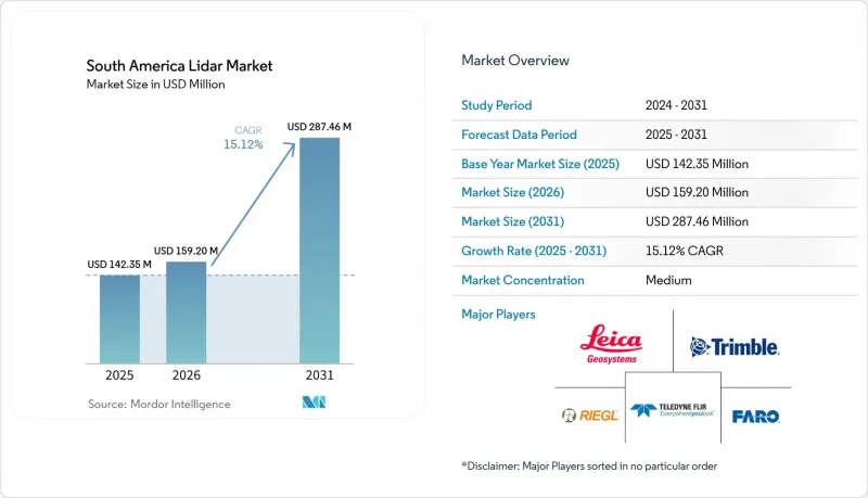
據 Mordor Intelligence 稱,南美洲雷射雷達市場預計將從 2025 年的 1.4235 億美元成長到 2026 年的 1.5914 億美元,到 2031 年達到 3.2173 億美元,預計 2026 年至 2031 年的複合成長率為 15.12%。
南美LiDAR市場趨勢與洞察
利用無人機擴大測繪作業
搭載於遠程無人機上的輕型雷射雷達有效載荷正在降低每公頃的測繪成本,並改善偏遠地區的測繪條件。在巴西戈亞斯州的一座銅金礦中,一架配備Zenmuse L3雷射雷達系統的DJI Matrice 400無人機實現了3公分的測繪精度。與地面GNSS RTK方法相比,該專案將執行時間縮短了50%,並且可以在不中斷運作中作業的情況下完成。在一個橫跨巴西四個州的184公里鐵路測繪計畫中,機載雷射雷達展現了其在鐵路走廊測繪方面的強大能力,即使在地面難以到達的區域也能勝任。快速部署的能力使當地業者能夠承接以前難以完成的小規模專案。
採礦和林業對高精度地形資料的需求
採礦、林業及相關合規活動持續推動南美雷射雷達市場的需求。這些活動需要地形資料進行安全評估、體積測量和環境記錄。預計到2025年,智利將部署移動式雷射雷達掃描技術,用於礦床和尾礦的3D監測。在許多礦區和林區,茂密的植被使得傳統的攝影測量方法難以發揮作用。LiDAR可以識別植被下的地形特徵,從而實現更全面的場地評估。因此,採購計劃與合規進度和商品投資週期緊密相關。
高昂的初始設定成本和後處理成本
測量級航空測量系統整合了雷射掃描儀、全球導航衛星系統 (GNSS)、慣性測量單元 (IMU) 和處理軟體。進口設備的價格通常在 10 萬至 30 萬美元之間。對於許多本地服務公司和公共機構而言,如此龐大的資本投資難以負擔。此外,後處理需要正版軟體、訓練有素的人員以及嚴格的品管程序。在植被茂密的地區,地形分類和模型生成會變得更加複雜。雖然資料即服務(DaaS) 合約可以降低初始設備成本,但這可能會導致處理能力集中在少數營運商手中。
細分市場分析
預計到2025年,機載雷射雷達將佔銷售額的34.00%,並繼續保持其在南美雷射雷達市場的領先地位。航空數據採集非常適合穿越熱帶森林冠層和安第斯山脈的大規模測繪,並且可以覆蓋道路通行和地面測繪困難的大片區域。 2026年4月,Hexagon R-evolution將在淡水河谷的阿瓜斯克拉拉斯礦區執行一項恢復任務。該計畫將使用徠卡測量系統的混合機載測繪系統,以每平方公尺超過40個點的密度繪製超過20平方公里的區域,以支援礦山資產管理。地面、移動和固定地面系統可用於封閉的工業設施、都市區和地下礦井。這些固定掃描方法能夠實現詳細的結構記錄。
用於水文測量的LiDAR市場預計到2031年將以18.50%的複合年成長率成長,成為南美LiDAR市場中成長最快的產品類型。這一成長主要由近海和沿海測繪需求驅動。預計巴西大西洋沿岸將在短期內成為海上能源活動的重要樞紐。 2026年4月,Fugro公司預計將贏得巴西石油公司(Petrobras)的契約,負責巴西里約熱內盧18兆瓦海上風電先導計畫的地質勘測工作。該計畫預計將成為南美洲首個正式進入巴西環境與可再生自然資源研究所(IBAMA)許可程序的離岸風電開發計畫。勘測工作計劃於2026年4月至第三季進行。該合約表明,沿海開發將持續產生對水文測量數據和沿海地區數據的需求。
預計到2025年,雷射掃描儀將佔組件銷售額的40.00%,並預計在南美洲的雷射雷達市場佔據最大的組件佔有率。發送器-偵測器組件通常是雷射雷達配置中最昂貴的子系統,並決定著點密度、測距範圍和精度等關鍵性能指標。徠卡測量系統預計將於2026年6月推出其地面掃描器RTC300、RTC500和RTC700。此系列產品將具備與Hexagon GeoCloud進行Livelink資料流傳輸的功能,體現了徠卡測量系統對基礎設施和數位孿生工作流程地面掃描技術的持續投入。 GNSS和相機仍將是整合系統中重要的輔助組件。
預計到2031年,慣性測量單元(IMU)市場將以16.20%的複合年成長率成長,成為成長最快的組件類別。無人機平台需要在飛行過程中精確校正橫滾、俯仰和偏航,而精確的軌跡資料對於維持公分級點雲品質至關重要。這項要求在樹冠穿透和走廊測繪任務中變得日益關鍵。 YellowScan計畫於2026年2月推出配備Trimble Applanix APX-RTX IMU的「Venturer」無人機。該系統將姿態測量精度作為選擇無人機LiDAR的關鍵考慮因素。增強的運動校正功能使操作人員即使在不斷變化的飛行條件下也能保持數據品質的一致性。
其他好處:
- Excel格式的市場預測(ME)表
- 3個月的分析師支持
目錄
第1章:引言
- 研究假設和市場定義
- 調查範圍
第2章:調查方法
第3章執行摘要
第4章 市場狀況
- 市場概覽
- 宏觀經濟因素對市場的影響
- 市場促進因素
- 利用無人機和無人飛行器擴展測繪技術
- 基礎設施數位化和數位孿生技術的引入
- 採礦和林業對高精度地形資料的需求
- 政府主導的環境與災害監測計劃
- 亞馬遜對碳計量和生物多樣性監測的要求
- 基於特許經營的資產檢查和LiDAR資料即服務(DaaS) 模式
- 市場限制因素
- 高昂的採集和後處理成本
- 對成本高度敏感的汽車市場以及ADAS的低普及率
- 進口依賴性、關稅和外匯波動
- 缺乏本地LiDAR資料處理和校準方面的專業知識。
- 產業價值鏈分析
- 監理情勢
- 技術展望
- 波特五力分析
第5章 市場規模及成長預測、價值及銷售
- 依產品類型
- 航空LiDAR
- 地面LiDAR
- 移動LiDAR
- 用於測深的LiDAR
- 地面固定式雷射雷達
- 按組件
- 雷射掃描儀
- GPS和GNSS接收器
- 慣性測量單元
- 相機和成像模組
- 計算和計時電子學
- 其他規則
- 透過技術
- 機械LiDAR
- 固態雷射雷達
- 混合LiDAR
- 飛行時間LiDAR
- 調頻連續波LiDAR
- 按範圍
- 短距離(小於200公尺)
- 中距離,200-500米
- 長距離(500公尺或以上)
- 按安裝類型
- 機上
- 地面安裝型(固定型)
- 地面移動
- 配備無人機的
- 透過使用
- 採礦和探勘
- 基礎建設和城市規劃
- 農業和林業
- 政府和公共機構
- 環境/保護
- 電力線路巡檢
- 石油和天然氣資產檢查
- 其他用途
- 按地區
- 巴西
- 阿根廷
- 智利
- 其他南美國家
第6章 競爭情勢
- 市場集中度
- 策略趨勢
- 市佔率分析
- 公司簡介
- Leica Geosystems AG
- Trimble Inc.
- Teledyne Technologies Incorporated
- FARO Technologies, Inc.
- RIEGL Laser Measurement Systems GmbH
- SICK AG
- Hexagon AB
- YellowScan
- Topcon Corporation
- TerraSolid Ltd.
- Ouster, Inc.
- Innoviz Technologies Ltd.
- Hesai Group
- RoboSense Technology Co., Ltd.
- LeddarTech Inc.
- DENSO Corporation
- XMobots Aeroespacial e Sistemas SA
- Santos Lab Comercio e Industria Aeroespacial Ltda.
- Quantum Spatial, Inc.
- Fugro NV
第7章 市場機會與未來展望
According to Mordor Intelligence, the South America lidar market size is expected to increase from USD 142.35 million in 2025 to USD 159.14 million in 2026 and reach USD 321.73 million by 2031, growing at a CAGR of 15.12% over 2026-2031.
South America Lidar Market Trends and Insights
Expansion of UAV and Drone-Based Surveying
Lightweight LiDAR payloads deployed on longer-endurance drones reduce survey costs per hectare and improve access to remote sites. At a copper-gold mine in Goias, Brazil, a DJI Matrice 400 equipped with a Zenmuse L3 LiDAR system achieved 3 cm accuracy. The project reduced execution time by 50% compared with ground-based GNSS RTK methods and proceeded without disrupting active mining operations. A 184 km railway mapping project across four Brazilian states demonstrated that aerial LiDAR can support corridor surveys in areas that are difficult to access from the ground. Faster mobilization enables regional operators to compete for smaller assignments that were previously more challenging to serve.
Mining and Forestry Demand for High-Precision Terrain Data
Mining, forestry, and related compliance activities generate recurring demand in the South American LiDAR market. These activities require terrain data for safety assessments, volume measurements, and environmental documentation. In 2025. Chile is expected to adopt mobile LiDAR scanning for 3D monitoring of mine deposits and tailings. Dense canopy cover reduces the effectiveness of conventional photogrammetry across many mining and forestry sites. LiDAR can identify terrain features beneath vegetation, enabling more comprehensive site assessments. Consequently, procurement is tied to compliance schedules and commodity investment cycles.
High Acquisition and Post-Processing Costs
Survey-grade aerial systems integrate laser scanners, GNSS, IMUs, and processing software. Imported units typically cost between USD 100,000 and USD 300,000. Many regional service firms and public agencies cannot easily finance such significant equipment investments. Processing also requires licensed software, trained personnel, and rigorous quality-control procedures. Dense canopy further increases the complexity of classification and terrain-model generation. Although data-as-a-service contracts reduce upfront equipment costs, they may concentrate capacity among a limited number of operators.
Other drivers and restraints analyzed in the detailed report include:
- Infrastructure Digitization and Digital-Twin Deployment
- Government-Led Environmental and Disaster-Monitoring Programs
- Import Dependence, Duties, and Currency Volatility
For complete list of drivers and restraints, kindly check the Table Of Contents.
Segment Analysis
Aerial LiDAR is projected to account for 34.00% of revenue in 2025, maintaining its leading position in the South America LiDAR market. Airborne acquisition is well suited for large-scale surveys across tropical canopies and Andean terrain, providing broad coverage in areas where road access and ground surveying are challenging. In April 2026, Hexagon R-evolution is scheduled to conduct a rehabilitation mission at Vale's Aguas Claras mine. The project will map more than 20 square kilometers at a density exceeding 40 points per square meter, using Leica Geosystems' hybrid airborne system to support mining asset management. Ground-based, mobile, and terrestrial static systems serve confined industrial facilities, urban areas, and underground mines. Their fixed scan geometry supports detailed structural documentation.
Bathymetric LiDAR is projected to grow at a CAGR of 18.50% through 2031, the fastest rate among product types in the South America LiDAR market. Offshore and nearshore survey requirements support this growth segment. Brazil's Atlantic coast is expected to be the primary near-term source of offshore energy activity. In April 2026, Fugro is expected to receive a Petrobras contract for geotechnical investigations for Brazil's 18 MW Rio de Janeiro offshore wind pilot project. The project is expected to become the first South American offshore wind development to enter formal environmental licensing with the Brazilian Institute of Environment and Renewable Natural Resources (IBAMA). Survey work is scheduled to take place from April through the third quarter of 2026. This contract demonstrates how coastal development can generate recurring demand for bathymetric and nearshore data.
Laser scanners are projected to account for 40.00% of component revenue in 2025, representing the largest share of the South America LiDAR market by component. The emitter-detector assembly often represents the highest-value subsystem in a LiDAR configuration and determines key performance metrics, including point density, range, and accuracy. Leica Geosystems is expected to launch the RTC300, RTC500, and RTC700 terrestrial scanners in June 2026. The series will include Livelink streaming to Hexagon GeoCloud, reflecting continued investment in terrestrial scanning for infrastructure and digital twin workflows. GNSS and cameras will remain important supporting components in integrated systems.
IMUs are projected to grow at a CAGR of 16.20% through 2031, making them the fastest-growing component group. Drone platforms require precise roll, pitch, and yaw compensation during flight, while accurate trajectory data is essential to maintain centimeter-level point-cloud quality. This requirement becomes increasingly important in canopy-penetration and corridor-mapping missions. YellowScan is expected to introduce the Venturer in February 2026, featuring a Trimble Applanix APX-RTX IMU. The system positions orientation quality as a key consideration in UAV LiDAR selection. Enhanced motion compensation helps operators maintain consistent data quality across changing flight conditions.
Complete Report Scope:
- By Product Type
- Aerial LiDAR
- Ground-Based LiDAR
- Mobile LiDAR
- Bathymetric LiDAR
- Terrestrial Static LiDAR
- By Component
- Laser Scanners
- GPS and GNSS Receivers
- Inertial Measurement Units
- Cameras and Imaging Modules
- Computing and Timing Electronics
- Other Components
- By Technology
- Mechanical LiDAR
- Solid-State LiDAR
- Hybrid LiDAR
- Time-of-Flight LiDAR
- Frequency-Modulated Continuous-Wave LiDAR
- By Range
- Short Range, Less Than 200 Meters
- Medium Range, 200-500 Meters
- Long Range, More Than 500 Meters
- By Installation
- Airborne
- Ground-Based Static
- Ground-Based Mobile
- UAV-Mounted
- By Application
- Mining & Exploration
- Infrastructure & Urban Planning
- Agriculture & Forestry
- Government & Public Agencies
- Environment & Conservation
- Power Transmission-Line Inspection
- Oil & Gas Asset Inspection
- Other Applications
- by Geography
- Brazil
- Argentina
- Chile
- Rest of South America
List of Companies Covered in this Report:
- Leica Geosystems AG
- Trimble Inc.
- Teledyne Technologies Incorporated
- FARO Technologies, Inc.
- RIEGL Laser Measurement Systems GmbH
- SICK AG
- Hexagon AB
- YellowScan
- Topcon Corporation
- TerraSolid Ltd.
- Ouster, Inc.
- Innoviz Technologies Ltd.
- Hesai Group
- RoboSense Technology Co., Ltd.
- LeddarTech Inc.
- DENSO Corporation
- XMobots Aeroespacial e Sistemas S.A.
- Santos Lab Comercio e Industria Aeroespacial Ltda.
- Quantum Spatial, Inc.
- Fugro N.V.
Additional Benefits:
- The market estimate (ME) sheet in Excel format
- 3 months of analyst support
TABLE OF CONTENTS
1 INTRODUCTION
- 1.1 Study Assumptions and Market Definition
- 1.2 Scope of the Study
2 RESEARCH METHODOLOGY
3 EXECUTIVE SUMMARY
4 MARKET LANDSCAPE
- 4.1 Market Overview
- 4.2 Impact of Macroeconomic Factors on the Market
- 4.3 Market Drivers
- 4.3.1 Expansion of UAV and Drone-Based Surveying
- 4.3.2 Infrastructure Digitization and Digital-Twin Deployment
- 4.3.3 Mining and Forestry Demand for High-Precision Terrain Data
- 4.3.4 Government-Led Environmental and Disaster-Monitoring Programs
- 4.3.5 Amazon Carbon-Accounting and Biodiversity-Monitoring Requirements
- 4.3.6 Concession-Based Asset Inspection and LiDAR Data-as-a-Service Models
- 4.4 Market Restraints
- 4.4.1 High Acquisition and Post-Processing Costs
- 4.4.2 Cost-Sensitive Automotive Market and Limited ADAS Penetration
- 4.4.3 Import Dependence, Duties, and Currency Volatility
- 4.4.4 Shortage of Local LiDAR Processing and Calibration Expertise
- 4.5 Industry Value Chain Analysis
- 4.6 Regulatory Landscape
- 4.7 Technological Outlook
- 4.8 Porter's Five Forces Analysis
- 4.8.1 Threat of New Entrants
- 4.8.2 Bargaining Power of Buyers
- 4.8.3 Bargaining Power of Suppliers
- 4.8.4 Threat of Substitute Technologies
- 4.8.5 Intensity of Competitive Rivalry
5 MARKET SIZE AND GROWTH FORECASTS, VALUE AND VOLUME
- 5.1 By Product Type
- 5.1.1 Aerial LiDAR
- 5.1.2 Ground-Based LiDAR
- 5.1.3 Mobile LiDAR
- 5.1.4 Bathymetric LiDAR
- 5.1.5 Terrestrial Static LiDAR
- 5.2 By Component
- 5.2.1 Laser Scanners
- 5.2.2 GPS and GNSS Receivers
- 5.2.3 Inertial Measurement Units
- 5.2.4 Cameras and Imaging Modules
- 5.2.5 Computing and Timing Electronics
- 5.2.6 Other Components
- 5.3 By Technology
- 5.3.1 Mechanical LiDAR
- 5.3.2 Solid-State LiDAR
- 5.3.3 Hybrid LiDAR
- 5.3.4 Time-of-Flight LiDAR
- 5.3.5 Frequency-Modulated Continuous-Wave LiDAR
- 5.4 By Range
- 5.4.1 Short Range, Less Than 200 Meters
- 5.4.2 Medium Range, 200-500 Meters
- 5.4.3 Long Range, More Than 500 Meters
- 5.5 By Installation
- 5.5.1 Airborne
- 5.5.2 Ground-Based Static
- 5.5.3 Ground-Based Mobile
- 5.5.4 UAV-Mounted
- 5.6 By Application
- 5.6.1 Mining & Exploration
- 5.6.2 Infrastructure & Urban Planning
- 5.6.3 Agriculture & Forestry
- 5.6.4 Government & Public Agencies
- 5.6.5 Environment & Conservation
- 5.6.6 Power Transmission-Line Inspection
- 5.6.7 Oil & Gas Asset Inspection
- 5.6.8 Other Applications
- 5.7 by Geography
- 5.7.1 Brazil
- 5.7.2 Argentina
- 5.7.3 Chile
- 5.7.4 Rest of South America
6 COMPETITIVE LANDSCAPE
- 6.1 Market Concentration
- 6.2 Strategic Moves
- 6.3 Market Share Analysis
- 6.4 Company Profiles (includes Global Level Overview, Market Level Overview, Core Segments, Financials as available, Strategic Information, Market Rank/Share, Products and Services, Recent Developments)
- 6.4.1 Leica Geosystems AG
- 6.4.2 Trimble Inc.
- 6.4.3 Teledyne Technologies Incorporated
- 6.4.4 FARO Technologies, Inc.
- 6.4.5 RIEGL Laser Measurement Systems GmbH
- 6.4.6 SICK AG
- 6.4.7 Hexagon AB
- 6.4.8 YellowScan
- 6.4.9 Topcon Corporation
- 6.4.10 TerraSolid Ltd.
- 6.4.11 Ouster, Inc.
- 6.4.12 Innoviz Technologies Ltd.
- 6.4.13 Hesai Group
- 6.4.14 RoboSense Technology Co., Ltd.
- 6.4.15 LeddarTech Inc.
- 6.4.16 DENSO Corporation
- 6.4.17 XMobots Aeroespacial e Sistemas S.A.
- 6.4.18 Santos Lab Comercio e Industria Aeroespacial Ltda.
- 6.4.19 Quantum Spatial, Inc.
- 6.4.20 Fugro N.V.
7 MARKET OPPORTUNITIES AND FUTURE OUTLOOK
- 7.1 White-Space and Unmet-Need Assessment

 LiDAR市場預測(2034 年)—按技術類型、組件、測量範圍、波長、應用、最終用戶和地區分類的全球分析
 W波段毫米波雲觀測雷達市場:全球市場預測(2026-2032年)線點LiDAR發射模組市場:全球市場預測,2026-2032年2026年全球LiDAR競爭情報-關鍵參與者、技術趨勢、製造、創新與競爭格局的策略分析2026年全球雷射雷達專利情報-專利格局、應用趨勢、主要專利持有人策略分析、技術領域、閒置頻段及未來智慧財產權展望
 中東和非洲雷射雷達市場:市場佔有率分析、行業趨勢和統計數據以及成長預測(2026-2031 年)
 風力發電雷射雷達市場:按類型、安裝配置、測量範圍、應用、最終用戶、國家及地區分類-全球產業分析、市場規模、市場佔有率及2026年至2033年預測北美雷射雷達:市場佔有率分析、產業趨勢與統計及成長預測(2026-2031 年)歐洲雷射雷達:市場佔有率分析、產業趨勢與統計及成長預測(2026-2031 年)LiDAR市場-2026-2032年全球市場預測