


 |
市場調查報告書
商品編碼
2121873
中東和非洲雷射雷達市場:市場佔有率分析、行業趨勢和統計數據以及成長預測(2026-2031 年)Middle East And Africa LiDAR - Market Share Analysis, Industry Trends & Statistics, Growth Forecasts (2026 - 2031) |
||||||

※ 本網頁內容可能與最新版本有所差異。詳細情況請與我們聯繫。
根據 Mordor Intelligence 預測,中東和非洲的雷射雷達市場規模預計將從 2025 年的 4.1 億美元成長到 2026 年的 4.557 億美元,然後從 2026 年到 2031 年以 11.15% 的複合成長率成長,到 2031 億美元達到 7.7.79 億美元。
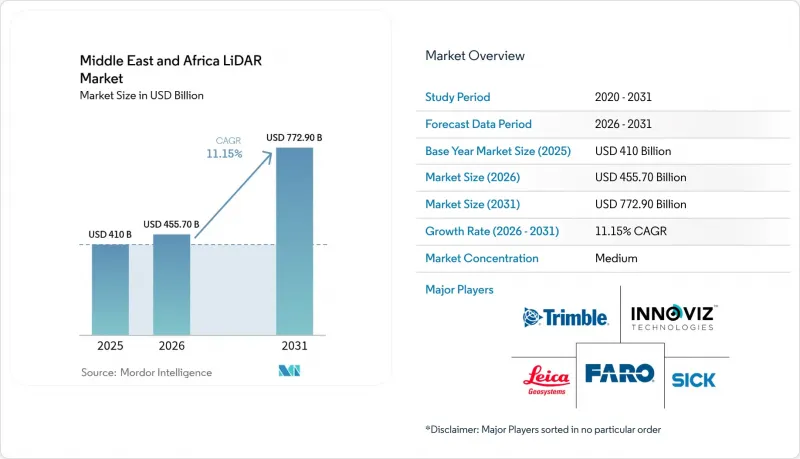
本報告按產品(機載雷射雷達、地面雷射雷達等)、技術(飛行時間法、蓋格模式等)、組件(雷射掃描儀、GPS等)、部署平台(無人機平台等)、測量範圍(短程等)、最終用戶產業(工程等)和國家(沙烏地阿拉伯等)進行細分。市場規模和預測均以美元計價。
中東和非洲雷射雷達市場趨勢與洞察
海灣合作理事會強制部署雷射雷達以建造智慧城市數位孿生體
海灣國家政府目前正強制要求對城市資產進行亞厘米級精度的數位化建模,這使得雷射雷達(LiDAR)成為繪製地下管線、最佳化交通流量和分析碳足跡的關鍵技術。杜拜市政府正在使用行動掃描器對埋地管道和電纜進行建模,從而減少意外停電和返工。在卡達,盧賽爾市斥資6,000萬美元打造的智慧城市平台持續處理LiDAR數據,為45萬居民提供公共服務。公共專案中強制實施BIM(建築資訊模型)確保雷射雷達點雲資料能夠直接整合到標準化的施工模型中,從而消除資料格式瓶頸。這最終形成了一種統一的規劃方法,加快了核准流程,並降低了專案生命週期成本超支。海灣合作理事會(GCC)成員國政府也在採購LiDAR並結合雲端分析技術,推廣使用符合主權法規的當地資料中心。
沙烏地阿拉伯巨型計畫無人機走廊測繪需求激增
對於像NEOM長達170公里的線性城市這樣的大型項目,由於傳統測量方法無法及時覆蓋大片區域,因此需要每週更新地形資料。如今,配備中程雷射雷達的旋翼無人機每天可繪製多達100英畝的地圖,精度達到1-3厘米,從而將進度追蹤週期縮短了70%。像Aeromotus這樣的專業公司提供「無人機即服務」的承包解決方案,將飛行規劃、掃描和雲端處理融為一體。利用由此產生的數位孿生模型,承包商可以將設計意圖與竣工狀態進行對比,並及早發現土方工程偏差。對於高速鐵路和海水淡化管道等線性基礎設施而言,快速更新走廊資訊可以減少變更指令的頻率,並確保按時完成各項交付里程碑。
本地校準實驗室短缺導致前置作業時間延長。
由於利雅德和約翰尼斯堡之間經認證的測試實驗室寥寥無幾,大多數業者被迫將感測器送往歐洲進行年度重新校準。物流延誤可能長達12週,導致施工高峰設備無法正常使用。大型建築公司透過從ClearSkies Geomatics等供應商租賃預校準設備來應對,但中小企業面臨員工閒置和被迫支付罰款的困境。這一瓶頸也阻礙了先進固態雷射雷達的普及,這類雷達通常需要更短的維護週期才能維持其性能指標。儘管沿岸地區的一些自由區已宣佈為海外測量機構開設分店提供激勵措施,但預計在2027年或之後才能確保足夠的處理能力。
細分市場分析
到2025年,空中平台將佔據中東和非洲雷射雷達市場54.30%的佔有率。這主要歸功於其能夠勘測遍布乾旱地形的大型工程現場。沙烏地阿拉伯的工程公司正利用直升機和固定翼飛機進行勘測作業,每週更新土方開挖和填築量,並將數據反映在儀錶板上,以便預警工程延誤。透過將傾斜攝影測量與高密度點雲結合,負責人可以視覺化影響道路路線的岩層和沙漠乾涸河床。在奈米比亞,空中掃描也被用於監測海岸侵蝕,利用綠色波長雷射脈衝測量旅遊海灘沿線沙丘的移動。
雖然地面掃描儀目前市佔率較小,但隨著市政當局對下水道、橋樑和歷史建築外觀進行數位化改造,預計其年複合成長率將達到13.76%。穿戴式系統無需GPS即可繪製多層隧道地圖,使檢查人員能夠檢測到瓷磚後面的混凝土剝落。中東和非洲的雷射雷達市場正受益於即時定位與地圖建構(SLAM)演算法,該演算法能夠即時註冊掃描數據,從而可以在一夜之間產生碰撞檢測報告,而此前則需要一周時間。硬體小型化使得兩名工作人員即可在一夜之間掃描整個地鐵站,從而使高精度文件能夠惠及更廣泛的用戶群體,而不僅僅是大型承包商。
2025年,飛行時間(ToF)分析仍佔銷售額的62.40%,持續維持其核心技術地位。這主要歸功於其即使在阿拉伯半島特有的沙塵暴和強烈陽光下也能保持穩定的性能。電力公司正在使用ToF設備來檢查輸電線路走廊的淨空,避免因植被遮擋而導致的停電,從而保障煉油廠的生產。供應商的藍圖包括推出一款對人眼安全的1550奈米雷射器,將測量範圍擴展至3公里以上,從而拓展其在露天礦邊坡分析中的應用。
由於超高密度測量點加速了環境建模,蓋格模式感測器的年複合成長率預計將達到12.85%。在加彭的森林碳匯計畫中,這項技術正被用於改善生物量估計值,這在自願性碳市場檢驗標準日益嚴格的背景下顯得格外重要。高空作業可達到每小時366平方公里的觀測範圍,只需一次飛機部署即可完成全國性的數位高程模型(DEM)更新。目前正在進行的壓縮感知研究可望在不增加資料量的情況下將解析度提高64倍,從而增強其在即時洪水模擬中的適用性。
其他好處:
- Excel格式的市場預測(ME)表
- 3個月的分析師支持
目錄
第1章:引言
- 研究假設和市場定義
- 調查範圍
第2章:調查方法
第3章執行摘要
第4章 市場狀況
- 市場概覽
- 市場促進因素
- 海灣合作理事會強制部署雷射雷達以建造智慧城市數位孿生體
- 利用無人機進行走廊測繪在沙烏地阿拉伯的超級工程中正迅速普及。
- 奈米比亞和南非沿海的離岸風力發電需要水深測量。
- 在阿拉伯聯合大公國的關鍵設施實施以安全為中心的周界監控
- 露天銅礦和金礦的高解析度地形資料。
- 考慮尼羅河流域氣候變遷適應能力的洪氾區模型
- 市場限制因素
- 由於該地區校準實驗室短缺,前置作業時間較長。
- 對海灣合作理事會以外的非洲國家徵收 3B 類雷射的進口關稅。
- 海灣國家以外地區GNSS參考站密度低
- 衝突後,北非公共部門資本投資停滯不前
- 價值供應鏈分析
- 監管和技術展望
- 波特五力分析
- 投資分析
第5章 市場規模與成長預測
- 依產品
- 航空LiDAR
- 機械掃描
- 固態掃描型
- 透過技術
- 地面LiDAR
- 飛行時間法
- 蓋格模式
- 相移
- 閃光雷射雷達
- 按組件
- 雷射掃描儀
- GPS/GNSS接收器
- 慣性測量單元
- 相機和MEMS鏡
- 其他規則
- 透過部署平台
- 地面安裝式三腳架
- 無人機/無人飛行器基地
- 移動式製圖(車載式)
- 水深測量/航空水文測量
- 按範圍
- 短距離
- 中距離
- 長途
- 按最終用途行業分類
- 工程與施工
- 石油和天然氣
- 航太/國防
- 汽車/ADAS
- 採礦和採石
- 農業和林業
- 國家
- 沙烏地阿拉伯
- 卡達
- 科威特
- 阿拉伯聯合大公國
- 南非
- 肯亞
- 其他中東和非洲國家
第6章 競爭情勢
- 市場集中度
- 策略趨勢
- 市佔率分析
- 公司簡介
- Leica Geosystems AG
- Sick AG
- Ouster Inc.
- Cepton Technologies Inc.
- Hexagon AB
- MENA 3D
- Sandvik Mining and Rock Solutions
- Trimble Inc.
- FARO Technologies Inc.
- RIEGL Laser Measurement Systems
- Quanergy Systems Inc.
- LightWare LiDAR LLC
- GlobalScan Technologies LLC
- Microdrones GmbH
- Innoviz Technologies Ltd
- Velodyne Lidar Inc.
- Teledyne Optech
- Topcon Positioning Group
- Falcon-3D
- Sitech Gulf
- DJI Enterprise
第7章 市場機會與未來展望
According to Mordor Intelligence, the Middle East and Africa LiDAR market size is expected to grow from USD 410 million in 2025 to USD 455.7 million in 2026 and is forecast to reach USD 772.9 million by 2031 at 11.15% CAGR over 2026-2031.
This report is Segmented by Product (Aerial LiDAR, Ground-Based and More), Technology (Time-Of-Flight, Geiger-Mode and More), Component (Laser Scanners, GPS and More), Deployment Platform (UAV-Based, and More), Range (Short-Range, and More), End-Use Industry (Engineering, and More), and Country (Saudi Arabia, and More). The Market Size and Forecasts are Provided in Terms of Value (USD).
Middle East And Africa LiDAR Market Trends and Insights
LiDAR Mandate for Smart-City Digital Twins in GCC
Gulf governments now require sub-centimeter digital replicas of city assets, making LiDAR indispensable for underground-utility mapping, traffic-flow optimisation, and carbon-footprint analysis. Dubai Municipality is applying mobile scanners to model buried pipes and cables, cutting unplanned outages and excavation re-works. In Qatar, a USD 60 million smart-city platform for Lusail City processes continuous LiDAR feeds to manage 450,000 residents' services. Mandatory BIM adoption in public projects ensures that LiDAR point clouds flow directly into standardised construction models, removing data-format bottlenecks. The result is a unified planning approach that speeds permit approvals and reduces lifecycle cost overruns. GCC authorities also bundle LiDAR procurement with cloud analytics, encouraging local data-centres that comply with sovereignty rules.
Surge in UAV-Borne Corridor Mapping for Saudi Giga-Projects
High-profile programmes such as NEOM's 170 km linear city require weekly topographic updates over vast tracts that conventional surveys cannot cover in time. Rotary-wing drones equipped with medium-range LiDAR now map up to 100 acres per day at 1-3 cm accuracy, slashing progress-tracking cycles by 70%. Specialist operators like Aeromotus supply turnkey drone-as-a-service packages that combine flight planning, scanning, and cloud processing. Resulting digital twins allow contractors to compare design intent with as-built conditions, catching earthwork deviations early. For linear infrastructure such as high-speed rail spines and desalination pipelines, rapid corridor updates reduce change-order frequency and safeguard delivery milestones.
Scarcity of Regional Calibration Labs Inflating Lead-Times
Only a handful of accredited laboratories exist between Riyadh and Johannesburg, forcing most operators to ship sensors to Europe for annual recalibration. Logistics lags can stretch to 12 weeks, freezing fleet availability during peak construction phases. Larger contractors respond by leasing pre-calibrated units from providers such as ClearSkies Geomatics, while smaller firms idle crews and absorb liquidated damages. The bottleneck also hampers adoption of advanced solid-state LiDAR, which often requires shorter service cycles to uphold warranty specifications. Several Gulf free-zones have announced incentives for foreign metrology houses to open branches, yet timelines suggest meaningful capacity will not arrive before 2027.
Other drivers and restraints analyzed in the detailed report include:
- Offshore Wind-Farm Bathymetry Needs Off Namibia and South Africa
- Security-Driven Perimeter Surveillance at UAE Critical Sites
- Limited GNSS Reference-Station Density Outside Gulf States
For complete list of drivers and restraints, kindly check the Table Of Contents.
Segment Analysis
Aerial platforms generated 54.30% of the Middle East and Africa LiDAR market size in 2025, a position rooted in their ability to survey giga-project footprints that sprawl across arid terrains. Saudi engineering firms rely on helicopter and fixed-wing campaigns to update cut-and-fill quantities weekly, feeding dashboards that flag schedule slippage. The combination of oblique photogrammetry with high-density point clouds helps planners visualise rock-cut faces and desert wadis that influence road alignments. Aerial scanning also underpins coastal-erosion monitoring in Namibia, where green-wavelength laser pulses measure dune migration along tourist beaches.
Ground-based scanners, though holding a smaller share, are slated for 13.76% CAGR as municipalities digitise sewers, bridges, and heritage facades. Wearable systems map multistorey tunnels without GPS, letting inspectors detect spalling concrete behind tiles. The Middle East and Africa LiDAR market benefits from SLAM algorithms that register scans in real time, permitting overnight issuance of clash-detection reports that would once take a week. Hardware miniaturisation means a two-person crew can now capture an entire metro station in an evening, democratising high-precision documentation beyond tier-one contractors.
Time-of-Flight remained the workhorse with 62.40% revenue in 2025, prized for robust performance under dust-laden winds and intense solar glare typical of the Arabian Peninsula. Power utilities employ ToF units for corridor clearance checks on transmission lines, avoiding vegetation-related outages that could stall refinery production. Vendor roadmaps introduce eye-safe 1,550 nm lasers that extend range past 3 km, widening use in open-pit mine slope analysis.
Geiger-mode sensors post a 12.85% CAGR forecast because ultra-high-point densities accelerate environmental modelling. Forestry-carbon projects in Gabon use the technology to refine biomass estimates, an attractive quality as voluntary carbon markets tighten verification standards. Elevated altitude operation supports 366 km2/h coverage, enabling national-scale DEM refreshes on single aircraft sorties. Continued research into compressive sensing promises 64-fold resolution gains without heavier data volumes, enhancing suitability for real-time flood simulations.
Complete Report Scope:
- By Product
- Aerial LiDAR
- Mechanical Scanning
- Solid-state Scanning
- By Technology
- Ground-based LiDAR
- Time-of-Flight
- Geiger-Mode
- Phase-Shift
- Flash LiDAR
- By Component
- Laser Scanners
- GPS/GNSS Receiver
- Inertial Measurement Unit
- Cameras and MEMS Mirrors
- Other Components
- By Deployment Platform
- Terrestrial Static Tripod
- UAV-/Drone-based
- Mobile Mapping (Vehicle-mounted)
- Bathymetric/Airborne Hydrographic
- By Range
- Short-Range
- Medium-Range
- Long-Range
- By End-Use Industry
- Engineering and Construction
- Oil and Gas
- Aerospace and Defense
- Automotive and ADAS
- Mining and Quarrying
- Agriculture and Forestry
- By Country
- Saudi Arabia
- Qatar
- Kuwait
- United Arab Emirates
- South Africa
- Kenya
- Rest of Middle East and Africa
List of Companies Covered in this Report:
- Leica Geosystems AG
- Sick AG
- Ouster Inc.
- Cepton Technologies Inc.
- Hexagon AB
- MENA 3D
- Sandvik Mining and Rock Solutions
- Trimble Inc.
- FARO Technologies Inc.
- RIEGL Laser Measurement Systems
- Quanergy Systems Inc.
- LightWare LiDAR LLC
- GlobalScan Technologies LLC
- Microdrones GmbH
- Innoviz Technologies Ltd
- Velodyne Lidar Inc.
- Teledyne Optech
- Topcon Positioning Group
- Falcon-3D
- Sitech Gulf
- DJI Enterprise
Additional Benefits:
- The market estimate (ME) sheet in Excel format
- 3 months of analyst support
TABLE OF CONTENTS
1 INTRODUCTION
- 1.1 Study Assumptions and Market Definition
- 1.2 Scope of the Study
2 RESEARCH METHODOLOGY
3 EXECUTIVE SUMMARY
4 MARKET LANDSCAPE
- 4.1 Market Overview
- 4.2 Market Drivers
- 4.2.1 LiDAR mandate for smart-city digital twins in GCC
- 4.2.2 Surge in UAV-borne corridor mapping for Saudi giga-projects
- 4.2.3 Offshore wind-farm bathymetry needs off Namibia and South Africa
- 4.2.4 Security-driven perimeter surveillance at UAE critical sites
- 4.2.5 High-resolution topography for copper and gold open-pit mines
- 4.2.6 Climate-resilience flood-plain modelling across Nile basin
- 4.3 Market Restraints
- 4.3.1 Scarcity of regional calibration labs inflating lead-times
- 4.3.2 Customs duties on Class-3B laser imports in non-GCC Africa
- 4.3.3 Limited GNSS reference-station density outside Gulf states
- 4.3.4 Low public-sector CAPEX in post-conflict North Africa
- 4.4 Value / Supply-Chain Analysis
- 4.5 Regulatory and Technological Outlook
- 4.6 Porter's Five Forces Analysis
- 4.6.1 Threat of New Entrants
- 4.6.2 Bargaining Power of Buyers
- 4.6.3 Bargaining Power of Suppliers
- 4.6.4 Threat of Substitute Products
- 4.6.5 Intensity of Competitive Rivalry
- 4.7 Investment Analysis
5 MARKET SIZE AND GROWTH FORECASTS (VALUE)
- 5.1 By Product
- 5.1.1 Aerial LiDAR
- 5.1.2 Mechanical Scanning
- 5.1.3 Solid-state Scanning
- 5.2 By Technology
- 5.2.1 Ground-based LiDAR
- 5.2.2 Time-of-Flight
- 5.2.3 Geiger-Mode
- 5.2.4 Phase-Shift
- 5.2.5 Flash LiDAR
- 5.3 By Component
- 5.3.1 Laser Scanners
- 5.3.2 GPS/GNSS Receiver
- 5.3.3 Inertial Measurement Unit
- 5.3.4 Cameras and MEMS Mirrors
- 5.3.5 Other Components
- 5.4 By Deployment Platform
- 5.4.1 Terrestrial Static Tripod
- 5.4.2 UAV-/Drone-based
- 5.4.3 Mobile Mapping (Vehicle-mounted)
- 5.4.4 Bathymetric/Airborne Hydrographic
- 5.5 By Range
- 5.5.1 Short-Range
- 5.5.2 Medium-Range
- 5.5.3 Long-Range
- 5.6 By End-Use Industry
- 5.6.1 Engineering and Construction
- 5.6.2 Oil and Gas
- 5.6.3 Aerospace and Defense
- 5.6.4 Automotive and ADAS
- 5.6.5 Mining and Quarrying
- 5.6.6 Agriculture and Forestry
- 5.7 By Country
- 5.7.1 Saudi Arabia
- 5.7.2 Qatar
- 5.7.3 Kuwait
- 5.7.4 United Arab Emirates
- 5.7.5 South Africa
- 5.7.6 Kenya
- 5.7.7 Rest of Middle East and Africa
6 COMPETITIVE LANDSCAPE
- 6.1 Market Concentration
- 6.2 Strategic Moves
- 6.3 Market Share Analysis
- 6.4 Company Profiles (includes Global Level Overview, Market Level Overview, Core Segments, Financials as available, Strategic Information, Market Rank/Share for key companies, Products and Services, and Recent Developments)
- 6.4.1 Leica Geosystems AG
- 6.4.2 Sick AG
- 6.4.3 Ouster Inc.
- 6.4.4 Cepton Technologies Inc.
- 6.4.5 Hexagon AB
- 6.4.6 MENA 3D
- 6.4.7 Sandvik Mining and Rock Solutions
- 6.4.8 Trimble Inc.
- 6.4.9 FARO Technologies Inc.
- 6.4.10 RIEGL Laser Measurement Systems
- 6.4.11 Quanergy Systems Inc.
- 6.4.12 LightWare LiDAR LLC
- 6.4.13 GlobalScan Technologies LLC
- 6.4.14 Microdrones GmbH
- 6.4.15 Innoviz Technologies Ltd
- 6.4.16 Velodyne Lidar Inc.
- 6.4.17 Teledyne Optech
- 6.4.18 Topcon Positioning Group
- 6.4.19 Falcon-3D
- 6.4.20 Sitech Gulf
- 6.4.21 DJI Enterprise
7 MARKET OPPORTUNITIES AND FUTURE OUTLOOK
- 7.1 White-space and Unmet-Need Assessment

 風力發電雷射雷達市場:按類型、安裝配置、測量範圍、應用、最終用戶、國家及地區分類-全球產業分析、市場規模、市場佔有率及2026年至2033年預測
 北美雷射雷達:市場佔有率分析、產業趨勢與統計及成長預測(2026-2031 年)歐洲雷射雷達:市場佔有率分析、產業趨勢與統計及成長預測(2026-2031 年)
 LiDAR市場-2026-2032年全球市場預測
 LiDAR半導體市場預測至2034年-全球分析(按半導體類型、波長、LiDAR類型、技術、組件整合、最終用戶和地區分類)
 LiDAR市場機會、成長促進因素、產業趨勢分析及2026-2035年預測。
 風力發電雷射雷達系統市場規模、佔有率及成長分析:依系統結構設定、測量方法、主要商業應用、終端用戶產業、通路及地區分類-2026-2033年產業預測
 風力發電雷射雷達市場-全球產業規模、佔有率、趨勢、機會、預測:依部署方式、應用、技術、範圍、地區和競爭格局分類,2021-2031年光學檢測與測距市場預測至2034年-全球按類型、組件、測量距離、安裝、服務、技術、應用和地區分類的分析
 LiDAR測繪市場分析及預測(至2035年):按類型、產品、服務、技術、組件、應用、部署、最終用戶和功能分類