


 |
市場調查報告書
商品編碼
2120253
歐洲雷射雷達:市場佔有率分析、產業趨勢與統計及成長預測(2026-2031 年)Europe LiDAR - Market Share Analysis, Industry Trends & Statistics, Growth Forecasts (2026 - 2031) |
||||||

※ 本網頁內容可能與最新版本有所差異。詳細情況請與我們聯繫。
據 Mordor Intelligence 稱,歐洲雷射雷達市場預計到 2026 年價值 11.7 億美元,高於 2025 年的 10.1 億美元,預計到 2031 年將達到 24.2 億美元。
預計從 2026 年到 2031 年,其複合年成長率將達到 15.62%。
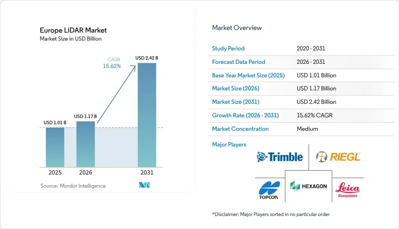
本報告按產品類型(例如,機載雷射雷達、移動/車載雷射雷達)、技術(例如,機械掃描、固態MEMS)、平台(例如,無人機、地面車輛)、終端用戶行業(例如,汽車/交通運輸、土木工程/建築/測繪)和國家/地區進行細分。市場預測以美元計價。
歐洲LiDAR市場趨勢與洞察
Euro-NCAP 2026 基於感測器的安全評估標準正在加速 ADAS(高級駕駛輔助系統)的快速普及。
歐洲新車安全評鑑協會 (Euro-NCAP) 2026 年修訂版協議要求汽車製造商 (OEM) 必須部署冗餘感測系統(包括雷射雷達),以獲得五星評級。德國豪華汽車品牌已將包含遠程雷射雷達的 L3 級駕駛輔助系統商業化,售價超過 5000 歐元,這證實了消費者願意為這項技術買單。監管壓力正在加速部署進程,推動多元化採購策略,並鞏固了 2030 年前高需求的預測。基礎設施供應商也積極跟進,升級測試跑道和認證實驗室以適應多感測器檢驗,而一級供應商則在固態技術藍圖上進行投資,以實現成本降低目標。因此,歐洲LiDAR市場正經歷跨產業的連鎖反應,迫使供應商同時提升產品的耐候性和網路安全合規性。
走廊測繪和數位孿生計畫中無人機雷射雷達的需求
在鐵路、電力和光纖走廊領域,歐洲工程公司正在部署無人機搭載的雷射雷達(LiDAR)來獲取厘米級點雲數據,並將其提供給資產管理平台。例如,RIEGL 的 miniVUX-2UAV 系統每秒可進行 20 萬次測量,以取得植被侵占和邊坡穩定性分析所需的真彩色點雲資料。由於歐盟基於風險的無人機法規能夠快速發放飛行許可,地方政府更傾向於採用基於無人機的工作流程,儘管嚴格的超視距(BVLOS)限制仍然使規劃工作變得複雜。與直升機測繪相比,專案業主發現這種方式顯著節省了成本,而且每季更新資料集的功能也使得建立預測性維護系統成為可能。隨著能源轉型計畫的擴展,走廊測繪的需求為歐洲雷射雷達市場帶來了穩定的需求,供應商們正在努力製定統一的超視距標準以擴大規模。
遠程、高解析度感測器的單價很高
高階車用級雷射雷達的標價仍高達每台3000至10000歐元,而全波形測繪系統的價格則超過10萬歐元,這抑制了對成本敏感的中小企業的需求。隨著中國新參與企業將價格降低了30%至50%,歐洲分銷商的利潤空間受到擠壓,被迫與原始設備製造商(OEM)和政府機構重新談判。為了緩解高價帶來的影響,系統整合商現在開始銷售訂閱模式,將硬體、分析和維護服務打包在多年服務等級協定(SLA)中。政府採購架構除了資本支出外,也開始將總擁有成本(TCO)作為評估標準,並傾向於那些能夠在整個生命週期內實現成本節約的供應商。隨著提案的碳邊境調節措施生效,進口價格優勢逐漸消失,在歐盟內部實現在地化生產的能力將成為一個重要的差異化因素。
細分市場分析
移動/車載雷射雷達佔據歐洲LiDAR市場最大佔有率,預計到2025年將佔總銷售額的46.60%。隨著汽車OEM廠商將遠端感測器整合到L3級自動駕駛系統中,以及物流業者為場內牽引車配備此類設備以實現車輛自動駕駛,移動/車載雷射雷達的應用正在加速普及。移動式製圖車也逐漸成為市政資產管理的主流,一次作業即可採集路緣狀況、街道基礎設施和樹冠覆蓋等數據。深度/海洋雷射雷達正處於快速成長階段,預計到2031年將以16.6%的複合年成長率成長,這主要得益於創紀錄的離岸風力發電租賃協議和沿海韌性提升計畫。採用汽車級固態核心的浮體式平台可將安裝成本降低三分之二,並使以往難以到達的深海域也能進行測量。
成本的趨同正在加速產品類型的重組。隨著固態模組價格降至500美元以下,倉庫AGV和施工機械正成為其主要目標市場,而地面三腳架系統也正從靜態記錄轉向週期性進度追蹤。供應商正透過捆綁SLAM演算法,將背包式掃描器改造為用於文化遺產保護的3D行動採集設備,從而創造出一個利基但永續的收入來源。總體而言,市場需求趨勢明顯偏好能夠穿越複雜環境的系統,這進一步鞏固了移動雷射雷達在歐洲市場的主導地位。
2025年,機械掃描雷射雷達在歐洲市場仍將佔據51.20%的佔有率,這得益於其成熟的測量工作流程和充足的備件庫存。使用者青睞其完善的校準程序和便於現場維護的設計,使其能夠適應嚴苛的作業環境。然而,隨著汽車產業的檢驗完成,以及可擴展封裝顯著降低了單位成本,預計到2031年,FMCW/混合式和其他固態系統將以16.7%的複合年成長率加速成長。 FMCW固有的多普勒特性為防碰撞演算法提供了至關重要的速度數據,其抗干擾能力也解決了多感測器集群中的串擾問題。
在耗資 500 萬歐元的 CoRaLi-DAR 計畫的推動下,歐洲研發部門致力於透過整合式矽光電發送器和 MEMS 光束偏轉器,大幅超越第一代閃光測距系統。同時,軟體創新正利用邊緣人工智慧技術壓縮點雲流,消除頻寬瓶頸。預計汽車固態產品的年出貨量超過 1,000 萬台將迎來轉捩點,並引發對建築和安防領域的連鎖反應。因此,技術格局預計將重新向固態架構傾斜,但機械平台仍將繼續用於超遠程航空測繪,因為目前的固態測距能力尚不足以滿足需求。
其他好處:
- Excel格式的市場預測(ME)表
- 3個月的分析師支持
目錄
第1章:引言
- 研究假設和市場定義
- 調查範圍
第2章:調查方法
第3章執行摘要
第4章 市場狀況
- 市場概覽
- 市場促進因素
- Euro-NCAP 2026 基於感測器的安全評估推動了 ADAS 的快速普及。
- 走廊測繪和數位孿生計畫對無人機LiDAR的需求
- 汽車領域大規模生產帶來的固態裝置成本降低
- 歐盟資助的雷射雷達在智慧城市(交通、空氣污染、人流)部署項目
- 利用浮體式LiDAR系統對離岸風力發電發電廠進行位置評估
- 歐盟強制要求公共工程競標採用BIM 3級數位孿生規範。
- 市場限制因素
- 遠端、高解析度感測器的成本很高。
- 霧、雨、雪天氣下性能下降
- 對超視距無人機飛行有嚴格的規定
- GaAs/SiGe雷射二極體的供應鏈依賴性
- 產業價值鏈分析
- 監理情勢
- 技術展望
- 波特五力分析
- 宏觀經濟趨勢對市場的影響
第5章 市場規模與成長預測
- 依產品類型
- 航空LiDAR
- 移動/汽車LiDAR
- 地面式(三腳架型)LiDAR
- 水深測量/海洋LiDAR
- 透過技術
- 機械掃描
- 固態微機電系統
- 固態快閃記憶體/OPA
- FMCW/混合式
- 按平台
- 無人機/無人飛行器
- 地面車輛
- 手持/背包
- 固定基礎設施
- 船用/艦載型
- 按最終用途行業分類
- 汽車和運輸業
- 工程、建築、測量
- 工業和物流自動化
- 航太/國防
- 環境監測與農業
- 智慧城市和基礎設施
- 其他終端用戶產業
- 國家
- 英國
- 德國
- 法國
- 西班牙
- 義大利
- 荷蘭
- 比利時
- 瑞士
- 其他歐洲國家
第6章 競爭情勢
- 市場集中度
- 策略趨勢
- 市佔率分析
- 公司簡介
- Leica Geosystems AG
- Hexagon AB
- RIEGL Laser Measurement Systems GmbH
- Topcon Corporation
- Trimble Inc.
- SICK AG
- Teledyne Optech Inc.
- FARO Technologies Inc.
- Velodyne Lidar Inc.
- Ouster Inc.
- Luminar Technologies Inc.
- Innoviz Technologies Ltd.
- Hesai Technology Co., Ltd.
- RoboSense(Beijing LeiShen)Technology Co., Ltd.
- Cepton Technologies Inc.
- Phoenix LiDAR Systems LLC
- YellowScan SAS
- Microdrones GmbH
- Emesent Pty Ltd.
- GeoSLAM Limited
- Leosphere SA
- Valeo SA
第7章 市場機會與未來展望
According to Mordor Intelligence, Europe LiDAR market size in 2026 is estimated at USD 1.17 billion, growing from 2025 value of USD 1.01 billion with 2031 projections showing USD 2.42 billion, growing at 15.62% CAGR over 2026-2031.
This report is Segmented by Product Type (Aerial LiDAR, Mobile/Vehicle-Mounted LiDAR, and More), Technology (Mechanical Scanning, Solid-State MEMS, and More), Platform (UAV/Drone, Ground Vehicle, and More), End-Use Industry (Automotive and Transportation, Engineering Construction and Surveying, and More), and Country. The Market Forecasts are Provided in Terms of Value (USD).
Europe LiDAR Market Trends and Insights
Rapid ADAS uptake spurred by Euro-NCAP 2026 sensor-based safety ratings
Euro-NCAP's revised 2026 protocol forces OEMs to deploy redundant perception suites that include LiDAR to achieve five-star scores. German premium brands have already commercialized Level 3 driving packages that bundle long-range LiDAR at price points exceeding EUR 5,000, validating consumer willingness to pay for the technology. Regulatory pressure compresses adoption timelines, encourages multi-sourcing strategies, and anchors high-volume demand forecasts through 2030. Infrastructure providers follow suit, upgrading test tracks and certification labs to handle multi-sensor validation, while tier-1s invest in solid-state roadmaps to meet cost-down targets. As a result, the European LiDAR market experiences cross-industry ripple effects, pushing suppliers to improve weather robustness and cybersecurity compliance simultaneously.
UAV-LiDAR demand for corridor mapping and digital-twin projects
Across rail, power, and fiber corridors, European engineering firms deploy drone-mounted LiDAR to obtain centimeter-level point clouds that feed asset-management platforms. Systems such as RIEGL's miniVUX-2UAV deliver 200,000 measurements per second to capture true-color point clouds needed for vegetation encroachment and slope-stability analysis. Municipal agencies favor UAV workflows because flight permits can be issued rapidly under the EU's risk-based drone rules, though strict BVLOS limitations still add planning complexity. Project owners note substantial cost savings versus helicopter surveys, and the ability to refresh datasets quarterly enables predictive maintenance regimes. As energy-transition projects proliferate, corridor-mapping volume feeds steady demand into the European LiDAR market, even as vendors lobby for uniform BVLOS standards to unlock scale.
High unit cost of long-range, high-resolution sensors
Premium automotive-grade LiDAR still commands list prices between EUR 3,000 and EUR 10,000 per unit, while full-waveform survey systems exceed EUR 100,000, curbing demand among cost-sensitive SMEs. European distributors confront margin compression as Chinese entrants drop prices 30-50%, forcing re-negotiations with OEMs and public agencies. To offset sticker shock, integrators now market subscription models that bundle hardware, analytics, and maintenance under multi-year SLAs. Government procurement frameworks begin to score total cost of ownership rather than capital expenditure alone, rewarding vendors that demonstrate lifecycle savings. The ability to localize manufacturing inside the EU will become a differentiator once proposed carbon-border adjustments take effect, tempering import-price advantages.
Other drivers and restraints analyzed in the detailed report include:
- Solid-state cost decline from automotive-scale production
- EU-funded smart-city LiDAR deployments
- Performance degradation in fog, rain, and snow
For complete list of drivers and restraints, kindly check the Table Of Contents.
Segment Analysis
Mobile/Vehicle-Mounted units secured the largest slice of the European LiDAR market size, commanding 46.60% revenue share in 2025. Adoption accelerates as automotive OEMs integrate long-range sensors for Level 3 functionality and logistics operators equip yard tractors for autonomous marshalling. Mobile mapping vans also dominate municipal asset inventories, capturing curb condition, street furniture, and tree-canopy data in a single pass. Bathymetric/Marine LiDAR follows a steeper trajectory, advancing at a 16.6% CAGR to 2031 amid record offshore wind leasing and coastal resilience programs. Floating platforms, leveraging automotive-grade solid-state cores, cut setup costs by two-thirds and unlock measurements in previously inaccessible deep-water sites.
Continued cost convergence amplifies product-type rebalancing. As solid-state modules drop below USD 500, warehouse AGVs and construction machinery become mainstream targets, while terrestrial tripod systems transition from static documentation to periodic progress-tracking roles. Suppliers now bundle SLAM algorithms to turn backpack scanners into 3D mobile capture rigs for heritage preservation, opening a niche but recurring revenue. In aggregate, demand profiles show a clear preference for systems that can traverse complex environments, reinforcing mobile dominance in the European LiDAR market.
Mechanical Scanning retained 51.20% of the European LiDAR market share in 2025, thanks to entrenched survey workflows and abundant spare parts inventories. Users appreciate known calibration routines and field-serviceable designs suited to rugged operations. However, FMCW/Hybrid and other solid-state approaches outpace at a 16.7% CAGR to 2031 as automotive validation completes and scalable packaging slashes per-unit cost. FMCW's inherent Doppler capability delivers velocity data critical for collision-avoidance algorithms, and its interference immunity solves cross-talk issues in multi-sensor fleets.
European R&D, buoyed by the EUR 5 million CoRaLi-DAR project, seeks to leapfrog first-generation flash systems by integrating silicon photonics transmitters with MEMS beam-steerers. Parallel software innovation leverages edge AI to compress point-cloud streams, removing bandwidth bottlenecks. The tipping point is expected once automotive solid-state volumes exceed 10 million annually, triggering spill-over into construction and security domains. Consequently, the technology mix will rebalance toward solid-state architectures, although mechanical platforms will persist in ultra-long-range airborne mapping where the current solid-state range is insufficient.
Complete Report Scope:
- By Product Type
- Aerial LiDAR
- Mobile/Vehicle-Mounted LiDAR
- Terrestrial (Tripod) LiDAR
- Bathymetric/Marine LiDAR
- By Technology
- Mechanical Scanning
- Solid-State MEMS
- Solid-State Flash/OPA
- FMCW/Hybrid
- By Platform
- UAV/Drone
- Ground Vehicle
- Handheld/Backpack
- Fixed Infrastructure
- Marine/Shipborne
- By End-use Industry
- Automotive and Transportation
- Engineering, Construction and Surveying
- Industrial and Logistics Automation
- Aerospace and Defense
- Environmental Monitoring and Agriculture
- Smart Cities and Infrastructure
- Other End-use Industries
- By Country
- United Kingdom
- Germany
- France
- Spain
- Italy
- Netherlands
- Belgium
- Switzerland
- Rest of Europe
List of Companies Covered in this Report:
- Leica Geosystems AG
- Hexagon AB
- RIEGL Laser Measurement Systems GmbH
- Topcon Corporation
- Trimble Inc.
- SICK AG
- Teledyne Optech Inc.
- FARO Technologies Inc.
- Velodyne Lidar Inc.
- Ouster Inc.
- Luminar Technologies Inc.
- Innoviz Technologies Ltd.
- Hesai Technology Co., Ltd.
- RoboSense (Beijing LeiShen) Technology Co., Ltd.
- Cepton Technologies Inc.
- Phoenix LiDAR Systems LLC
- YellowScan SAS
- Microdrones GmbH
- Emesent Pty Ltd.
- GeoSLAM Limited
- Leosphere SA
- Valeo SA
Additional Benefits:
- The market estimate (ME) sheet in Excel format
- 3 months of analyst support
TABLE OF CONTENTS
1 INTRODUCTION
- 1.1 Study Assumptions and Market Definition
- 1.2 Scope of the Study
2 RESEARCH METHODOLOGY
3 EXECUTIVE SUMMARY
4 MARKET LANDSCAPE
- 4.1 Market Overview
- 4.2 Market Drivers
- 4.2.1 Rapid ADAS uptake spurred by Euro-NCAP 2026 sensor-based safety ratings
- 4.2.2 UAV-LiDAR demand for corridor-mapping and digital-twin projects
- 4.2.3 Solid-state cost decline from automotive-scale production
- 4.2.4 EU-funded smart-city LiDAR deployments (traffic, pollution, crowd flow)
- 4.2.5 Offshore wind-farm site assessment via Floating LiDAR Systems
- 4.2.6 Mandatory BIM Level 3 digital-twin specs in EU public-works tenders
- 4.3 Market Restraints
- 4.3.1 High unit cost of long-range, high-resolution sensors
- 4.3.2 Performance degradation in fog, rain and snow
- 4.3.3 Strict BVLOS drone-flight regulations
- 4.3.4 Supply-chain dependence on GaAs/SiGe laser diodes
- 4.4 Industry Value Chain Analysis
- 4.5 Regulatory Landscape
- 4.6 Technological Outlook
- 4.7 Porter's Five Forces Analysis
- 4.7.1 Bargaining Power of Suppliers
- 4.7.2 Bargaining Power of Buyers
- 4.7.3 Threat of New Entrants
- 4.7.4 Intensity of Competitive Rivalry
- 4.7.5 Threat of Substitutes
- 4.8 Impact of Macroeconomic Trends on the Market
5 MARKET SIZE AND GROWTH FORECASTS (VALUES)
- 5.1 By Product Type
- 5.1.1 Aerial LiDAR
- 5.1.2 Mobile/Vehicle-Mounted LiDAR
- 5.1.3 Terrestrial (Tripod) LiDAR
- 5.1.4 Bathymetric/Marine LiDAR
- 5.2 By Technology
- 5.2.1 Mechanical Scanning
- 5.2.2 Solid-State MEMS
- 5.2.3 Solid-State Flash/OPA
- 5.2.4 FMCW/Hybrid
- 5.3 By Platform
- 5.3.1 UAV/Drone
- 5.3.2 Ground Vehicle
- 5.3.3 Handheld/Backpack
- 5.3.4 Fixed Infrastructure
- 5.3.5 Marine/Shipborne
- 5.4 By End-use Industry
- 5.4.1 Automotive and Transportation
- 5.4.2 Engineering, Construction and Surveying
- 5.4.3 Industrial and Logistics Automation
- 5.4.4 Aerospace and Defense
- 5.4.5 Environmental Monitoring and Agriculture
- 5.4.6 Smart Cities and Infrastructure
- 5.4.7 Other End-use Industries
- 5.5 By Country
- 5.5.1 United Kingdom
- 5.5.2 Germany
- 5.5.3 France
- 5.5.4 Spain
- 5.5.5 Italy
- 5.5.6 Netherlands
- 5.5.7 Belgium
- 5.5.8 Switzerland
- 5.5.9 Rest of Europe
6 COMPETITIVE LANDSCAPE
- 6.1 Market Concentration
- 6.2 Strategic Moves
- 6.3 Market Share Analysis
- 6.4 Company Profiles (includes Global level Overview, Market level overview, Core Segments, Financials as available, Strategic Information, Market Rank/Share for key companies, Products and Services, and Recent Developments)
- 6.4.1 Leica Geosystems AG
- 6.4.2 Hexagon AB
- 6.4.3 RIEGL Laser Measurement Systems GmbH
- 6.4.4 Topcon Corporation
- 6.4.5 Trimble Inc.
- 6.4.6 SICK AG
- 6.4.7 Teledyne Optech Inc.
- 6.4.8 FARO Technologies Inc.
- 6.4.9 Velodyne Lidar Inc.
- 6.4.10 Ouster Inc.
- 6.4.11 Luminar Technologies Inc.
- 6.4.12 Innoviz Technologies Ltd.
- 6.4.13 Hesai Technology Co., Ltd.
- 6.4.14 RoboSense (Beijing LeiShen) Technology Co., Ltd.
- 6.4.15 Cepton Technologies Inc.
- 6.4.16 Phoenix LiDAR Systems LLC
- 6.4.17 YellowScan SAS
- 6.4.18 Microdrones GmbH
- 6.4.19 Emesent Pty Ltd.
- 6.4.20 GeoSLAM Limited
- 6.4.21 Leosphere SA
- 6.4.22 Valeo SA
7 MARKET OPPORTUNITIES AND FUTURE OUTLOOK
- 7.1 White-Space and Unmet-Need Assessment

 中東和非洲雷射雷達市場:市場佔有率分析、行業趨勢和統計數據以及成長預測(2026-2031 年)
 風力發電雷射雷達市場:按類型、安裝配置、測量範圍、應用、最終用戶、國家及地區分類-全球產業分析、市場規模、市場佔有率及2026年至2033年預測北美雷射雷達:市場佔有率分析、產業趨勢與統計及成長預測(2026-2031 年)
 LiDAR市場-2026-2032年全球市場預測
 LiDAR半導體市場預測至2034年-全球分析(按半導體類型、波長、LiDAR類型、技術、組件整合、最終用戶和地區分類)
 LiDAR市場機會、成長促進因素、產業趨勢分析及2026-2035年預測。
 風力發電雷射雷達系統市場規模、佔有率及成長分析:依系統結構設定、測量方法、主要商業應用、終端用戶產業、通路及地區分類-2026-2033年產業預測
 風力發電雷射雷達市場-全球產業規模、佔有率、趨勢、機會、預測:依部署方式、應用、技術、範圍、地區和競爭格局分類,2021-2031年光學檢測與測距市場預測至2034年-全球按類型、組件、測量距離、安裝、服務、技術、應用和地區分類的分析
 LiDAR測繪市場分析及預測(至2035年):按類型、產品、服務、技術、組件、應用、部署、最終用戶和功能分類