


 |
市場調查報告書
商品編碼
2120555
北美雷射雷達:市場佔有率分析、產業趨勢與統計及成長預測(2026-2031 年)North America LiDAR - Market Share Analysis, Industry Trends & Statistics, Growth Forecasts (2026 - 2031) |
||||||

※ 本網頁內容可能與最新版本有所差異。詳細情況請與我們聯繫。
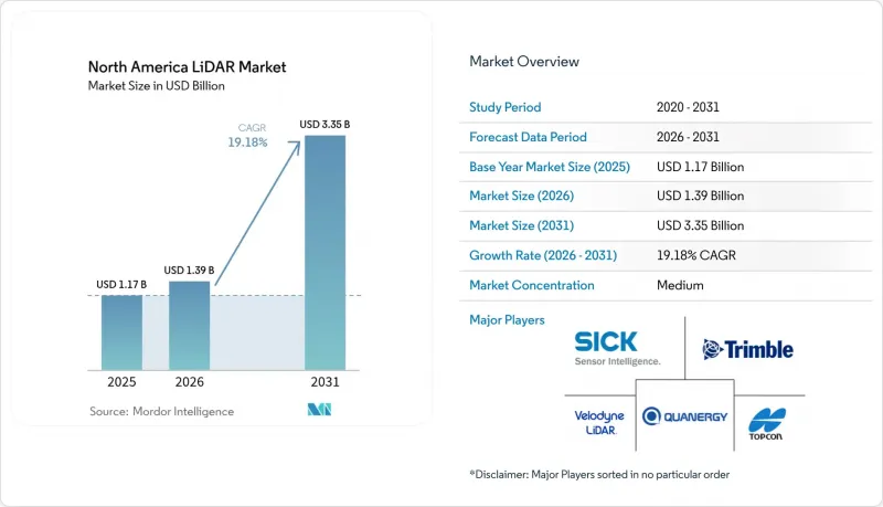
據 Mordor Intelligence 稱,北美LiDAR市場預計到 2026 年價值 13.9 億美元,高於 2025 年的 11.7 億美元,預計到 2031 年將達到 33.5 億美元。
預計從 2026 年到 2031 年,其複合年成長率將達到 19.18%。
本報告按產品(機載LiDAR)、測量範圍、組件(雷射掃描儀、GPS/GNSS接收器、其他)、應用(走廊測繪/勘測、ADAS/自動駕駛車輛、其他)、最終用戶(汽車、工程/地區建築公司、其他)和地區建築公司、其他)和建設公司、其他)和地區建築公司。市場預測以美元計價。
北美LiDAR市場趨勢與洞察
透過整合固態雷射雷達加速汽車生產專案。
固態感測器正從有限的先導計畫走向主流量產。 VolvoEX90車型大量採用Luminar感測器,凸顯了OEM廠商對其高可靠性和低機械複雜性的信心。 BMWi7和福斯ID.Buzz均採用Innoviz的感測器實現L3級自動駕駛功能,而豐田則實現了晶片級成本的降低,使其得以在中端市場應用。合賽在全球汽車市場37%的佔有率清晰地表明,規模經濟正在加速價格競爭。隨著單位經濟效益的提升,北美雷射雷達市場正見證著電動皮卡中感測器應用的增加,以滿足美國聯邦公路交通安全管理局(FMCSA)針對重型車輛的自動緊急煞車法規。
透過超視距無人機作業變革基礎設施監測
加拿大運輸部2025年無人機系統(RPAS)法規授權使用中型無人機進行超視距(BVLOS)作業,從而能夠在偏遠省份以經濟高效的方式進行雷射雷達(LiDAR)走廊測繪。美國聯邦航空管理局(FAA)的第107部分豁免也反映了類似的柔軟性,並加快了對公共產業和鐵路的巡檢。美國國家海洋暨大氣總署(NOAA)的高空超視距宣傳活動顯示了無人機作業的成熟度,而私人業者正在為電動垂直起降(eVTOL)飛機配備輕型掃描儀,以便在一次飛行中勘測數千公里。所獲得的數據降低了人工巡檢的成本,並推動了基於雲端的數位孿生技術在資產管理中的應用。
成本競爭力挑戰導致市場滲透普遍受限
LiDAR單元的成本仍然是雷達替代方案的三到五倍,這使得它們難以被應用於售價低於3萬美元的車輛。儘管Luminar的「Halo」藍圖旨在將價格降低50%,但在2028年之前達到主流價格水平仍然充滿挑戰。像合賽這樣的中國供應商正憑藉更低的人事費用和垂直整合的光學技術加劇價格競爭。北美工廠正透過自動化來應對,但折舊免稅額機制抑制了北美LiDAR市場價格的快速波動。
細分市場分析
預計到2025年,北美LiDAR市場中,地面安裝式系統將佔總銷售額的41.30%。對高精度建築測量的需求是推動銷售的主要動力,但該細分市場的成長率仍維持在較低的兩位數水準。建築公司高度重視三腳架式設備,因為它們能夠在公路拓寬和橋樑維修專案中提供可重複的參考點。然而,ClearSkies Geomatics的租賃模式降低了購買門檻,增加了設備的部署數量,同時也給製造商的利潤率帶來了壓力。
隨著政府機構推動線性資產數位化,行動和無人機平台正以24.2%的複合年成長率成長。配備RIEGL系統的垂直起降無人機巡檢電力線的速度比地面團隊快10倍,有助於公共產業應對野火造成的責任風險。 Phase One的整合式攝影機和雷射吊艙可將飛行時間縮短40%,進而提高投資報酬率。隨著測繪公司採用功能強大的慣性測量單元(IMU)進行數據穩定,飛機運營商獲得了多年巡檢契約,從而帶動了感測器訂單的持續成長。這項轉變將擴大高移動性供應商的市場佔有率,並提升北美LiDAR市場的業務收益。
機械式LiDAR架構憑藉其成熟的測量範圍和完善的供應鏈,預計到2025年仍將佔據北美雷射雷達市場62.10%的佔有率。旋轉鏡系統廣泛應用於公路測繪車和航空測深,在這些應用中,360度全方位覆蓋比耐用性更為重要。然而,其維護週期較長且組裝複雜,導致生命週期成本較高。
由於晶圓級光學技術減少了活動部件,固態雷射雷達的複合年成長率 (CAGR) 達到了 21.2%。京瓷的 Fusion Sensor 將攝影機和雷射雷達層整合在一起,實現了無視差感知,因此對尋求更薄機殼的原始設備製造商 (OEM) 極具吸引力。海克斯康的單光子模組每秒可處理 1,400 萬個點,使中高度飛機能夠進行高速走廊掃描。隨著產量的增加,預計到 2028 年,其單位成本將與機械產品相當,供應商採用晶片整合設計的比例預計將在北美雷射雷達市場擴大。
其他福利
- Excel格式的市場預測(ME)表
- 3個月的分析師支持
目錄
第1章:引言
- 研究假設和市場定義
- 調查範圍
第2章:調查方法
第3章執行摘要
第4章 市場狀況
- 市場概覽
- 市場促進因素
- 美國汽車製造商在L3級自動駕駛汽車專案中快速部署固態雷射雷達
- 美國聯邦航空管理局的超視距飛行豁免加速了加拿大對商業無人機飛行航道測繪的需求。
- 美國老舊交通基礎設施的數位孿生計畫投資激增。
- 利用LiDAR技術的智慧走廊項目,由國際亞洲研究所(美國)資助(2024-2028 年)
- 為了遵守 FMCSA 更嚴格的安全法規,電動卡車製造商正在敦促儘早採用配備 LiDAR 的 ADAS。
- 2023 年大規模野火之後,北美林業和環保組織開始轉向使用LiDAR進行野火風險建模。
- 市場限制因素
- 對大規模生產的 L2+ 車輛和雷達視覺的持續價格溢價進行比較。
- 由於缺乏雷射雷達數據處理方面的熟練人員,導致州交通運輸部 (DOT) 專案延誤。
- 高性能雷射的出口限制正在限制加拿大航太供應商。
- Velodyne和Ouster合併後,採購方面存在不確定性。
- 價值供應鏈分析
- 監理展望
- 技術展望
- 波特五力分析
- 投資分析
第5章 市場規模與成長預測
- 依產品
- 航空LiDAR
- 地面LiDAR
- 用於行動設備和無人機的雷射雷達
- 按類型
- 機械LiDAR
- 固態雷射雷達
- 按範圍
- 短距離(小於100公尺)
- 中等距離(100-300公尺)
- 長距離(超過300公尺)
- 按組件
- 雷射掃描儀
- GPS/GNSS接收器
- 慣性測量單元(IMU)
- 攝影機和其他感測器
- 透過使用
- 走廊測繪
- 高級駕駛輔助系統和自動駕駛汽車
- 工程與施工
- 環境/林業
- 安全與執法機關
- 最終用戶
- 車
- 工程建設公司
- 工業和公共產業
- 航太/國防
- 聯邦和州政府機構
- 國家
- 美國
- 加拿大
- 墨西哥
第6章 競爭情勢
- 市場集中度
- 策略趨勢
- 市佔率分析
- 公司簡介
- Ouster 公司(包括 Velodyne)
- Teledyne Optech
- Trimble Inc.
- Leica Geosystems AG(Hexagon)
- Innoviz Technologies
- Sick AG
- Topcon Corporation
- LeddarTech Inc.
- Faro Technologies Inc.
- DENSO Corporation
- RoboSense(美國)
- AEye Inc.
- Luminar Technologies Inc.
- Valeo SA
- Quanergy Systems Inc.
- Hesai Technology(NA operations)
- Phoenix LiDAR Systems
- Geo-SLAM Ltd.
- RIEGL Laser Measurement Systems
- MicroVision Inc.
- Neptec Technologies Corp.
- Phantom Intelligence Inc.
- Continental AG
第7章 市場機會與未來展望
According to Mordor Intelligence, North America LiDAR market size in 2026 is estimated at USD 1.39 billion, growing from 2025 value of USD 1.17 billion with 2031 projections showing USD 3.35 billion, growing at 19.18% CAGR over 2026-2031.
This report is Segmented by Product (Aerial LiDAR, Ground-Based LiDAR), Type (Mechanical LiDAR, Solid-State LiDAR), Range, Component (Laser Scanners, GPS/GNSS Receiver and More), Application (Corridor Mapping and Surveying, ADAS and Autonomous Vehicles, and More), End-User (Automotive, Engineering and Construction Firms, and More), and Geography. The Market Forecasts are Provided in Terms of Value (USD).
North America LiDAR Market Trends and Insights
Solid-State LiDAR Integration Accelerates Automotive Production Programs
Solid-state sensors are moving from limited pilots into mainstream production programs. Luminar's series supply on Volvo's EX90 confirms OEM confidence in higher reliability and reduced mechanical complexity. BMW's i7 and Volkswagen's ID.Buzz integrate Innoviz units for Level 3 capability, while Toyota reports chip-level cost reductions that open mid-segment adoption. Hesai's 37% global automotive share underscores how scale economics force price competition. As unit economics improve, the North America LiDAR market embeds sensors in electric pickups to satisfy forthcoming FMCSA automatic emergency braking rules for heavy vehicles.
BVLOS Drone Operations Transform Infrastructure Monitoring
Transport Canada's 2025 RPAS regulations authorize medium-sized drones for beyond-visual-line-of-sight operations, enabling cost-effective LiDAR corridor mapping in remote provinces. FAA Part 107 waivers mirror this flexibility south of the border, accelerating utility and rail inspections. NOAA's high-altitude BVLOS campaigns demonstrate operational maturity, while commercial operators deploy lightweight scanners on eVTOL craft to survey thousands of kilometres per flight. Resulting data reduces manual inspection costs and fuels cloud-based digital twins for asset managers.
Cost Competitiveness Challenges Limit Mass-Market Penetration
LiDAR units still cost three to five times more than radar alternatives, deterring inclusion in sub-USD 30,000 vehicles. Luminar's Halo roadmap targets a 50% price cut, yet mainstream parity remains elusive before 2028. Chinese suppliers such as Hesai pressure margins through lower labour costs and vertically integrated optics. North American factories respond with automation, but depreciation schedules constrain rapid price movements in the North America LiDAR market.
Other drivers and restraints analyzed in the detailed report include:
- Digital Twin Infrastructure Projects Drive Long-Term Demand
- Smart-Corridor Initiatives Leverage Federal Infrastructure Funding
- Workforce Development Gaps Constrain Project Execution
For complete list of drivers and restraints, kindly check the Table Of Contents.
Segment Analysis
Ground-based systems held 41.30% of 2025 revenue in the North America LiDAR market. Continued demand for high-accuracy construction staking anchors sales, yet the segment's growth lags at low-double-digit rates. Contractors value tripod-mounted units for repeatable benchmarks during highway widening and bridge retrofits. However, rental models from ClearSkies Geomatics reduce ownership barriers, trimming manufacturer margins but enlarging the installed base.
Mobile and UAV platforms grow at 24.2% CAGR as agencies digitize linear assets. RIEGL-based VTOL drones cover transmission lines 10 times faster than terrestrial teams, supporting utilities facing wildfire liability. Phase One's integrated camera-laser pods cut flight hours 40%, enhancing ROI. As survey firms embed robust IMUs to stabilize data, fleet operators win multi-year inspection contracts, feeding sustained sensor orders. This migration boosts share for agile suppliers and elevate service revenues across the North America LiDAR market.
Mechanical architectures still command 62.10% share of the North America LiDAR market size in 2025 thanks to proven range and established supply chains. Rotating mirror designs service highway mapping vans and airborne bathymetric surveys where 360-degree coverage outweighs durability concerns. Yet maintenance intervals and assembly complexity inflate lifecycle costs.
Solid-state variants post 21.2% CAGR as wafer-level optics deliver fewer moving parts. Kyocera's fusion sensor merges camera and LiDAR layers for parallax-free perception, attractive to OEMs demanding slimmer housings. Hexagon's single-photon module pushes 14 million points per second, enabling fast corridor scans from mid-altitude aircraft. As volume scales, per-unit cost is projected to reach parity with mechanical peers by 2028, shifting design wins toward chip-integrated suppliers within the North America LiDAR market.
Complete Report Scope:
- By Product
- Aerial LiDAR
- Ground-based LiDAR
- Mobile and UAV LiDAR
- By Type
- Mechanical LiDAR
- Solid-state LiDAR
- By Range
- Short-range (<100 m)
- Medium-range (100-300 m)
- Long-range (>300 m)
- By Component
- Laser Scanners
- GPS/GNSS Receiver
- Inertial Measurement Unit (IMU)
- Camera and Other Sensors
- By Application
- Corridor Mapping and Surveying
- ADAS and Autonomous Vehicles
- Engineering and Construction
- Environmental and Forestry
- Security and Law Enforcement
- By End-User
- Automotive
- Engineering and Construction Firms
- Industrial and Utilities
- Aerospace and Defense
- Federal and State Government Agencies
- By Country
- United States
- Canada
- Mexico
List of Companies Covered in this Report:
- Ouster Inc. (incl. Velodyne)
- Teledyne Optech
- Trimble Inc.
- Leica Geosystems AG (Hexagon)
- Innoviz Technologies
- Sick AG
- Topcon Corporation
- LeddarTech Inc.
- Faro Technologies Inc.
- DENSO Corporation
- RoboSense (USA)
- AEye Inc.
- Luminar Technologies Inc.
- Valeo SA
- Quanergy Systems Inc.
- Hesai Technology (NA operations)
- Phoenix LiDAR Systems
- Geo-SLAM Ltd.
- RIEGL Laser Measurement Systems
- MicroVision Inc.
- Neptec Technologies Corp.
- Phantom Intelligence Inc.
- Continental AG
Additional Benefits:
- The market estimate (ME) sheet in Excel format
- 3 months of analyst support
TABLE OF CONTENTS
1 INTRODUCTION
- 1.1 Study Assumptions and Market Definition
- 1.2 Scope of the Study
2 RESEARCH METHODOLOGY
3 EXECUTIVE SUMMARY
4 MARKET LANDSCAPE
- 4.1 Market Overview
- 4.2 Market Drivers
- 4.2.1 Rapid integration of solid-state LiDAR in Level-3 autonomous vehicle programs by U.S. OEMs
- 4.2.2 FAA BVLOS waivers accelerating commercial drone corridor mapping demand in Canada
- 4.2.3 Surging investments in digital-twin projects for aging U.S. transportation infrastructure
- 4.2.4 LiDAR-enriched Smart-Corridor initiatives under U.S. IIJA funding (2024-2028)
- 4.2.5 Early-mover adoption of LiDAR-embedded ADAS by electric-truck makers to meet stricter FMCSA safety mandates
- 4.2.6 North-American forestry and environmental agencies pivoting to LiDAR for wildfire-risk modelling post-2023 mega-fires
- 4.3 Market Restraints
- 4.3.1 Persistent price-premium vs. radar/vision in mass-produced L2+ vehicles
- 4.3.2 Skilled-talent scarcity in LiDAR data processing delaying state-DOT projects
- 4.3.3 Export-control restrictions on high-performance lasers limiting Canadian aerospace suppliers
- 4.3.4 Post-merger procurement uncertainty after Velodyne-Ouster consolidation
- 4.4 Value / Supply-Chain Analysis
- 4.5 Regulatory Outlook
- 4.6 Technological Outlook
- 4.7 Porter's Five Forces Analysis
- 4.7.1 Bargaining Power of Buyers/Consumers
- 4.7.2 Bargaining Power of Suppliers
- 4.7.3 Threat of New Entrants
- 4.7.4 Threat of Substitute Products
- 4.7.5 Intensity of Competitive Rivalry
- 4.8 Investment Analysis
5 MARKET SIZE AND GROWTH FORECASTS (VALUE)
- 5.1 By Product
- 5.1.1 Aerial LiDAR
- 5.1.2 Ground-based LiDAR
- 5.1.3 Mobile and UAV LiDAR
- 5.2 By Type
- 5.2.1 Mechanical LiDAR
- 5.2.2 Solid-state LiDAR
- 5.3 By Range
- 5.3.1 Short-range (<100 m)
- 5.3.2 Medium-range (100-300 m)
- 5.3.3 Long-range (>300 m)
- 5.4 By Component
- 5.4.1 Laser Scanners
- 5.4.2 GPS/GNSS Receiver
- 5.4.3 Inertial Measurement Unit (IMU)
- 5.4.4 Camera and Other Sensors
- 5.5 By Application
- 5.5.1 Corridor Mapping and Surveying
- 5.5.2 ADAS and Autonomous Vehicles
- 5.5.3 Engineering and Construction
- 5.5.4 Environmental and Forestry
- 5.5.5 Security and Law Enforcement
- 5.6 By End-User
- 5.6.1 Automotive
- 5.6.2 Engineering and Construction Firms
- 5.6.3 Industrial and Utilities
- 5.6.4 Aerospace and Defense
- 5.6.5 Federal and State Government Agencies
- 5.7 By Country
- 5.7.1 United States
- 5.7.2 Canada
- 5.7.3 Mexico
6 COMPETITIVE LANDSCAPE
- 6.1 Market Concentration
- 6.2 Strategic Moves
- 6.3 Market Share Analysis
- 6.4 Company Profiles (includes Global-level Overview, Market-level Overview, Core Segments, Financials, Strategic Info, Market Rank/Share, Products and Services, Recent Developments)
- 6.4.1 Ouster Inc. (incl. Velodyne)
- 6.4.2 Teledyne Optech
- 6.4.3 Trimble Inc.
- 6.4.4 Leica Geosystems AG (Hexagon)
- 6.4.5 Innoviz Technologies
- 6.4.6 Sick AG
- 6.4.7 Topcon Corporation
- 6.4.8 LeddarTech Inc.
- 6.4.9 Faro Technologies Inc.
- 6.4.10 DENSO Corporation
- 6.4.11 RoboSense (USA)
- 6.4.12 AEye Inc.
- 6.4.13 Luminar Technologies Inc.
- 6.4.14 Valeo SA
- 6.4.15 Quanergy Systems Inc.
- 6.4.16 Hesai Technology (NA operations)
- 6.4.17 Phoenix LiDAR Systems
- 6.4.18 Geo-SLAM Ltd.
- 6.4.19 RIEGL Laser Measurement Systems
- 6.4.20 MicroVision Inc.
- 6.4.21 Neptec Technologies Corp.
- 6.4.22 Phantom Intelligence Inc.
- 6.4.23 Continental AG
7 MARKET OPPORTUNITIES AND FUTURE OUTLOOK
- 7.1 White-space and Unmet-need Assessment

 中東和非洲雷射雷達市場:市場佔有率分析、行業趨勢和統計數據以及成長預測(2026-2031 年)
 風力發電雷射雷達市場:按類型、安裝配置、測量範圍、應用、最終用戶、國家及地區分類-全球產業分析、市場規模、市場佔有率及2026年至2033年預測歐洲雷射雷達:市場佔有率分析、產業趨勢與統計及成長預測(2026-2031 年)
 LiDAR市場-2026-2032年全球市場預測
 LiDAR半導體市場預測至2034年-全球分析(按半導體類型、波長、LiDAR類型、技術、組件整合、最終用戶和地區分類)
 LiDAR市場機會、成長促進因素、產業趨勢分析及2026-2035年預測。
 風力發電雷射雷達系統市場規模、佔有率及成長分析:依系統結構設定、測量方法、主要商業應用、終端用戶產業、通路及地區分類-2026-2033年產業預測
 風力發電雷射雷達市場-全球產業規模、佔有率、趨勢、機會、預測:依部署方式、應用、技術、範圍、地區和競爭格局分類,2021-2031年光學檢測與測距市場預測至2034年-全球按類型、組件、測量距離、安裝、服務、技術、應用和地區分類的分析
 LiDAR測繪市場分析及預測(至2035年):按類型、產品、服務、技術、組件、應用、部署、最終用戶和功能分類