


 |
市場調查報告書
商品編碼
2121918
中東和非洲地區市場分析:市場佔有率分析、行業趨勢和統計數據、成長預測(2026-2031年)MEA Location Analytics - Market Share Analysis, Industry Trends & Statistics, Growth Forecasts (2026 - 2031) |
||||||

※ 本網頁內容可能與最新版本有所差異。詳細情況請與我們聯繫。
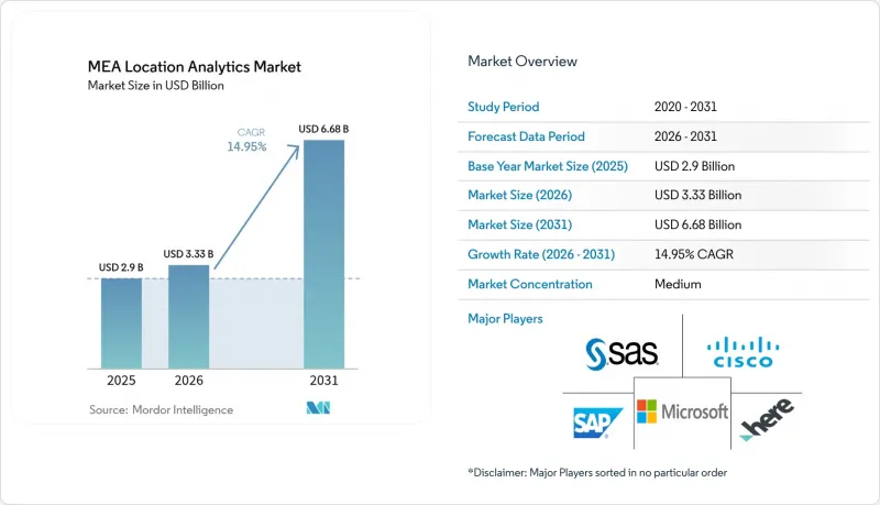
據 Mordor Intelligence 稱,中東和非洲地區的位置分析市場預計到 2026 年價值 33.3 億美元,高於 2025 年的 29 億美元,預計到 2031 年將達到 66.8 億美元。
預計從 2026 年到 2031 年,其複合年成長率將達到 14.95%。
本報告按地點(室外、室內)、部署模式(本地部署、按需(雲端))、應用程式(遠端監控、資產管理、設施管理)、元件(軟體和服務)、產業(零售、製造等)和國家/地區進行細分。市場預測以價值(美元)表示。
中東和非洲地區位置分析市場的趨勢和洞察。
海灣合作理事會智慧城市計畫中物聯網感測器的普及。
利雅德、杜拜和杜哈遍布的感測器網路持續產生帶有地理標記的資料流,這需要一個強大的分析平台,能夠即時擷取和視覺化資料。杜拜已部署超過200項智慧服務,而麥加正在部署支援LoRa的設備,以確保朝覲期間山區網路連接的暢通。市政機構正在利用這些數據流來預測交通流量、最佳化垃圾收集並監控公共安全事件。由此產生的大量數據迫使城市管理部門部署邊緣處理和人工智慧演算法,以便在資訊來源過濾和分析數據,從而加快決策速度。隨著試點部署逐步投入全面運營,市政競標要求中越來越明確規定了開放API和多重通訊協定支持,這促進了供應商生態系統的發展。
5G小型基地台部署的加速使得即時分析成為可能。
海灣合作理事會(GCC)各國首都的5G網路廣泛涵蓋,實現了亞毫秒延遲,從而支持自動駕駛班車、無人機巡檢和擴增實境(AR)導航等先進應用。電信營運商正與市政負責人合作,將小型基地台整合到街道基礎設施中,以提高訊號密度,並實現高解析度追蹤和影像分析。新增頻寬將高清3D地圖即時傳輸到控制室,從而加強緊急應變協調。石油、公共產業和物流等行業的公司正在調整網路升級和分析藍圖,以確保行動資產的資料流不間斷。早期採用者報告稱,透過預測性維護,邊緣人工智慧在本地處理感測器警報,從而降低了營運成本。
資料主權和隱私法規
沙烏地阿拉伯的《個人資料保護法》和阿拉伯聯合大公國的《聯邦資料保護法規》要求資料處理者將高度敏感的位置資料儲存在其境內。醫療保健、金融和國防項目受到嚴格的同意和審計追蹤要求的約束,這導致本地部署或主權雲端解決方案的部署量增加。跨國供應商正推出本地雲端區域並提供多層資料本地化來應對這項挑戰,從而隔離個人識別資訊。合規性檢查會增加專案工期和成本,通常需要進行法律審查、加密金鑰管理和本地事件回應協定。
細分市場分析
2025年,隨著運輸部和公共工程部大力推動公路、港口和地鐵系統的數位化,戶外解決方案在中東和非洲地區的位置分析市場中佔據了71.35%的佔有率。將攝影機拍攝的影像與地理圍欄演算法相結合,實現了動態收費和最佳化交通號誌控制,從而緩解了主要幹道的交通堵塞。預計到2031年,在覆蓋全城的交通行動服務(MaaS)平台普及的推動下,中東和非洲地區戶外位置分析市場的規模將穩定成長。在室內,購物中心、機場和醫院正在部署信標和LiDAR(LiDAR)來深入了解顧客行為和資產使用情況。領先的購物中心在部署方面最為先進,因為營運效益遠遠超出硬體和校準成本。近距離追蹤技術彌合了商店應用程式和忠誠度計畫之間的差距,提高了宣傳活動的轉換率。
在新的應用場景中,室內外資料集正在融合,以便在不中斷訊號的情況下追蹤供應鏈各環節的資產。物流業者透過在單一平台上繪製交叉轉運倉庫和最後一公里路線圖,提高了交接準確率並減少了貨物遺失。設施管理人員正在整合建築資訊模型 (BIM) 和地理資訊系統 (GIS) 控制面板,以空間上下文可視化維護工單。這種整合催生了新的供應商,他們提供整合解決方案,結合數位化樓層平面圖、Wi-Fi 熱力學圖和全球導航衛星系統 (GNSS) 校正服務,預計這些解決方案將在中東和非洲 (MEA) 地區的位置分析行業實現兩位數成長。
預計到2025年,雲端平台將佔據中東和非洲地區(MEA)位置分析市場65.40%的佔有率,並以19.18%的複合年成長率持續超越本地部署系統。電信營運商、零售商和公共部門機構正在利用超大規模資料中心業者資料中心靈活地儲存和處理TB級Terabyte記錄。隨著更多地區遵守資料主權原則,預計2027年,MEA地區雲端託管工作負載的位置分析市場規模將超過本地部署支出。區域特定的安全認證和低延遲邊緣區域正在加速對延遲敏感的應用(例如自動接駁車控制和即時人群監控)遷移到雲端。
對於與公共網路隔離的敏感專案和設施而言,本地部署解決方案仍然至關重要。國防機構和關鍵基礎設施營運商正在部署環境適應性伺服器和私有雲端,以滿足嚴格的效能和保密性要求。混合架構正變得越來越普遍,它會整合邊緣設備以在本地處理流數據,並將聚合的分析結果卸載到主權雲以進行長期分析。供應商正透過預先建置連接器、零信任框架和按需付費使用制模式來緩解預算限制,從而實現差異化競爭,這表明部署柔軟性是 MEA(大都會區)位置分析行業採購決策的關鍵因素。
其他好處:
- Excel格式的市場預測(ME)表
- 3個月的分析師支持
目錄
第1章:引言
- 研究假設和市場定義
- 調查範圍
第2章:調查方法
第3章執行摘要
第4章 市場狀況
- 市場概覽
- 市場促進因素
- 海灣合作理事會智慧城市計畫中物聯網感測器的普及
- 5G小型基地台的加速部署將實現即時分析。
- 零售業和政府機構採用雲端優先的GIS/BI技術
- 大型能源專案ESG(環境、社會和治理)方面的強制性地域性報告
- 市場限制因素
- 關於資料主權和隱私的法規
- 室內定位技術投入高,但缺乏相關技能。
- 價值供應鏈分析
- 監理情勢
- 技術展望
- 波特五力模型
- 投資分析
第5章 市場規模與成長預測
- 按位置
- 戶外的
- 室內的
- 按部署模式
- 現場
- 按需(雲端)
- 透過使用
- 遠端監控
- 資產管理
- 設施管理
- 按行業
- 零售
- 製造業
- 衛生保健
- 政府
- 能源與電力
- 其他行業
- 按組件
- 軟體
- 服務
- 國家
- 阿拉伯聯合大公國
- 沙烏地阿拉伯
- 以色列
第6章 競爭情勢
- 市場集中度
- 策略趨勢
- 市佔率分析
- 公司簡介
- Cisco Systems
- Microsoft Corporation
- HERE Technologies
- SAS Institute Inc.
- Oracle Corporation
- SAP SE
- Esri
- Tibco Software Inc.
- Pitney Bowes
- Galigeo
- Hexagon AB
- TomTom
- Trimble Inc.
- Mapbox
- Alteryx
- CARTO
- Foursquare
- Splunk Inc.
- Ubisense
第7章 市場機會與未來展望
According to Mordor Intelligence, the MEA location analytics market size in 2026 is estimated at USD 3.33 billion, growing from 2025 value of USD 2.9 billion with 2031 projections showing USD 6.68 billion, growing at 14.95% CAGR over 2026-2031.
This report is Segmented by Location (Outdoor, Indoor), Deployment Model (On-Premise, On-Demand (Cloud)), Application (Remote Monitoring, Asset Management, and Facility Management), Component (Software and Services), Vertical (Retail, Manufacturing, and More), and by Country. The Market Forecasts are Provided in Terms of Value (USD).
MEA Location Analytics Market Trends and Insights
Proliferation of IoT Sensors in GCC Smart-City Programmes
Ubiquitous sensor networks in Riyadh, Dubai, and Doha generate continuous geotagged streams that demand powerful analytics platforms capable of real-time ingestion and visualization. Dubai has implemented more than 200 smart services, while Makkah is integrating LoRa-enabled devices to maintain connectivity in mountainous terrain during the Hajj season. Municipal agencies use these data flows to predict traffic density, optimize waste collection, and monitor public safety incidents. The resulting data volume pushes city authorities to adopt edge processing and AI algorithms that filter and analyze information at the source, accelerating decision-making. As pilot deployments shift to full production, municipal tenders increasingly specify open APIs and multi-protocol compatibility, encouraging a broader supplier ecosystem.
Accelerated 5G Small-Cell Rollout Enabling Real-Time Analytics
Widespread 5G coverage in GCC capitals delivers sub-10-millisecond latency, allowing advanced applications such as autonomous shuttles, drone-based inspection, and augmented-reality wayfinding. Operators collaborate with municipal planners to embed small cells in street furniture, which improves signal density for high-resolution tracking and video analytics. The new bandwidth permits live streaming of high-definition 3D maps to control rooms, enhancing emergency response coordination. Enterprises across oil, utilities, and logistics verticals are aligning network upgrades with analytics roadmaps, citing the need for uninterrupted data flows from mobile assets. Early adopters report operational cost savings from predictive maintenance once edge AI processes sensor alerts locally.
Data-Sovereignty and Privacy Regulations
Saudi Arabia's Personal Data Protection Law and the UAE's Federal Decree-Law on Data Protection oblige processors to store sensitive location attributes within national borders. Healthcare, finance, and defense projects face strict consent and audit trails, prompting on-premises or sovereign cloud deployments. Multinational vendors respond by launching local cloud regions and offering data-localization tiers that segregate personally identifiable information. Compliance checks elevate project timelines and costs, often requiring legal reviews, encryption key management, and local incident-response protocols.
Other drivers and restraints analyzed in the detailed report include:
- Cloud-First GIS/BI Adoption Across Retail and Government
- Mandatory ESG Geo-Reporting for Large Energy Projects
- High CAPEX and Skills Gap for Indoor Positioning
For complete list of drivers and restraints, kindly check the Table Of Contents.
Segment Analysis
Outdoor solutions represented 71.35% of the MEA location analytics market in 2025 as ministries of transport and public works digitized highways, ports, and metro systems. Camera feeds combined with geofencing algorithms support dynamic tolling and traffic-signal optimization, cutting congestion on flagship corridors. The MEA location analytics market size for outdoor deployments is forecast to climb steadily through 2031, benefiting from city-wide mobility-as-a-service platforms. Indoors, malls, airports, and hospitals deploy beacons and LiDAR to gain customer-journey and asset-utilization insights. Uptake is strongest in tier-one malls where operational gains offset hardware and calibration costs. Near-field tracking bridges the gap between store apps and loyalty programs, enhancing campaign conversion.
Emerging use cases blend indoor and outdoor datasets to track assets across supply-chain nodes without signal drop. Logistics operators map cross-dock warehouses and final-mile routes on a single platform, improving hand-off accuracy and reducing misplacement incidents. Facility managers integrate building information modeling with GIS dashboards to visualize maintenance tickets in spatial context. This convergence draws new vendors that bundle floor-plan digitization, Wi-Fi heat-mapping, and global navigation satellite system (GNSS) correction services into unified offerings, positioning them for double-digit gains within the broader MEA location analytics industry.
Cloud platforms owned 65.40% of the MEA location analytics market in 2025 and continue to outpace on-premises systems with a 19.18% CAGR. Telecom operators, retailers, and public agencies rely on regional data centers operated by hyperscalers to elastically store and process terabytes of geospatial records. The MEA location analytics market size for cloud-hosted workloads is projected to surpass on-premises spending before 2027 as data-sovereignty-compliant regions multiply. Region-specific security certifications and low-latency edge zones encourage migration of latency-sensitive applications such as autonomous shuttle control and real-time crowd monitoring.
On-premises solutions remain essential for classified projects and installations disconnected from public networks. Defense and critical-infrastructure operators deploy ruggedized servers and private clouds to meet stringent performance and confidentiality targets. Hybrid architectures gain traction, integrating edge appliances that process streaming data locally before offloading aggregated insights to sovereign clouds for long-term analytics. Vendors differentiate through pre-built connectors, zero-trust frameworks, and pay-as-you-go pricing to ease budget constraints, illustrating how deployment flexibility underpins purchasing decisions across the MEA location analytics industry.
Complete Report Scope:
- By Location
- Outdoor
- Indoor
- By Deployment Model
- On-premise
- On-demand (Cloud)
- By Application
- Remote Monitoring
- Asset Management
- Facility Management
- By Vertical
- Retail
- Manufacturing
- Healthcare
- Government
- Energy and Power
- Other Verticals
- By Component
- Software
- Services
- By Country
- United Arab Emirates
- Saudi Arabia
- Israel
List of Companies Covered in this Report:
- Cisco Systems
- Microsoft Corporation
- HERE Technologies
- SAS Institute Inc.
- Oracle Corporation
- SAP SE
- Esri
- Tibco Software Inc.
- Pitney Bowes
- Galigeo
- Hexagon AB
- TomTom
- Trimble Inc.
- Mapbox
- Alteryx
- CARTO
- Foursquare
- Splunk Inc.
- Ubisense
Additional Benefits:
- The market estimate (ME) sheet in Excel format
- 3 months of analyst support
TABLE OF CONTENTS
1 INTRODUCTION
- 1.1 Study Assumptions and Market Definition
- 1.2 Scope of the Study
2 RESEARCH METHODOLOGY
3 EXECUTIVE SUMMARY
4 MARKET LANDSCAPE
- 4.1 Market Overview
- 4.2 Market Drivers
- 4.2.1 Proliferation of IoT sensors in GCC smart-city programmes
- 4.2.2 Accelerated 5G small-cell rollout enabling real-time analytics
- 4.2.3 Cloud-first GIS/BI adoption across retail and government
- 4.2.4 Mandatory ESG geo-reporting for large energy projects
- 4.3 Market Restraints
- 4.3.1 Data-sovereignty and privacy regulations
- 4.3.2 High CAPEX and skills gap for indoor positioning
- 4.4 Value / Supply-Chain Analysis
- 4.5 Regulatory Landscape
- 4.6 Technological Outlook
- 4.7 Porters Five Forces
- 4.7.1 Bargaining Power of Suppliers
- 4.7.2 Bargaining Power of Buyers
- 4.7.3 Threat of New Entrants
- 4.7.4 Intensity of Competitive Rivalry
- 4.7.5 Threat of Substitutes
- 4.8 Investment Analysis
5 MARKET SIZE AND GROWTH FORECASTS (VALUE)
- 5.1 By Location
- 5.1.1 Outdoor
- 5.1.2 Indoor
- 5.2 By Deployment Model
- 5.2.1 On-premise
- 5.2.2 On-demand (Cloud)
- 5.3 By Application
- 5.3.1 Remote Monitoring
- 5.3.2 Asset Management
- 5.3.3 Facility Management
- 5.4 By Vertical
- 5.4.1 Retail
- 5.4.2 Manufacturing
- 5.4.3 Healthcare
- 5.4.4 Government
- 5.4.5 Energy and Power
- 5.4.6 Other Verticals
- 5.5 By Component
- 5.5.1 Software
- 5.5.2 Services
- 5.6 By Country
- 5.6.1 United Arab Emirates
- 5.6.2 Saudi Arabia
- 5.6.3 Israel
6 COMPETITIVE LANDSCAPE
- 6.1 Market Concentration
- 6.2 Strategic Moves
- 6.3 Market Share Analysis
- 6.4 Company Profiles (includes Global level Overview, Market level overview, Core Segments, Financials as available, Strategic Information, Market Rank/Share for key companies, Products and Services, and Recent Developments)
- 6.4.1 Cisco Systems
- 6.4.2 Microsoft Corporation
- 6.4.3 HERE Technologies
- 6.4.4 SAS Institute Inc.
- 6.4.5 Oracle Corporation
- 6.4.6 SAP SE
- 6.4.7 Esri
- 6.4.8 Tibco Software Inc.
- 6.4.9 Pitney Bowes
- 6.4.10 Galigeo
- 6.4.11 Hexagon AB
- 6.4.12 TomTom
- 6.4.13 Trimble Inc.
- 6.4.14 Mapbox
- 6.4.15 Alteryx
- 6.4.16 CARTO
- 6.4.17 Foursquare
- 6.4.18 Splunk Inc.
- 6.4.19 Ubisense
7 MARKET OPPORTUNITIES AND FUTURE OUTLOOK
- 7.1 White-space and Unmet-Need Assessment

 位置分析市場規模、佔有率和趨勢分析報告:按組件、分析類型、技術、位置類型、部署方式、企業規模、最終用途和細分市場預測(2026-2033 年)
 歐洲位置分析:市場佔有率分析、行業趨勢和統計數據、成長預測(2026-2031 年)北美地區市場分析:市場佔有率分析、產業趨勢與統計、成長預測(2026-2031 年)
 位置分析市場:按組件、部署模式、分析類型和應用分類-2026-2032年全球市場預測
 位置分析市場:按元件、位置類型、部署方式、產業和地區分類
 2026年全球位置分析市場報告
 位置分析市場規模、佔有率、趨勢和預測:按組件、部署類型、位置類型、應用、最終用戶行業和地區分類,2026-2034 年
 位置分析市場分析及預測(至 2035 年):按類型、產品類型、服務、技術、組件、應用、部署類型、最終用戶和解決方案分類
 位置分析市場規模、佔有率、成長率和全球產業分析:按類型、應用和地區分類的洞察,2026-2034 年預測
 全球位置分析市場(至 2035 年):按組件類型、位置類型、部署類型、應用類型、行業類型、地區、行業趨勢和預測