


 |
市場調查報告書
商品編碼
2163592
多波長雷射雷達系統:市場佔有率分析、行業趨勢和統計數據、成長預測(2026-2031 年)Multispectral LiDAR Systems - Market Share Analysis, Industry Trends & Statistics, Growth Forecasts (2026 - 2031) |
||||||

※ 本網頁內容可能與最新版本有所差異。詳細情況請與我們聯繫。
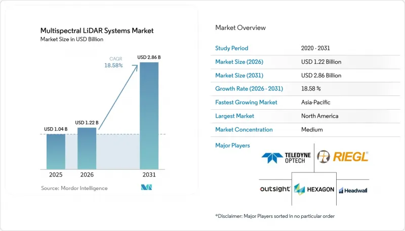
根據 Mordor Intelligence 預測,頻譜雷射雷達系統的市場規模預計將從 2025 年的 10.4 億美元成長到 2026 年的 12.2 億美元,到 2031 年達到 28.6 億美元,2026 年至 2031 年的年複合成長率(CAGR)為 18.58%。
全球頻譜雷射雷達系統市場趨勢與洞察
對同時獲取3D結構和頻譜分類的需求
被動成像和單波長雷射雷達難以區分形狀相似但材質不同的物體。例如,瀝青、濕土和草地可能具有相似的幾何形狀,但在近紅外線(NIR) 和短波紅外線(SWIR) 波段的反射率卻有所不同。頻譜系統可以在同一次掃描中捕捉這些結構和頻譜訊號。 2025 年的一項研究表明,與單波長基準相比,使用對齊的頻譜點雲可以提高城市景觀的分類精度。這種能力使得在下游機器人和分類工作流程中應用材質標籤成為可能。當分類需求與空間測量同樣重要時,頻譜雷射雷達系統市場將受益匪淺,尤其是在操作人員需要透過單一、協調的採集過程獲得結果時。
沿海、內陸水域以及地形和深度測量的成長
國家測繪計畫為地形和水文測繪系統提供了穩定的需求來源。這些項目通常採用多年採購週期,從而減少了對短期商業測繪預算的依賴。 2025年2月,泰萊地理空間公司(Teledyne Geospatial)發布了「Fathom」系統,該系統配備200萬點地形測量通道、綠色波長水文通道以及1.2億像素的RGB和近紅外線(NIR)相機。同年2月,徠卡測量系統公司(Leica Geosystems)發布了「CoastalMapper」系統,每秒可收集100萬個水文資料點和200萬個地形資料點,每小時覆蓋360平方公里。這些產品的出現使得整合式海岸測繪系統更容易作為標準產品在頻譜雷射雷達系統市場中普及。美國國家海洋暨大氣總署(NOAA)的海岸地形和水文資料專案以及美國陸軍工兵團也持續支持對綠色和近紅外線配置的需求。
高昂的採集、校準和處理成本
頻譜LiDAR系統需要獨特的光學設計、多通道檢測器以及逐波長校準。這些特性導致其購置成本高於單波長平台。專案經理可能難以將這些成本分攤到無需材料分類的任務中。此外,包含多個已註冊通道的點雲資料需要更強大的運算能力和專業的處理技能。非標準的輻射校正工作流程也會增加操作的複雜度。這些限制在南美、中東和非洲尤為突出,因為這些地區的進口關稅和校準能力限制會增加參與企業頻譜雷射雷達系統市場的公司的整體擁有成本。
細分市場分析
截至2025年,機載系統佔產品類型細分市場的48.63%。這一地位反映了其作戰範圍、有效載荷能力以及長期採購經驗。固定翼飛機和直升機非常適合海岸勘測和大規模林業專案。在這些任務中,其較長的飛行時間和攜帶多種感測器的能力是關鍵優勢。
預計2026年至2031年間,無人機搭載系統將以19.83%的複合年成長率成長。其輕量化的有效載荷能力降低了林業和礦業團隊的每公頃成本。在2026年國際地質工程展(INTERGEO 2026)上,RIEGL公司發表了「miniVUX-4UAV」無人機,平台重量不足1公斤,工作頻率高達400 kHz,精度達12毫米。地面系統目前仍主要應用於地質露頭和工業堆場,而移動系統則面向公路和港口等應用領域。頻譜LiDAR系統產業仍存在產品缺口,即學術界開發的行動原型產品與標準商業目錄產品之間存在差距,這為頻譜LiDAR系統市場帶來了商機。
到2025年,綠光和近紅外線(NIR)配置將佔頻譜雷射雷達系統市場39.47%的佔有率。 532奈米綠光和1064奈米近紅外光的組合適用於深度測量和地形強度對比測量。這種組合在海岸和植被測繪中繼續發揮核心作用。在各國的水文測量項目中,這種配置仍然是水體和地形測量的首選。
預計到2031年,近紅外線(NIR)和短波紅外線(SWIR)配置將以19.67%的複合年成長率成長。這些波長對材料的額外特異性正被應用於汽車感知技術和礦石分選領域。此外,IEC 60825-1的眼部安全要求也影響一些工業和軍事應用中較長波長的使用。綠光、近紅外線和短波紅外線三波段系統正在彌合現有雙通道產品和多波段設計之間的差距。雖然可調諧和寬頻系統目前仍主要處於原型階段,但2026年的調查顯示,對光子雷射雷達架構的研究仍在繼續。這些架構的選擇正在影響頻譜雷射雷達系統市場的產品開發。
區域分析
到2025年,北美將佔據頻譜LiDAR系統市場34.67%的佔有率。美國國家海洋暨大氣總署(NOAA)、美國陸軍工兵團和美國地質調查局(USGS)正在推動對海岸和地形測繪的需求。在加拿大,自然資源清查和森林碳計量的需求也隨之增加。墨西哥仍處於起步階段,目前主要集中在基礎建設走廊測繪方面。 Fathom和CoastalMapper於2025年2月推出,旨在滿足北美海岸測繪的需求。
預計亞太地區市場將在2026年至2031年間以19.87%的複合年成長率成長。中國的自動駕駛汽車項目以及對基於無人機的基礎設施檢測的需求正在推動該地區市場的發展。印度的「國家基礎設施管道」計畫正在滿足公路、鐵路和水路的測繪需求。在日本,土木工程產業勞動力老化使得採用無人機進行自動化測繪變得越來越重要。緊湊型無人機感測器面向那些希望以低成本進入頻譜LiDAR系統市場的商業測繪公司。
在歐洲,德國、英國和法國在2025年前已展現出顯著的市場地位,處於領先地位。芬蘭和瑞典在頻譜航空雷射雷達方面擁有豐富的營運經驗,包括與芬蘭地理空間研究所的HeliALS系統合作。 Hexagon於2026年6月收購了ITRES,將航空高光譜遙測和熱成像成像能力整合到徠卡的地理空間產品組合中。南美洲在監測亞馬遜地區和精密農業方面具有巨大潛力,但面臨關稅和校準方面的限制。同時,中東和非洲仍處於應用初期,頻譜雷射雷達系統市場的需求主要集中在國防、石油天然氣和管道測繪計畫領域。
其他好處:
- Excel格式的市場預測(ME)表
- 3個月的分析師支持
目錄
第1章:引言
- 研究假設和市場定義
- 調查範圍
第2章:調查方法
第3章執行摘要
第4章 市場狀況
- 市場概覽
- 市場促進因素
- 對同時處理3D結構和頻譜分類的需求
- 沿海、內陸水域以及地形和深度測量的成長
- 擴大精準林業和自然資源監測範圍
- 採礦、採石和生質能加工中的材料感知自動化。
- 單次飛行的數據融合減少了重飛的需要和註冊錯誤。
- AI訓練對配準頻譜和結構點雲的需求
- 市場限制因素
- 高昂的採集、校準和處理成本
- 有限的基準資料集和真實數據
- 跨頻道同步配準和作業船隊的輻射漂移
- 頻譜頻寬選擇性鎖定和工作流程碎片化
- 宏觀經濟因素對市場的影響
- 產業供應鏈分析
- 科技趨勢
- 監理情勢
- 波特五力分析
第5章 市場規模與成長預測
- 依產品類型
- 機載頻譜雷射雷達系統
- 無人機搭載頻譜雷射雷達系統
- 地面頻譜雷射雷達系統
- 移動和汽車頻譜雷射雷達系統
- 按波長組成
- 綠色 + 近紅外線(NIR)
- 綠色 + 近紅外線 + 短波紅外線 (SWIR)
- NIR+SWIR
- 多頻段和四個或更多離散波長
- 可調諧寬頻頻譜雷達
- 按平台
- 固定翼飛機
- 直升機
- 無人駕駛飛行器(UAV)
- 地面車輛和工業機械
- 三腳架、龍門架和實驗室平台
- 按最終用戶行業分類
- 政府和國防機構
- 測繪、地圖繪製和地理空間服務供應商
- 工程、建築和基礎設施(AEC)公司
- 公共產業、能源與電力公司
- 採礦和開採運營商
- 農業和林業經營者
- 環境、保護和自然資源相關組織
- 研究機構和大學
- 車
- 工業機器人
- 其他終端用戶產業
- 按地區
- 北美洲
- 美國
- 加拿大
- 墨西哥
- 南美洲
- 巴西
- 阿根廷
- 其他南美國家
- 歐洲
- 德國
- 英國
- 法國
- 義大利
- 西班牙
- 其他歐洲國家
- 亞太地區
- 中國
- 日本
- 印度
- 韓國
- 其他亞太國家
- 中東和非洲
- 中東
- 沙烏地阿拉伯
- 阿拉伯聯合大公國
- 土耳其
- 其他中東國家
- 非洲
- 南非
- 奈及利亞
- 其他非洲國家
- 中東
- 北美洲
第6章 競爭情勢
- 市場集中度
- 策略趨勢
- 市佔率分析
- 公司簡介
- Teledyne Optech Incorporated
- RIEGL Laser Measurement Systems GmbH
- Hexagon AB
- Leica Geosystems AG
- IRIDESENSE SAS
- Outsight SA
- Finnish Geospatial Research Institute
- National Land Survey of Finland
- Headwall Photonics, Inc.
- GRYFN, Inc.
- Ouster, Inc.
- Velodyne Lidar, Inc.
- SBG Systems SAS
- Applanix Corporation
- Specim, Spectral Imaging Ltd.
- Teledyne CARIS, Inc.
- Optech Incorporated
- OPEGIEKA Sp. z oo
- SensUp SAS
- Outsight Tech SAS
第7章 市場機會與未來展望
According to Mordor Intelligence, the multispectral LiDAR systems market size is projected to expand from USD 1.04 billion in 2025 to USD 1.22 billion in 2026, and to USD 2.86 billion by 2031, registering a CAGR of 18.58% between 2026 and 2031.
Global Multispectral LiDAR Systems Market Trends and Insights
Demand for Simultaneous 3D Structure and Spectral Classification
Passive imagery and single-wavelength LiDAR can struggle to distinguish objects with similar shapes but different materials. Asphalt, moist soil, and grass can have comparable geometric profiles while showing different NIR and SWIR reflectance. Multispectral systems capture these structural and spectral signals in the same pass. A 2025 study reported improved urban scene classification from co-registered multispectral point clouds when compared with single-band baselines. This capability supports the use of material labels in downstream robotics and sorting workflows. The Multispectral LiDAR Systems Market benefits when classification needs are as important as spatial measurement, particularly when operators need results from a single coordinated collection process.
Growth in Coastal, Inland-Water, and Topo-Bathymetric Mapping
National mapping programs provide a steady source of demand for topo-bathymetric systems. These programs generally use multiyear procurement cycles, which can reduce sensitivity to short-term commercial survey budgets. Teledyne Geospatial introduced Fathom in February 2025 with a 2,000,000 points/sec topographic channel, a green bathymetric channel, and a 120 MP RGB and NIR camera. Leica Geosystems introduced CoastalMapper in February 2025, capable of collecting 1 million bathymetric and 2 million topographic points/second, covering 360 km2/hr. These releases made integrated coastal mapping systems more accessible as standard products within the Multispectral LiDAR Systems Market. NOAA's coastal topobathy data program and the U.S. Army Corps of Engineers continue to support demand for green and NIR configurations.
High Acquisition, Calibration, and Processing Cost
Multispectral LiDAR systems require proprietary optical designs, multichannel detectors, and wavelength-specific calibration. These features make their acquisition cost higher than that of single-wavelength platforms. Project operators may struggle to spread this cost across assignments that do not need material classification. Processing also requires more computing capacity and specialized skills because the point clouds contain multiple registered channels. Nonstandard radiometric correction workflows can increase operating complexity. The constraint is strongest in South America and Middle East, and Africa, where import duties and limited calibration capacity can increase the total cost of ownership for participants in the Multispectral LiDAR Systems Market.
Other drivers and restraints analyzed in the detailed report include:
- Expansion of Precision Forestry and Natural-Resource Monitoring
- One-Flight Data Fusion Reducing Repeat Missions and Registration Error
- Limited Benchmark Datasets and Ground Truth
For complete list of drivers and restraints, kindly check the Table Of Contents.
Segment Analysis
Airborne systems held 48.63% of the product-type segment in 2025. Their position reflects operational range, payload capacity, and a long procurement history. Fixed-wing aircraft and helicopters remain suitable for coastal surveys and large forestry assignments. These missions benefit from endurance and the ability to carry several sensors.
UAV-mounted systems are projected to expand at a 19.83% CAGR from 2026 to 2031. Lower payload weight can reduce cost per hectare for forestry and mine-site teams. RIEGL presented the miniVUX-4UAV at INTERGEO 2026, featuring up to 400 kHz operation and 12 mm accuracy on a platform below 1 kg. Terrestrial systems remain focused on geological outcrops and industrial stockpiles, while mobile systems support highway and port applications. The Multispectral LiDAR Systems Industry continues to experience a product gap between academic mobile prototypes and standard commercial catalogs, leaving an opening in the Multispectral LiDAR Systems Market.
Green and NIR configurations accounted for 39.47% of the Multispectral LiDAR Systems Market in 2025. The 532 nm green and 1,064 nm NIR pairing supports bathymetry and topographic intensity contrast. This pairing remains central to coastal and vegetation mapping. National hydrographic programs continue to favor this configuration for water and terrain surveys.
NIR and SWIR configurations are projected to expand at a 19.67% CAGR through 2031. Automotive perception and ore sorting benefit from their additional material specificity. IEC 60825-1 eye-safety requirements also influence the use of longer wavelengths in some industrial and military applications. Green, NIR, and SWIR triband systems bridge the gap between established 2-channel products and multiband designs. Tunable and broadband systems remain largely at the prototype stage, although research in 2026 showed continued work on photonic LiDAR architectures. These architecture choices affect product development within the Multispectral LiDAR Systems Market.
Complete Report Scope:
- By Product Type
- Airborne Multispectral LiDAR Systems
- UAV-Mounted Multispectral LiDAR Systems
- Terrestrial Multispectral LiDAR Systems
- Mobile and Vehicle-Mounted Multispectral LiDAR Systems
- By Wavelength Configuration
- Green + Near-Infrared (NIR)
- Green + NIR + Short-Wave Infrared (SWIR)
- NIR + SWIR
- Multiband and Four-or-More Discrete Wavelengths
- Tunable and Broadband Spectral LiDAR
- By Platform
- Fixed-Wing Aircraft
- Helicopters
- Uncrewed Aerial Vehicles (UAVs)
- Ground Vehicles and Industrial Machines
- Tripod, Gantry, and Laboratory Platforms
- By End-User Industry
- Government and Defense Agencies
- Surveying, Mapping, and Geospatial Service Providers
- Engineering, Construction, and Infrastructure (AEC) Firms
- Utilities, Energy, and Power Operators
- Mining and Extractive Industry Operators
- Agriculture and Forestry Operators
- Environmental, Conservation, and Natural-Resource Organizations
- Research Institutions and Universities
- Automotive
- Industrial Robotics
- Other End-User Industries
- By Geography
- North America
- United States
- Canada
- Mexico
- South America
- Brazil
- Argentina
- Rest of South America
- Europe
- Germany
- United Kingdom
- France
- Italy
- Spain
- Rest of Europe
- Asia-Pacific
- China
- Japan
- India
- South Korea
- Rest of Asia-Pacific
- Middle East and Africa
- Middle East
- Saudi Arabia
- United Arab Emirates
- Turkey
- Rest of the Middle East
- Africa
- South Africa
- Nigeria
- Rest of Africa
- Middle East
- North America
Geography Analysis
North America held 34.67% of the Multispectral LiDAR Systems Market share in 2025. NOAA, the U.S. Army Corps of Engineers, and the U.S. Geological Survey support demand for coastal and topographic mapping. Canada adds demand from natural-resource inventory and forest carbon accounting. Mexico remains at an earlier stage, with activity concentrated in infrastructure corridor mapping. The February 2025 launches of Fathom and CoastalMapper were directed toward North American coastal survey requirements.
Asia-Pacific is projected to expand at a 19.87% CAGR between 2026 and 2031. China's autonomous vehicle programs and demand for drone-based infrastructure inspection support in the region. India's National Infrastructure Pipeline supports the mapping needs of highways, railways, and water bodies. Japan's aging civil engineering workforce strengthens the case for automated drone survey methods. Compact UAV sensors are positioned for commercial survey firms that need lower-cost access to the Multispectral LiDAR Systems Market.
Europe had a meaningful presence in 2025, led by Germany, the United Kingdom, and France. Finland and Sweden have extensive operational experience with multispectral airborne LiDAR, including work with the Finnish Geospatial Research Institute's HeliALS system. Hexagon acquired ITRES in June 2026, bringing airborne hyperspectral and thermal imaging capabilities into its Leica geospatial portfolio. South America offers potential in Amazon monitoring and precision agriculture but faces duties and calibration constraints, while the Middle East and Africa remain in an early adoption stage, with demand tied mainly to defense, oil and gas, and pipeline mapping projects in the Multispectral LiDAR Systems Market.
- Teledyne Optech Incorporated
- RIEGL Laser Measurement Systems GmbH
- Hexagon AB
- Leica Geosystems AG
- IRIDESENSE SAS
- Outsight SA
- Finnish Geospatial Research Institute
- National Land Survey of Finland
- Headwall Photonics, Inc.
- GRYFN, Inc.
- Ouster, Inc.
- Velodyne Lidar, Inc.
- SBG Systems SAS
- Applanix Corporation
- Specim, Spectral Imaging Ltd.
- Teledyne CARIS, Inc.
- Optech Incorporated
- OPEGIEKA Sp. z o.o.
- SensUp SAS
- Outsight Tech SAS
Additional Benefits:
- The market estimate (ME) sheet in Excel format
- 3 months of analyst support
TABLE OF CONTENTS
1 INTRODUCTION
- 1.1 Study Assumptions and Market Definition
- 1.2 Scope of the Study
2 RESEARCH METHODOLOGY
3 EXECUTIVE SUMMARY
4 MARKET LANDSCAPE
- 4.1 Market Overview
- 4.2 Market Drivers
- 4.2.1 Demand for Simultaneous 3D Structure and Spectral Classification
- 4.2.2 Growth in Coastal, Inland-Water, and Topo-Bathymetric Mapping
- 4.2.3 Expansion of Precision Forestry and Natural-Resource Monitoring
- 4.2.4 Material-Aware Automation in Mining, Quarries, and Biomass Handling
- 4.2.5 One-Flight Data Fusion Reducing Repeat Missions and Registration Error
- 4.2.6 AI Training Demand for Co-Registered Spectral-Structural Point Clouds
- 4.3 Market Restraints
- 4.3.1 High Acquisition, Calibration, and Processing Cost
- 4.3.2 Limited Benchmark Datasets and Ground Truth
- 4.3.3 Cross-Channel Co-Registration and Radiometric Drift in Operational Fleets
- 4.3.4 Spectral-Band Selection Lock-In and Workflow Fragmentation
- 4.4 Impact of Macroeconomic Factors on the Market
- 4.5 Industry Supply-Chain Analysis
- 4.6 Technology Outlook
- 4.7 Regulatory Landscape
- 4.8 Porter's Five Forces Analysis
- 4.8.1 Threat of New Entrants
- 4.8.2 Bargaining Power of Suppliers
- 4.8.3 Bargaining Power of Buyers
- 4.8.4 Threat of Substitutes
- 4.8.5 Intensity of Competitive Rivalry
5 MARKET SIZE AND GROWTH FORECASTS (VALUE)
- 5.1 By Product Type
- 5.1.1 Airborne Multispectral LiDAR Systems
- 5.1.2 UAV-Mounted Multispectral LiDAR Systems
- 5.1.3 Terrestrial Multispectral LiDAR Systems
- 5.1.4 Mobile and Vehicle-Mounted Multispectral LiDAR Systems
- 5.2 By Wavelength Configuration
- 5.2.1 Green + Near-Infrared (NIR)
- 5.2.2 Green + NIR + Short-Wave Infrared (SWIR)
- 5.2.3 NIR + SWIR
- 5.2.4 Multiband and Four-or-More Discrete Wavelengths
- 5.2.5 Tunable and Broadband Spectral LiDAR
- 5.3 By Platform
- 5.3.1 Fixed-Wing Aircraft
- 5.3.2 Helicopters
- 5.3.3 Uncrewed Aerial Vehicles (UAVs)
- 5.3.4 Ground Vehicles and Industrial Machines
- 5.3.5 Tripod, Gantry, and Laboratory Platforms
- 5.4 By End-User Industry
- 5.4.1 Government and Defense Agencies
- 5.4.2 Surveying, Mapping, and Geospatial Service Providers
- 5.4.3 Engineering, Construction, and Infrastructure (AEC) Firms
- 5.4.4 Utilities, Energy, and Power Operators
- 5.4.5 Mining and Extractive Industry Operators
- 5.4.6 Agriculture and Forestry Operators
- 5.4.7 Environmental, Conservation, and Natural-Resource Organizations
- 5.4.8 Research Institutions and Universities
- 5.4.9 Automotive
- 5.4.10 Industrial Robotics
- 5.4.11 Other End-User Industries
- 5.5 By Geography
- 5.5.1 North America
- 5.5.1.1 United States
- 5.5.1.2 Canada
- 5.5.1.3 Mexico
- 5.5.2 South America
- 5.5.2.1 Brazil
- 5.5.2.2 Argentina
- 5.5.2.3 Rest of South America
- 5.5.3 Europe
- 5.5.3.1 Germany
- 5.5.3.2 United Kingdom
- 5.5.3.3 France
- 5.5.3.4 Italy
- 5.5.3.5 Spain
- 5.5.3.6 Rest of Europe
- 5.5.4 Asia-Pacific
- 5.5.4.1 China
- 5.5.4.2 Japan
- 5.5.4.3 India
- 5.5.4.4 South Korea
- 5.5.4.5 Rest of Asia-Pacific
- 5.5.5 Middle East and Africa
- 5.5.5.1 Middle East
- 5.5.5.1.1 Saudi Arabia
- 5.5.5.1.2 United Arab Emirates
- 5.5.5.1.3 Turkey
- 5.5.5.1.4 Rest of the Middle East
- 5.5.5.2 Africa
- 5.5.5.2.1 South Africa
- 5.5.5.2.2 Nigeria
- 5.5.5.2.3 Rest of Africa
- 5.5.5.1 Middle East
- 5.5.1 North America
6 COMPETITIVE LANDSCAPE
- 6.1 Market Concentration
- 6.2 Strategic Moves
- 6.3 Market Share Analysis
- 6.4 Company Profiles (includes Global Level Overview, Market Level Overview, Core Segments, Financials as available, Strategic Information, Market RankandShare, Products and Services, Recent Developments)
- 6.4.1 Teledyne Optech Incorporated
- 6.4.2 RIEGL Laser Measurement Systems GmbH
- 6.4.3 Hexagon AB
- 6.4.4 Leica Geosystems AG
- 6.4.5 IRIDESENSE SAS
- 6.4.6 Outsight SA
- 6.4.7 Finnish Geospatial Research Institute
- 6.4.8 National Land Survey of Finland
- 6.4.9 Headwall Photonics, Inc.
- 6.4.10 GRYFN, Inc.
- 6.4.11 Ouster, Inc.
- 6.4.12 Velodyne Lidar, Inc.
- 6.4.13 SBG Systems SAS
- 6.4.14 Applanix Corporation
- 6.4.15 Specim, Spectral Imaging Ltd.
- 6.4.16 Teledyne CARIS, Inc.
- 6.4.17 Optech Incorporated
- 6.4.18 OPEGIEKA Sp. z o.o.
- 6.4.19 SensUp SAS
- 6.4.20 Outsight Tech SAS
7 MARKET OPPORTUNITIES AND FUTURE OUTLOOK
- 7.1 White-Space and Unmet-Need Assessment

 無人機搭載高光譜遙測相機市場:全球市場預測,2026-2032年
 2026-2034年全球醫用高光譜影像系統市場規模、佔有率、趨勢及成長分析報告
 頻譜工業成像系統:市場佔有率分析、產業趨勢與統計及成長預測(2026-2031)
 高光譜影像系統市場規模、佔有率、趨勢和預測:按產品類型、應用、技術和地區分類,2026-2034年
 2034年醫用高光譜影像市場預測-按產品、技術、應用、最終用戶和地區分類的全球分析
 2026年全球頻譜成像市場報告
 高光譜影像市場:按類型、應用、最終用戶和地區分類全球高光譜影像系統市場規模、佔有率、趨勢和成長分析報告(2026-2034)農業高光譜影像市場:按平台、感測器、應用和最終用戶分類-2026-2032年全球市場預測2026年全球高光譜影像系統市場報告