


 |
市場調查報告書
商品編碼
2123131
數位地圖:市場佔有率分析、行業趨勢和統計數據、成長預測(2026-2031 年)Digital Map - Market Share Analysis, Industry Trends & Statistics, Growth Forecasts (2026 - 2031) |
||||||

※ 本網頁內容可能與最新版本有所差異。詳細情況請與我們聯繫。
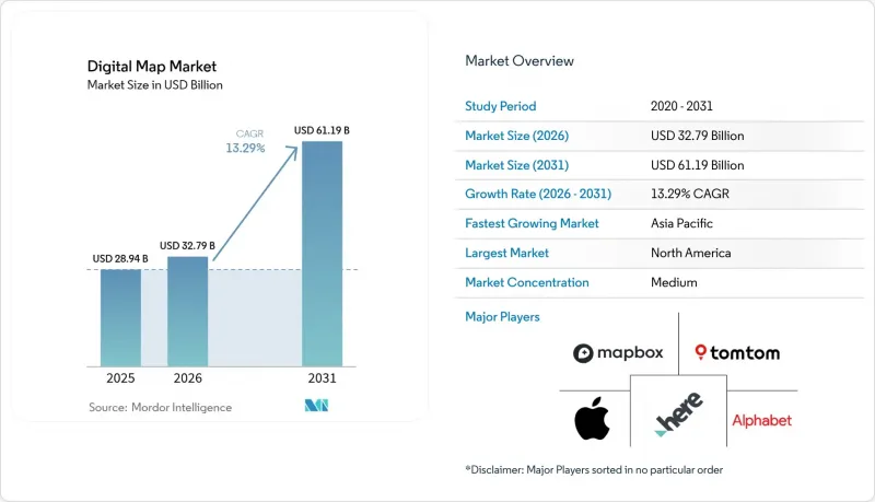
根據 Mordor Intelligence 預測,數位地圖市場規模預計將在 2025 年達到 289.4 億美元,2026 年達到 327.9 億美元,到 2031 年達到 611.9 億美元,2026 年至 2031 年的複合年成長率為 13.29%。
本報告按解決方案(軟體、服務)、部署方式(本地部署、雲端部署)、地圖類型(導航地圖、高清即時地圖、地形圖、專題地圖)、最終用戶產業(汽車、工程建設及其他)和地區(北美、南美、歐洲、亞太、中東和非洲)進行細分。市場預測以美元計價。
全球數位地圖市場趨勢與洞察
高清地圖在ADAS和自動駕駛汽車領域的快速普及。
目前,正在實施 SAE L3 和 L4 級自動駕駛功能的汽車製造商將厘米級精度的 HD 高清底圖視為必不可少的安全設備。梅賽德斯-奔馳已在加利福尼亞州和內華達州運作了“Drive Pilot”駕駛輔助系統,該系統採用 HERE 公司的“HD Live Map”高清即時地圖技術,融合了超過 500 萬輛車的感測器數據,將車道線精度控制在 10 厘米以內。 BMW和大眾的「動態地圖平台」每天處理 15 Terabyte的探測數據,更新覆蓋歐洲和日本 120 萬公里的地圖網路,凸顯了純LiDAR測繪的高昂成本。 SAE 於 2025 年發布的一份技術論文表明,將群眾外包更新資料疊加到靜態高清圖層上,可以在不影響精確度的前提下,將更新成本降低約 40%。這種混合模式正在推動對那些將車載感測器融合與雲端分析相結合的供應商的投資,而不是依賴定期的現場測繪。
聯網汽車的OTA地圖更新生態系統呈現爆炸性成長
隨著駕駛員和安全監管機構對最新道路數據的需求日益成長,空中下載 (OTA) 已從一項高級附加功能轉變為監管標準。福特在 2024 年交付了 6,300 萬個Delta壓縮地圖包,將蜂窩數據傳輸減少了 85%,並顯著降低了數據成本。 Stellantis 整合了驍龍 Ride Flex 晶片,讓車輛充電時也能自動進行更新,消除了以往阻礙關鍵補丁應用的延遲。特斯拉每月收集 15 億英里的車隊數據,並在無需向第三方支付版稅的情況下更新車道形狀,這表明垂直整合具有提高獲利能力的潛力。不願提供可與各種車載資訊系統無縫整合的輕量級 API 的地圖供應商,將面臨市場佔有率被構建自有數據管道的原始設備製造商 (OEM) 蠶食的風險。
與持續進行公分級地圖更新相關的成本不斷上升。
要在大陸公路網路上實現10公分以下的精度,需要大規模的LiDAR車隊、空拍影像和雲端處理——這些只有全球最大的公司才能負擔得起。 HERE公司擁有200輛雷射雷達車,但由於更新週期從每季縮短到每週,其高清服務的毛利率下降了320個基點。 TomTom公司減少了次市場的測繪頻率,轉而採用基於衛星的變化檢測技術,雖然成本降低了30%,但更新延遲也從幾天延長到了幾週。小規模的新興企業依賴電腦視覺技術開發行車記錄儀,但仍難以達到L4級精度目標。這些經濟因素進一步鞏固了老牌公司的競爭優勢,並減緩了產業的更迭速度。
細分市場分析
到2025年,軟體將佔據數位地圖市場64.33%的佔有率,這一地位是數十年來桌面GIS授權和嵌入式導航技術累積的結果。然而,從持續的地圖更新訂閱到雲端整合諮詢等業務收益,預計到2031年將以13.71%的複合年成長率成長,在此期間,服務收入將佔數位地圖市場成長的最大佔有率。如今,企業更傾向於可預測的營運成本模式,而非一次性資本投資。 Trimble於2024年收購了Transporeon,後者提供路線規劃API和物流諮詢服務,這使得Trimble在2025年上半年的訂閱合約年增了28%。 Esri和Maxar在面向市政機構的數位孿生專案中也報告了類似的趨勢,客戶強烈要求簽訂與續約頻率而非許可證數量掛鉤的、基於結果的合約。
向服務型企業的轉型也包含人才策略層面。由於很少公司擁有內部地理空間專家,他們會將資料整合、客製化地圖繪製和API管治等工作外包給能夠保證服務等級協定(SLA)的供應商。從絕對值來看,軟體仍然是最大的收入來源,但隨著雲端原生開放原始碼堆疊削弱其定價能力,授權收入的成長正在放緩。無法建立強大的諮詢或託管部門的供應商,可能會面臨市場佔有率被系統整合商和超大規模資料中心業者營運商蠶食的風險,因為後者已經建立了穩固的客戶關係。
2025年,雲端部署佔總營收的71.42%,預計到2031年將維持13.66%的複合年成長率。這將進一步鞏固整個數位地圖市場的「雲端優先」策略。 AWS Location Service透過單一的隨選計量收費終端提供來自HERE、Esri和Grab的地圖瓦片,讓企業避免與多家供應商談判相關的複雜性。 2025年3月,微軟更進一步,將Azure Maps整合到Power BI中,使分析師無需說明任何程式碼即可疊加銷售區域。這些措施將大幅降低採用門檻,加速非GIS專業用戶的採用,並將數位地圖市場的新佔有率推向雲端領域。
在國防、關鍵基礎設施和高度監管的公共產業領域,由於對資料主權和空氣間隙的要求始終不變,本地伺服器仍然十分普遍。 Esri 在 2025 年用戶大會上透露,約 30% 的 ArcGIS Enterprise 授權仍運作在客戶自己的伺服器上,低於 2020 年的 55%。隨著歐洲、印度和中東地區主權雲端區域的開放,預計部分工作負載也將遷移到雲端。分析師預測,到 2031 年,本地部署數位地圖的市場佔有率將穩定在 20-25%,這將為能夠滿足零連接要求的供應商創造一個專業但盈利的細分市場。
區域分析
預計到2025年,北美將佔全球數位地圖銷售額的36.83%,在基準年佔據數位地圖市場最大佔有率。加州和內華達州的自動駕駛汽車試驗正在推動數位地圖的普及,特斯拉大規模的車輛遙測數據以及美國國防部門雄厚的地理空間預算也功不可沒。美國聯邦通訊委員會(FCC)將於2024年分配「蜂窩車聯網(C-V2X)」頻段,這將加速聯網汽車的部署,並增加對即時交通和危險資訊圖層的需求。加拿大受惠於加拿大自然資源部提供的開放底圖,這降低了新創企業的進入門檻;而墨西哥則由於農村寬頻覆蓋率不足限制了雲端地理資訊系統(GIS)的普及,發展相對滯後。隨著聯網汽車普及率接近飽和,預計該地區的成長率將低於13.29%的全球平均複合年成長率(CAGR),但隨著國防機構更新高解析度地形數據,絕對支出預計仍將成長。
預計到2031年,亞太地區將以14.24%的複合年成長率(CAGR)實現最高成長,並在預測期內佔據數位地圖市場成長的最大佔有率。中國的百度地圖在整合了電動車充電樁位置和自動駕駛計程車路線導航功能後,於2024年第四季實現了6.5億月有效用戶。印度的智慧城市計畫要求所有100個指定市政當局部署用於廢棄物、交通和水資源管理的地理資訊系統(GIS)平台,為此,MapmyIndia和Esri India兩家公司簽訂了多年期合約。日本的Zenrin公司和豐田汽車公司正在合作,為L3級LexusTeammate自動駕駛汽車建立高精度地圖。韓國已累計5,000億韓元(約3.75億美元),用於在2027年釜山世博會之前將其道路網路數位化至10公分解析度。這些項目,加上5G的快速部署,正在推動該地區持續兩位數的成長。
預計到2025年,歐洲將佔據25%左右的市場佔有率,這主要得益於歐盟強制性的eCall計畫以及伽利略衛星定位精度的提升。 《數位市場法案》強制要求蘋果和谷歌開放地圖API,這項規定可能會將需求轉向HERE和TomTom等區域專業公司。嚴格的GDPR本地化要求有利於在法蘭克福和阿姆斯特丹擁有自主雲端的供應商,從而鞏固了現有公司的地位。在中東和非洲地區,阿拉伯聯合大公國和沙烏地阿拉伯正在投資建造智慧城市雙城項目,但由於缺乏地籍資料庫,撒哈拉以南非洲地區的部署受到限制。南美洲的需求集中在巴西和阿根廷,這兩個國家需要可靠的路線導航來支援城市物流平台,但外匯波動抑制了長期基礎設施投資。
其他好處:
- Excel格式的市場預測(ME)表
- 3個月的分析師支持
目錄
第1章:引言
- 市場分析與定義的前提條件
- 分析範圍
第2章 分析方法
第3章執行摘要
第4章 市場狀況
- 市場概覽
- 市場促進因素
- 高清地圖在ADAS和自動駕駛汽車領域的快速普及。
- 聯網汽車的OTA地圖更新生態系統呈現爆炸性成長
- 雲端原生GIS平台的主流化
- 智慧城市數位孿生計畫正在全球擴展。
- 歐盟強制實施eCall系統和下一代道路安全法規
- 企業範圍 3 碳排放映射要求
- 市場限制因素
- 地圖持續更新到公分級的成本越來越高。
- 加強資料保護和本地化方面的法律法規(GDPR、PIPL)
- 數據提供者與原始設備製造商之間的知識產權許可糾紛
- 人工智慧生成地圖中存在的演算法偏見和法律責任問題引發了人們的擔憂
- 產業價值鏈分析
- 監理情勢
- 技術展望
- 宏觀經濟因素對市場的影響
- 波特五力分析
第5章:預測市場規模與成長率
- 透過解決方案
- 軟體
- 服務
- 透過部署方法
- 現場
- 雲
- 按地圖類型
- 導航地圖
- 高清即時地圖
- 地形圖和專題地圖
- 按最終用途行業分類
- 車
- 工程與施工
- 溝通
- 公共部門/國防
- 零售和地理行銷
- 其他終端用戶產業
- 按地區
- 北美洲
- 美國
- 加拿大
- 墨西哥
- 南美洲
- 巴西
- 阿根廷
- 其他南美國家
- 歐洲
- 英國
- 德國
- 法國
- 義大利
- 其他歐洲國家
- 亞太地區
- 中國
- 日本
- 印度
- 韓國
- 其他亞太國家
- 中東和非洲
- 中東
- 阿拉伯聯合大公國
- 沙烏地阿拉伯
- 其他中東國家
- 非洲
- 南非
- 埃及
- 其他非洲國家
- 中東
- 北美洲
第6章 競爭情勢
- 市場集中度
- 策略趨勢
- 市佔率分析
- 公司簡介
- Alphabet Inc.
- HERE Global BV
- TomTom International BV
- Environmental Systems Research Institute, Inc.
- Mapbox, Inc.
- Apple Inc.
- Maxar Technologies Inc.
- Collins Bartholomew Limited
- Digital Map Products Inc.
- Digital Mapping Solutions Pty Ltd
- DMTI Spatial Inc.
- Lepton Software Export & Research(P)Ltd.
- ThinkGeo LLC
- MapData Services Pty Ltd
- NavInfo Co., Ltd.
- AutoNavi Holdings Limited
- Baidu Inc.
- Nearmap Ltd
- Zenrin Co., Ltd.
- Trimble Inc.
- CartoDB Inc.
- OpenStreetMap Foundation
- MapQuest, Inc.
第7章 市場機會與未來展望
According to Mordor Intelligence, the digital map market size is projected to be USD 28.94 billion in 2025, USD 32.79 billion in 2026, and reach USD 61.19 billion by 2031, growing at a CAGR of 13.29% from 2026 to 2031.
This report is Segmented by Solution (Software, and Services), Deployment (On-Premise, and Cloud), Map Type (Navigation Maps, HD and Real-Time Maps, Topographic and Thematic Maps), End-Use Industry (Automotive, Engineering and Construction, and More), and Geography (North America, South America, Europe, Asia-Pacific, Middle East and Africa). The Market Forecasts are Provided in Terms of Value (USD).
Global Digital Map Market Trends and Insights
Rapid Uptake of HD Maps for ADAS and Autonomous Vehicles
Automakers rolling out SAE Level 3 and Level 4 features now treat centimeter-grade HD basemaps as non-negotiable safety equipment. Mercedes-Benz activated Drive Pilot in California and Nevada using HERE's HD Live Map, which fuses sensor data from more than 5 million vehicles to keep lane markings accurate within 10 centimeters. BMW and Volkswagen's Dynamic Map Platform processes 15 terabytes of probe data each day to refresh a 1.2-million-kilometer European-Japanese network, revealing the high cost of pure LiDAR surveys. A 2025 SAE technical paper showed that overlaying crowd-sourced updates on a static HD layer can trim refresh expense by roughly 40% without losing accuracy. This hybrid model is steering investment toward providers that pair on-board sensor fusion with cloud analytics rather than rely on periodic drive-outs.
Explosive Growth of Connected-Car OTA Map-Update Ecosystems
Over-the-air delivery has moved from a premium add-on to a regulatory baseline as drivers and safety agencies demand up-to-the-minute road data. Ford pushed 63 million delta-compressed map packages in 2024, cutting cellular payloads 85% and slashing data costs. Stellantis embedded Snapdragon Ride Flex chips so updates run automatically while vehicles charge, eliminating the latency that once delayed critical patches. Tesla ingests 1.5 billion fleet miles each month, refreshing lane geometry without third-party royalties and proving the margin upside of vertical integration. Map vendors unwilling to offer lightweight APIs that integrate seamlessly with diverse telematics stacks risk losing share to OEMs writing their own pipelines.
Escalating Costs of Continuous, Centimeter-Level Map Refresh
Sub-10-centimeter accuracy across continental road networks demands heavy LiDAR fleets, aerial imagery, and cloud processing that only global incumbents can afford. HERE's 200-vehicle LiDAR armada cut gross margin on HD services by 320 basis points when refresh cycles tightened from quarterly to weekly. TomTom trimmed survey cadence in secondary markets and pivoted to satellite change detection, lowering costs 30% but stretching update latency from days to weeks. Smaller challengers rely on dash-cam computer vision yet still struggle to meet Level 4 precision targets. The economics widen incumbents' moats and slow competitive churn.
Other drivers and restraints analyzed in the detailed report include:
- Mainstream Adoption of Cloud-Native GIS Platforms
- Smart-City Digital-Twin Programs Scaling Globally
- Heightened Data-Privacy and Localization Statutes (GDPR, PIPL)
For complete list of drivers and restraints, kindly check the Table Of Contents.
Segment Analysis
Software accounted for 64.33% of the digital map market share in 2025, a position built on decades of desktop GIS licenses and embedded navigation stacks. Even so, service revenues, ranging from continuous map-refresh subscriptions to cloud-integration consulting, are forecast to climb at a 13.71% CAGR through 2031, adding the largest slice of the incremental digital map market over the period. Enterprises now favor predictable operating expense models over one-time capital outlays; Trimble's 2024 purchase of Transporeon, which bundles routing APIs with logistics consulting, produced a 28% year-over-year lift in subscription lines during 1H 2025. Esri and Maxar report the same pattern in municipal digital-twin engagements, where customers insist on outcome-based contracts tied to refresh frequency rather than seat counts.
The tilt toward services is also a talent play. Few enterprises employ in-house geospatial experts, so they outsource data fusion, custom cartography, and API governance to suppliers that can guarantee service-level agreements. Software will remain the larger revenue pool in absolute terms, but licensing growth is decelerating as cloud-native open-source stacks undercut pricing power. Vendors that fail to build substantial consulting and managed-hosting arms risk ceding wallet share to systems integrators or hyperscalers that already command the customer relationship.
Cloud installations accounted for 71.42% of 2025 revenue and are projected to maintain a 13.66% CAGR through 2031, reinforcing a cloud-first stance across the digital map market. With AWS Location Service exposing HERE, Esri, and Grab tiles behind a single pay-as-you-go endpoint, enterprises avoid the complexity of multiple negotiations. Microsoft went further in March 2025, embedding Azure Maps inside Power BI so analysts can overlay sales territories without writing code. These moves slash deployment friction and accelerate adoption among non-GIS specialists, driving new chunks of the digital map market size into the cloud column.
On-premises servers persist in defense, critical infrastructure, and heavily regulated utilities where sovereign data or air-gap mandates remain immovable. Esri disclosed at its 2025 user conference that roughly 30% of ArcGIS Enterprise seats still run on customer metal, down from 55% in 2020. As sovereign cloud regions open in Europe, India, and the Middle East, even some of those workloads are expected to migrate. By 2031, analysts see on-premises stabilizing at 20-25% of the digital map market share, anchoring a specialized but profitable niche for vendors able to meet zero-connectivity requirements.
Complete Report Scope:
- By Solution
- Software
- Services
- By Deployment
- On-Premise
- Cloud
- By Map Type
- Navigation Maps
- HD and Real-Time Maps
- Topographic and Thematic Maps
- By End-Use Industry
- Automotive
- Engineering and Construction
- Telecommunications
- Public Sector and Defense
- Retail and Geomarketing
- Other End-Use Industries
- By Geography
- North America
- United States
- Canada
- Mexico
- South America
- Brazil
- Argentina
- Rest of South America
- Europe
- United Kingdom
- Germany
- France
- Italy
- Rest of Europe
- Asia Pacific
- China
- Japan
- India
- South Korea
- Rest of Asia Pacific
- Middle East and Africa
- Middle East
- United Arab Emirates
- Saudi Arabia
- Rest of Middle East
- Africa
- South Africa
- Egypt
- Rest of Africa
- Middle East
- North America
Geography Analysis
North America accounted for 36.83% of 2025 revenue, giving the region the largest share of the digital map market in the base year. Autonomous-vehicle pilots in California and Nevada drive uptake, Tesla's high-volume fleet telemetry, and robust U.S. defense geospatial budgets. The Federal Communications Commission's 2024 allocation of Cellular Vehicle-to-Everything spectrum accelerated connected-car deployments and boosted demand for real-time traffic and hazard layers. Canada benefits from Natural Resources Canada's open basemaps, which lower entry barriers for start-ups, while Mexico lags because rural broadband gaps limit cloud GIS adoption. As connected-vehicle penetration nears saturation, regional growth is expected to trail the 13.29% global CAGR, but absolute spending will still expand as defense agencies refresh HD terrain data.
Asia-Pacific is projected to post the fastest 14.24% CAGR through 2031 and will add the largest share of the incremental digital map market over the forecast window. China's Baidu Maps recorded 650 million monthly active users in Q4 2024 after integrating EV-charger availability and autonomous-taxi routing. India's Smart Cities Mission requires all 100 designated municipalities to deploy GIS platforms for waste, mobility, and water management, feeding multiyear contracts to MapmyIndia and Esri India. Japan's Zenrin-Toyota partnership is building HD maps for Level 3 Lexus Teammate, while South Korea earmarked KRW 500 billion (USD 375 million) to digitize its road grid at 10-centimeter resolution ahead of the 2027 Busan World Expo. These programs, combined with rapid 5G rollout, underpin sustained double-digit regional growth.
Europe captured a mid-20s share in 2025, supported by the EU's eCall mandate and improvements in Galileo satellite accuracy. The Digital Markets Act now obliges Apple and Google to open mapping APIs, a rule that could redirect traffic to regional specialists such as HERE and TomTom. Strict GDPR localization favors vendors with sovereign clouds in Frankfurt and Amsterdam, reinforcing incumbent positions. In the Middle East and Africa, the United Arab Emirates and Saudi Arabia bankroll smart-city twins, yet sub-Saharan African adoption is constrained by limited cadastral databases. South American demand is centered on Brazil and Argentina, where urban logistics platforms need reliable routing, but currency volatility tempers long-horizon infrastructure investment.
- Alphabet Inc.
- HERE Global B.V.
- TomTom International B.V.
- Environmental Systems Research Institute, Inc.
- Mapbox, Inc.
- Apple Inc.
- Maxar Technologies Inc.
- Collins Bartholomew Limited
- Digital Map Products Inc.
- Digital Mapping Solutions Pty Ltd
- DMTI Spatial Inc.
- Lepton Software Export & Research (P) Ltd.
- ThinkGeo LLC
- MapData Services Pty Ltd
- NavInfo Co., Ltd.
- AutoNavi Holdings Limited
- Baidu Inc.
- Nearmap Ltd
- Zenrin Co., Ltd.
- Trimble Inc.
- CartoDB Inc.
- OpenStreetMap Foundation
- MapQuest, Inc.
Additional Benefits:
- The market estimate (ME) sheet in Excel format
- 3 months of analyst support
TABLE OF CONTENTS
1 INTRODUCTION
- 1.1 Study Assumptions and Market Definition
- 1.2 Scope of the Study
2 RESEARCH METHODOLOGY
3 EXECUTIVE SUMMARY
4 MARKET LANDSCAPE
- 4.1 Market Overview
- 4.2 Market Drivers
- 4.2.1 Rapid Uptake of HD Maps for ADAS and Autonomous Vehicles
- 4.2.2 Explosive Growth of Connected-Car OTA Map-Update Ecosystems
- 4.2.3 Mainstream Adoption of Cloud-Native GIS Platforms
- 4.2.4 Smart-City Digital-Twin Programs Scaling Globally
- 4.2.5 Mandatory EU eCall and Next-Gen Road-Safety Regulations
- 4.2.6 Corporate Scope-3 Carbon Mapping Requirements
- 4.3 Market Restraints
- 4.3.1 Escalating Costs of Continuous, Centimetre-Level Map Refresh
- 4.3.2 Heightened Data-Privacy and Localization Statutes (GDPR, PIPL)
- 4.3.3 IP-Licensing Disputes Among Data Providers and OEMs
- 4.3.4 Algorithmic Bias and Liability Concerns in AI-Generated Maps
- 4.4 Industry Value Chain Analysis
- 4.5 Regulatory Landscape
- 4.6 Technological Outlook
- 4.7 Impact of Macroeconomic Factors on the Market
- 4.8 Porter's Five Forces Analysis
- 4.8.1 Threat of New Entrants
- 4.8.2 Bargaining Power of Buyers
- 4.8.3 Bargaining Power of Suppliers
- 4.8.4 Threat of Substitutes
- 4.8.5 Intensity of Competitive Rivalry
5 MARKET SIZE AND GROWTH FORECASTS (VALUE)
- 5.1 By Solution
- 5.1.1 Software
- 5.1.2 Services
- 5.2 By Deployment
- 5.2.1 On-Premise
- 5.2.2 Cloud
- 5.3 By Map Type
- 5.3.1 Navigation Maps
- 5.3.2 HD and Real-Time Maps
- 5.3.3 Topographic and Thematic Maps
- 5.4 By End-Use Industry
- 5.4.1 Automotive
- 5.4.2 Engineering and Construction
- 5.4.3 Telecommunications
- 5.4.4 Public Sector and Defense
- 5.4.5 Retail and Geomarketing
- 5.4.6 Other End-Use Industries
- 5.5 By Geography
- 5.5.1 North America
- 5.5.1.1 United States
- 5.5.1.2 Canada
- 5.5.1.3 Mexico
- 5.5.2 South America
- 5.5.2.1 Brazil
- 5.5.2.2 Argentina
- 5.5.2.3 Rest of South America
- 5.5.3 Europe
- 5.5.3.1 United Kingdom
- 5.5.3.2 Germany
- 5.5.3.3 France
- 5.5.3.4 Italy
- 5.5.3.5 Rest of Europe
- 5.5.4 Asia Pacific
- 5.5.4.1 China
- 5.5.4.2 Japan
- 5.5.4.3 India
- 5.5.4.4 South Korea
- 5.5.4.5 Rest of Asia Pacific
- 5.5.5 Middle East and Africa
- 5.5.5.1 Middle East
- 5.5.5.1.1 United Arab Emirates
- 5.5.5.1.2 Saudi Arabia
- 5.5.5.1.3 Rest of Middle East
- 5.5.5.2 Africa
- 5.5.5.2.1 South Africa
- 5.5.5.2.2 Egypt
- 5.5.5.2.3 Rest of Africa
- 5.5.5.1 Middle East
- 5.5.1 North America
6 COMPETITIVE LANDSCAPE
- 6.1 Market Concentration
- 6.2 Strategic Moves
- 6.3 Market Share Analysis
- 6.4 Company Profiles (includes Global Level Overview, Market Level Overview, Core Segments, Financials as available, Strategic Information, Market Rank/Share, Products and Services, Recent Developments)
- 6.4.1 Alphabet Inc.
- 6.4.2 HERE Global B.V.
- 6.4.3 TomTom International B.V.
- 6.4.4 Environmental Systems Research Institute, Inc.
- 6.4.5 Mapbox, Inc.
- 6.4.6 Apple Inc.
- 6.4.7 Maxar Technologies Inc.
- 6.4.8 Collins Bartholomew Limited
- 6.4.9 Digital Map Products Inc.
- 6.4.10 Digital Mapping Solutions Pty Ltd
- 6.4.11 DMTI Spatial Inc.
- 6.4.12 Lepton Software Export & Research (P) Ltd.
- 6.4.13 ThinkGeo LLC
- 6.4.14 MapData Services Pty Ltd
- 6.4.15 NavInfo Co., Ltd.
- 6.4.16 AutoNavi Holdings Limited
- 6.4.17 Baidu Inc.
- 6.4.18 Nearmap Ltd
- 6.4.19 Zenrin Co., Ltd.
- 6.4.20 Trimble Inc.
- 6.4.21 CartoDB Inc.
- 6.4.22 OpenStreetMap Foundation
- 6.4.23 MapQuest, Inc.
7 MARKET OPPORTUNITIES AND FUTURE OUTLOOK
- 7.1 White-Space and Unmet-Need Assessment

 數位地圖市場-2026-2032年全球市場預測
 數位地圖市場報告:按類型、應用、解決方案、部署模式、應用領域、最終用戶產業和地區分類(2026-2034 年)
 數位地圖市場分析及預測(至2035年):類型、產品類型、服務、技術、組件、應用、部署模式、最終用戶
 2026年全球數位地圖市場報告
 全球數位地圖市場規模、佔有率、趨勢和成長分析報告(2026-2034)全球數位地圖服務市場規模、佔有率、趨勢和成長分析報告(2026-2034年)
 數位地圖市場-全球產業規模、佔有率、趨勢、機會及預測(按組件、部署類型、技術、應用、最終用戶、地區和競爭格局分類),2021-2031年網路視覺化軟體市場:按公司規模、解決方案類型、組件、部署模式、應用和行業垂直領域分類 - 全球預測(2026-2032 年)
 全球數位地圖市場(按解決方案和用例)預測(至 2030 年)
 2025-2029年全球數位地圖市場