


 |
市場調查報告書
商品編碼
1797753
衛星地球觀測市場機會、成長動力、產業趨勢分析及 2025 - 2034 年預測Satellite-Based Earth Observation Market Opportunity, Growth Drivers, Industry Trend Analysis, and Forecast 2025 - 2034 |
||||||
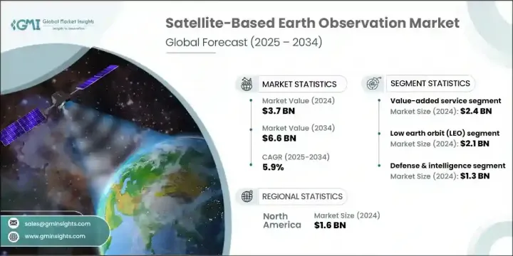
2024 年全球衛星對地觀測市場價值為 37 億美元,預計到 2034 年將以 5.9% 的複合年成長率成長至 66 億美元。氣候監測、國家安全和環境應用對地理空間情報的日益依賴推動了持續的需求。衛星小型化的進步和部署成本的降低極大地促進了小型衛星的部署。這些緊湊型平台可為農業、國防和災難應變等多個領域提供經濟高效的高解析度資料。人工智慧和雲端運算在將原始衛星圖像轉換為可操作資料方面發揮關鍵作用,從而增強了產業和政府的決策能力。由於全球致力於監測氣候模式、最佳化城市發展和提高抵禦自然災害的能力,需求也在上升。
更高的精度、更短的資料傳輸週期以及更方便的複雜分析平台,持續推動市場的發展,使人們能夠近乎即時地洞察地表狀況。這些改進大幅縮短了資料收集與可操作決策之間的時間間隔,使農業、環境保護、城市規劃和緊急管理等領域的利害關係人能夠更有效地應對挑戰。衛星資料與人工智慧和機器學習的結合,進一步增強了探測細微環境變化、監測基礎設施、評估作物健康狀況以及以前所未有的精度追蹤森林砍伐或污染的能力。
| 市場範圍 | |
|---|---|
| 起始年份 | 2024 |
| 預測年份 | 2025-2034 |
| 起始值 | 37億美元 |
| 預測值 | 66億美元 |
| 複合年成長率 | 5.9% |
加值服務領域在2024年創造了24億美元的收入。這一成長源於對基於衛星資料的客製化分析日益成長的需求。這些洞察支持基礎設施、能源、智慧城市和農業等關鍵領域的更智慧的規劃和營運。人工智慧平台的整合以及與分析提供者的合作,能夠在環境追蹤和城市發展等領域提供更具體的解決方案。透過統一平台簡化分析訪問,可以提高採用率,尤其是在尋求快速、直覺和可靠資訊傳遞系統的用戶中。
2024年,低地球軌道(LEO)市值達21億美元。小型衛星和緊湊型立方體衛星的興起促進了這一成長,因為這些平台能夠提供高解析度影像和快速重訪間隔。高頻成像支援土地利用測繪、作物健康追蹤和緊急應變等應用。發射供應商與衛星公司之間的合作改善了獲取途徑,並降低了營運成本。這些優勢加速了商業和公眾對詳細、持續的地球觀測的興趣,尤其是在國防、永續發展和環境監測等領域。
2024年,美國衛星對地觀測市場產值達13.8億美元。這一領先地位源自於對衛星創新和國家安全技術的大規模投資。企業必須使其產品與災害應變、氣候資料收集和策略監視方面不斷變化的需求保持一致。重視整合人工智慧驅動的資料分析、基於雲端的交付模式和安全通訊系統,將進一步提升供應商在未來政府合約和商業合作中保持競爭力的優勢。
全球衛星對地觀測市場的主要參與者包括 Planet Labs PBC、MinoSpace、GeoOptics Inc.、ICEYE Oy、Capella Space Inc.、OroraTech GmbH、空中巴士防務與航太、Spire Global, Inc.、ImageSat International NV、Maxar Technologies Inc.、BlackSky Technology Inc.、LiveSky Technology Inc. Ltd.。為了加強在衛星對地觀測市場的地位,各公司正專注於整合人工智慧和機器學習演算法,以實現更智慧的資料解讀。許多公司正在與分析公司建立合作夥伴關係,共同開發針對國防、農業和環境監測等特定行業的客製化服務。擴大小型衛星星座可以實現更廣泛的覆蓋範圍和更頻繁的資料收集。
目錄
第1章:方法論與範圍
第2章:執行摘要
第3章:行業洞察
- 產業生態系統分析
- 供應商格局
- 利潤率
- 成本結構
- 每個階段的增值
- 影響價值鏈的因素
- 中斷
- 產業生態系統分析
- 產業衝擊力
- 成長動力
- 地理空間資料的需求不斷增加
- 氣候變遷監測
- 政府和國防應用
- 雲端運算和人工智慧分析的普及
- 衛星小型化進展
- 陷阱與挑戰
- 高昂的初始投資和啟動成本
- 軌道碎片和空間堵塞
- 成長動力
- 成長潛力分析
- 監管格局
- 北美洲
- 歐洲
- 亞太地區
- 拉丁美洲
- 中東和非洲
- 波特的分析
- PESTEL分析
- 科技與創新格局
- 當前的技術趨勢
- 新興技術
- 新興商業模式
- 合規性要求
- 國防預算分析
- 全球國防開支趨勢
- 區域國防預算分配
- 北美洲
- 歐洲
- 亞太地區
- 中東和非洲
- 拉丁美洲
- 重點國防現代化項目
- 預算預測(2025-2034)
- 對產業成長的影響
- 各國國防預算
- 供應鏈彈性
- 地緣政治分析
- 勞動力分析
- 數位轉型
- 合併、收購和策略夥伴關係格局
- 風險評估與管理
- 主要合約授予(2021-2024)
第4章:競爭格局
- 介紹
- 公司市佔率分析
- 按地區
- 北美洲
- 歐洲
- 亞太地區
- 拉丁美洲
- 中東和非洲
- 市場集中度分析
- 按地區
- 關鍵參與者的競爭基準
- 財務績效比較
- 收入
- 利潤率
- 研發
- 產品組合比較
- 產品範圍廣度
- 科技
- 創新
- 地理位置比較
- 全球足跡分析
- 服務網路覆蓋
- 各區域市場滲透率
- 競爭定位矩陣
- 領導者
- 挑戰者
- 追蹤者
- 利基市場參與者
- 戰略展望矩陣
- 財務績效比較
- 2021-2024 年關鍵發展
- 併購
- 夥伴關係和合作
- 技術進步
- 擴張和投資策略
- 永續發展舉措
- 數位轉型舉措
- 新興/新創企業競爭對手格局
第5章:市場估計與預測:依產品類型,2021 - 2034 年
- 主要趨勢
- EO數據
- 光學成像資料
- 雷達圖像資料
- 高光譜影像資料
- 熱紅外線成像資料
- 其他
- 加值服務
- 分析與洞察服務
- 地理空間情報平台
- 其他
第6章:市場估計與預測:按衛星軌道,2021 - 2034 年
- 主要趨勢
- 低地球軌道(LEO)
- 中地球軌道(MEO)
- 地球靜止軌道(GEO)
第7章:市場估計與預測:按技術,2021 - 2034 年
- 主要趨勢
- 光學(電光)
- 合成孔徑雷達(SAR)
- 高光譜和多光譜
- 熱紅外線感測器
- LiDAR 系統
- 其他
第8章:市場估計與預測:按應用,2021 - 2034 年
- 主要趨勢
- 農業和林業
- 國防與情報
- 環境與氣候監測
- 都市與基礎建設規劃
- 能源、採礦和自然資源
- 海運與運輸
- 其他
第9章:市場估計與預測:依最終用途,2021 - 2034 年
- 主要趨勢
- 政府和國防
- 軍事和情報機構
- 民政和公共安全部門
- 商業的
- 農業綜合企業及林業公司
- 環境服務提供者
- 建築和城市規劃公司
- 能源和礦業公司
- 海上物流營運商
- 其他
- 研究與學術
- 其他
第 10 章:市場估計與預測:按地區,2021 年至 2034 年
- 主要趨勢
- 北美洲
- 美國
- 加拿大
- 歐洲
- 德國
- 英國
- 法國
- 西班牙
- 義大利
- 荷蘭
- 亞太地區
- 中國
- 印度
- 日本
- 澳洲
- 韓國
- 拉丁美洲
- 巴西
- 墨西哥
- 阿根廷
- 中東和非洲
- 沙烏地阿拉伯
- 南非
- 阿拉伯聯合大公國
第 11 章:公司簡介
- Global Key Players
- Regional Key Players
- 顛覆者/利基市場參與者
- 卡佩拉太空公司
- Pixel公司
- 奧羅拉技術有限公司
- UrtheCast 公司
- GeoOptics公司
The Global Satellite-Based Earth Observation Market was valued at USD 3.7 billion in 2024 and is estimated to grow at a CAGR of 5.9% to reach USD 6.6 billion by 2034. Increasing reliance on geospatial intelligence for climate surveillance, national security, and environmental applications is driving consistent demand. Advancements in satellite miniaturization and lower deployment costs have significantly boosted the deployment of smaller satellites. These compact platforms deliver cost-effective, high-resolution data across several sectors, including agriculture, defense, and disaster response. Artificial intelligence and cloud computing play a pivotal role in transforming raw satellite imagery into actionable data, thereby enhancing decision-making for industries and governments alike. Demand is also rising due to global efforts aimed at monitoring climate patterns, optimizing urban growth, and improving resilience to natural disasters.
Enhanced accuracy, shorter data delivery cycles, and easy access to sophisticated analytics platforms continue to push the market forward, enabling near real-time insights into Earth's surface conditions. These improvements are drastically reducing the time between data collection and actionable decision-making, allowing stakeholders in sectors such as agriculture, environmental conservation, urban planning, and emergency management to respond more effectively. The integration of satellite data with AI and machine learning has further amplified the ability to detect subtle environmental changes, monitor infrastructure, assess crop health, and track deforestation or pollution with unprecedented precision.
| Market Scope | |
|---|---|
| Start Year | 2024 |
| Forecast Year | 2025-2034 |
| Start Value | $3.7 billion |
| Forecast Value | $6.6 billion |
| CAGR | 5.9% |
The value-added services segment generated USD 2.4 billion in 2024. This growth is tied to the increasing requirement for customized analysis derived from satellite data. These insights support smarter planning and operations in key sectors such as infrastructure, energy, smart cities, and agriculture. Integration of AI-powered platforms and partnerships with analytics providers allows for more specific solutions in areas like environmental tracking and city development. Simplified access to analytics through unified platforms increases adoption, especially among users seeking fast, intuitive, and reliable information delivery systems.
The low Earth orbit (LEO) segment was valued at USD 2.1 billion in 2024. The rise of small satellites and compact CubeSats contributes to this growth, as these platforms deliver high-resolution visuals and rapid revisit intervals. Frequent imaging supports applications such as land use mapping, crop health tracking, and emergency response. Collaboration between launch providers and satellite firms has improved access and reduced operational costs. These advantages have accelerated the expansion of commercial and public interest in detailed, constant Earth observation, especially across defense, sustainability, and environmental monitoring initiatives.
United States Satellite-Based Earth Observation Market generated USD 1.38 billion in 2024. This leadership stems from large-scale investment in satellite innovation and national security technologies. Companies must align their product offerings with evolving needs in disaster readiness, climate data gathering, and strategic surveillance. Emphasis on integrating AI-driven data analysis, cloud-based delivery models, and secure communications systems will further enhance the positioning of vendors seeking to remain competitive in future government contracts and commercial engagements.
Key participants in the Global Satellite-Based Earth Observation Market include Planet Labs PBC, MinoSpace, GeoOptics Inc., ICEYE Oy, Capella Space Inc., OroraTech GmbH, Airbus Defence and Space, Spire Global, Inc., ImageSat International N.V., Maxar Technologies Inc., BlackSky Technology Inc., LiveEO GmbH, L3Harris Technologies Inc., China Siwei Surveying and Mapping Technology Co., Ltd., and MDA Space Ltd. To strengthen their presence in the satellite-based Earth observation market, companies are focusing on integrating AI and machine learning algorithms for more intelligent data interpretation. Many are forming partnerships with analytics firms to co-develop customized services tailored to specific industries like defense, agriculture, and environmental monitoring. Expanding constellations of smaller satellites enables broader coverage and more frequent data collection.
Table of Contents
Chapter 1 Methodology and scope
- 1.1 Market scope and definition
- 1.2 Research design
- 1.2.1 Research approach
- 1.2.2 Data collection methods
- 1.3 Data mining sources
- 1.3.1 Global
- 1.3.2 Regional/Country
- 1.4 Base estimates and calculations
- 1.4.1 Base year calculation
- 1.4.2 Key trends for market estimation
- 1.5 Primary research and validation
- 1.5.1 Primary sources
- 1.6 Forecast model
- 1.7 Research assumptions and limitations
Chapter 2 Executive summary
- 2.1 Industry 3600 synopsis
- 2.2 Key market trends
- 2.2.1 Product type trends
- 2.2.2 Satellite orbit trends
- 2.2.3 Technology trends
- 2.2.4 Application trends
- 2.2.5 End use trends
- 2.2.6 Regional trends
- 2.3 TAM Analysis, 2025-2034 (USD Billion)
- 2.4 CXO perspectives: Strategic imperatives
- 2.4.1 Executive decision points
- 2.4.2 critical success factors
- 2.5 Future outlook and strategic recommendations
Chapter 3 Industry insights
- 3.1 Industry ecosystem analysis
- 3.1.1 Supplier landscape
- 3.1.2 Profit margin
- 3.1.3 Cost structure
- 3.1.4 Value addition at each stage
- 3.1.5 Factor affecting the value chain
- 3.1.6 Disruptions
- 3.2 Industry ecosystem analysis
- 3.3 Industry impact forces
- 3.3.1 Growth drivers
- 3.3.1.1 Increasing demand for geospatial data
- 3.3.1.2 Climate change monitoring
- 3.3.1.3 Government and defense applications
- 3.3.1.4 Proliferation of cloud computing and AI analytics
- 3.3.1.5 Advancements in satellite miniaturization
- 3.3.2 Pitfalls and challenges
- 3.3.2.1 High Initial Investment and Launch Costs
- 3.3.2.2 Orbital Debris and Space Congestion
- 3.3.1 Growth drivers
- 3.4 Growth potential analysis
- 3.5 Regulatory landscape
- 3.5.1 North America
- 3.5.2 Europe
- 3.5.3 Asia Pacific
- 3.5.4 Latin America
- 3.5.5 Middle East & Africa
- 3.6 Porter's analysis
- 3.7 PESTEL analysis
- 3.8 Technology and Innovation landscape
- 3.8.1 Current technological trends
- 3.8.2 Emerging technologies
- 3.9 Emerging business models
- 3.10 Compliance requirements
- 3.11 Defense budget analysis
- 3.12 Global defense spending trends
- 3.13 Regional defense budget allocation
- 3.13.1 North America
- 3.13.2 Europe
- 3.13.3 Asia Pacific
- 3.13.4 Middle East and Africa
- 3.13.5 Latin America
- 3.14 Key defense modernization programs
- 3.15 Budget forecast (2025-2034)
- 3.15.1 Impact on industry growth
- 3.15.2 Defense budgets by country
- 3.16 Supply chain resilience
- 3.17 Geopolitical analysis
- 3.18 Workforce analysis
- 3.19 Digital transformation
- 3.20 Mergers, acquisitions, and strategic partnerships landscape
- 3.21 Risk assessment and management
- 3.22 Major contract awards (2021-2024)
Chapter 4 Competitive landscape, 2024
- 4.1 Introduction
- 4.2 Company market share analysis
- 4.2.1 By region
- 4.2.1.1 North America
- 4.2.1.2 Europe
- 4.2.1.3 Asia Pacific
- 4.2.1.4 Latin America
- 4.2.1.5 Middle East & Africa
- 4.2.2 Market Concentration Analysis
- 4.2.1 By region
- 4.3 Competitive benchmarking of key players
- 4.3.1 Financial performance comparison
- 4.3.1.1 Revenue
- 4.3.1.2 Profit margin
- 4.3.1.3 R&D
- 4.3.2 Product portfolio comparison
- 4.3.2.1 Product range breadth
- 4.3.2.2 Technology
- 4.3.2.3 Innovation
- 4.3.3 Geographic presence comparison
- 4.3.3.1 Global footprint analysis
- 4.3.3.2 Service network coverage
- 4.3.3.3 Market penetration by region
- 4.3.4 Competitive positioning matrix
- 4.3.4.1 Leaders
- 4.3.4.2 Challengers
- 4.3.4.3 Followers
- 4.3.4.4 Niche players
- 4.3.5 Strategic outlook matrix
- 4.3.1 Financial performance comparison
- 4.4 Key developments, 2021-2024
- 4.4.1 Mergers and acquisitions
- 4.4.2 Partnerships and collaborations
- 4.4.3 Technological advancements
- 4.4.4 Expansion and investment strategies
- 4.4.5 Sustainability initiatives
- 4.4.6 Digital transformation initiatives
- 4.5 Emerging/ startup competitors landscape
Chapter 5 Market estimates and forecast, By Product Type, 2021 - 2034 (USD Million)
- 5.1 Key trends
- 5.2 EO Data
- 5.2.1 Optical imaging data
- 5.2.2 Radar imaging data
- 5.2.3 Hyperspectral imaging data
- 5.2.4 Thermal infrared imaging data
- 5.2.5 Others
- 5.3 Value-added services
- 5.3.1 Analytics & Insight Services
- 5.3.2 Geospatial Intelligence Platforms
- 5.3.3 Others
Chapter 6 Market estimates and forecast, By Satellite Orbit, 2021 - 2034 (USD Million)
- 6.1 Key trends
- 6.2 Low earth orbit (LEO)
- 6.3 Medium earth orbit (MEO)
- 6.4 Geostationary orbit (GEO)
Chapter 7 Market estimates and forecast, By Technology, 2021 - 2034 (USD Million)
- 7.1 Key trends
- 7.2 Optical (electro-optical)
- 7.3 Synthetic aperture radar (SAR)
- 7.4 Hyperspectral & multispectral
- 7.5 Thermal infrared sensors
- 7.6 LiDAR systems
- 7.7 Others
Chapter 8 Market estimates and forecast, By Application, 2021 - 2034 (USD Million)
- 8.1 Key trends
- 8.2 Agriculture & forestry
- 8.3 Defense & intelligence
- 8.4 Environmental & climate monitoring
- 8.5 Urban & infrastructure planning
- 8.6 Energy, mining & natural resources
- 8.7 Maritime & transportation
- 8.8 Others
Chapter 9 Market estimates and forecast, By End Use, 2021 - 2034 (USD Million)
- 9.1 Key trends
- 9.2 Government & defense
- 9.2.1 Military & intelligence agencies
- 9.2.2 Civil government & public safety departments
- 9.3 Commercial
- 9.3.1 Agribusiness & forestry companies
- 9.3.2 Environmental service providers
- 9.3.3 Construction & urban planning firms
- 9.3.4 Energy & mining companies
- 9.3.5 Maritime logistics operators
- 9.3.6 Others
- 9.4 Research & academia
- 9.5 Others
Chapter 10 Market estimates and forecast, By Region, 2021 - 2034 (USD Million)
- 10.1 Key trends
- 10.2 North America
- 10.2.1 U.S.
- 10.2.2 Canada
- 10.3 Europe
- 10.3.1 Germany
- 10.3.2 UK
- 10.3.3 France
- 10.3.4 Spain
- 10.3.5 Italy
- 10.3.6 Netherlands
- 10.4 Asia Pacific
- 10.4.1 China
- 10.4.2 India
- 10.4.3 Japan
- 10.4.4 Australia
- 10.4.5 South Korea
- 10.5 Latin America
- 10.5.1 Brazil
- 10.5.2 Mexico
- 10.5.3 Argentina
- 10.6 Middle East and Africa
- 10.6.1 Saudi Arabia
- 10.6.2 South Africa
- 10.6.3 UAE
Chapter 11 Company profiles
- 11.1 Global Key Players
- 11.1.1 Maxar Technologies Inc.
- 11.1.2 Airbus Defence and Space
- 11.1.3 Planet Labs PBC
- 11.1.4 ImageSat International N.V.
- 11.1.5 Spire Global Inc
- 11.2 Regional Key Players
- 11.2.1 North America
- 11.2.1.1 BlackSky Technology Inc.
- 11.2.1.2 L3Harris Technologies Inc
- 11.2.1.3 MDA Space Ltd.
- 11.2.2 Europe
- 11.2.2.1 LiveEO GmbH
- 11.2.2.2 Satellite Vu Ltd.
- 11.2.2.3 ICEYE Oy
- 11.2.3 Asia-Pacific
- 11.2.3.1 SpaceWill Information Co., Ltd.
- 11.2.3.2 MinoSpace
- 11.2.3.3 XRTech Group
- 11.2.3.4 China Siwei Surveying and Mapping Technology Co., Ltd.
- 11.2.1 North America
- 11.3 Disruptors / Niche Players
- 11.3.1 Capella Space Inc.
- 11.3.2 Pixxel Inc
- 11.3.3 OroraTech GmbH
- 11.3.4 UrtheCast Corp.
- 11.3.5 GeoOptics Inc.
 2026年全球衛星地球觀測市場報告
 衛星地球觀測市場:2026-2030年全球市場預測(依產品類型、衛星軌道、解析度、衛星群配置、資料等級、感測器類型、技術、應用、授權模式和最終用戶分類)地球觀測無人機市場:按組件、平台類型、機載設備類型、應用和最終用戶分類-2026-2032年全球市場預測觀察管市場:按產品類型、技術、分銷管道、應用和最終用戶分類的全球預測,2026-2032年
 地球觀測市場規模、佔有率、成長及全球產業分析:按類型、應用和地區的洞察,2026-2034年預測
 衛星地球觀測:政府與軍事戰略
 衛星地球觀測的全球市場:趨勢與預測(2024年~2034年)
 全球地球觀測市場:市場規模、佔有率、趨勢分析(按平台、軌道類型、技術、應用和地區)、細分市場預測(2025-2030 年)
 衛星對地觀測市場:商業策略
 2025-2029 年全球衛星地球觀測市場