


 |
年間契約型資訊服務
商品編碼
2146229
NCAT(非地球同步軌道星座分析工具包)6.3:研究訂閱Non-GEO Constellations Analysis Toolkit 6.3 Research Subscription |
||||||

非地球同步軌道星座分析工具包 (NCAT) 是一個業界領先的平台,用於對低地球軌道 (LEO) 和中地球軌道 (MEO)衛星星系進行客觀、數據驅動和多方面的評估。
NCAT 是一款易於使用的網路應用程式,可為負責人、高管和技術專家提供可靠、數據驅動且可整合的競爭情報,內容涵蓋非地球靜止軌道 (非 GEO) 系統的技術和商業性能力及其影響。該平台還包含應用程式介面 (API) 和電信網路分析工具 (TNAT) 等配套擴充功能,提供用於評估地面和無線網路的專用資料集和分析模型。
NCAT 透過結合各種資料集、進階分析、人工智慧和互動式視覺化功能,彌合了技術與商業之間的差距,無縫探索以下內容:
- 覆蓋範圍和可見性的持久性
- 頻寬供需
- 市場准入和機遇
- 商業案例敏感性
- 衛星和發射統計數據
該平台使用戶能夠輕鬆計算關鍵性能指標,並將衛星星系的競爭力與地面網路進行基準比較,而無需具備高級技術專長。
工具包覆蓋範圍
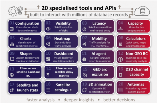
二十個精心設計的工具和 API 與數百萬個搜尋的資料庫記錄協同工作,從多個層面提供客觀、數據驅動的衛星星系效能評估。
數百萬次的動態計算透過直覺的介面進行處理,該介面配備可配置的篩選器、視覺化控制項和使用者自訂輸入功能。所有產出(數據、圖表、地圖、AI 報告和視覺化數據)均可輕鬆下載,以便進行進一步的分析和報告。
NCAT 6.3 的新增功能
- 資料庫擴充。升級到 163 個預先配置衛星群shell,包括最近提交的 Amazon Leo D2D、Eutelsat Next 和 Orbital Compute(用於 AI 推理的 ODC)。
- 改進了天地分析。增強的 3D 視覺化和動畫功能現在可以更精確地計算地面網路與空間資產(包括互聯的地球觀測 (EO) 和人工智慧 (AI) 衛星叢集)之間的連通性指標。帶有時間戳記的結果可以匯出為可下載的資料集,供下游工作流程使用。
主要特點
- 我們透過精確編碼的演算法提供可靠的結果,這些演算法能夠進行基於事實的分析、視覺化和 API 回應。
- 一個全面且定期更新的資料庫,以保持模擬結果的最新狀態。
- 每日:在軌衛星數量和軌道觀測資料每日自動更新。
- 每週:衛星目錄每週日自動更新。
- 每月:衛星和發射統計數據每月自動更新。
- 每季:核心軟體和資料庫增強功能按季度實施。
- 點擊式操作。使用者只需點擊幾下即可輕鬆操作互動式地圖和控制項(圖層、篩選器、設定),並執行動態計算和視覺化。
- 多軌、多頻段分析。使用者可以設定涵蓋一個或多個系統軌道殼層的模擬,從而能夠對不同頻段的數千顆衛星進行並行計算。
- 動態動畫視覺化功能使用戶能夠即時查看關鍵條件的趨勢,例如衛星位置、覆蓋範圍、可見衛星、天線波束角度、鏈路延遲波動以及供需動態。
- 時空控制。該平台支援全球、區域或局部尺度的即時和加速延時分析。模擬速度最高可提升 300 倍,使用戶能夠在約 5 分鐘內分析一整天的衛星群性能。
- 六邊形地面網格。 NCAT採用動態六邊形網格,精度可達國家級,並可配置至城市級解析度。 「形狀」工具允許使用者在資料庫預先載入的國家和地區之外,定義自己的地理區域。
- 並行 IP 吞吐量計算。 NCAT 對所有使用者波束和閘道波束執行平行鏈路預算吞吐量分析,同時考慮使用者終端和閘道之間的視距角組合。
- 靈活的需求模型。使用者可以從預先定義的需求標準中進行選擇,也可以定義自訂參數(例如使用者終端分佈、排除區域和頻寬需求的功能因素),以根據特定用例自訂模擬。
- 需求驅動型供應。使用者可以根據可選的公平性標準模擬可移動梁容量的動態重新配置,從而使可行的供應能夠最佳地匹配不斷變化的需求條件。
- 移動出行工具。 NCAT 透過使用者自訂的行程安排,支援各種行動行程應用(例如機上 Wi-Fi、鐵路、航運、聯網汽車)。它還整合了商業航班數據,以評估機上互聯 (IFC) 的供需情況。
- 統計數據。用戶可以存取和處理全面的目錄數據和衛星發射統計數據,並使用可配置的過濾器搜尋迄今為止發射的所有未分類衛星的數據。
- 人工智慧驅動的報告產生。此人工智慧代理工具利用自然語言與NCAT的內部工具和資料集無縫整合,能夠實現查詢回應、專家報告生成以及對模擬結果的快速解讀。
- 分析結果可供下載。所有圖表、地圖、報告和資訊圖表均可下載,格式為 PDF 或 PNG。輸出資料以表格形式CSV 格式提供,方便外部分析。數據包括表格、圖表數據、基準指標、帶有時間戳記的樣本、包含供需數據的地面網格、評估摘要、飛行路線、視線統計數據等等。
- 擴充性。 NCAT 可透過 RESTful API 進行擴展,從而可整合到內部工作流程和第三方系統中。
- 目的
- NCAT 主要專注於衛星通訊(satcom),但也具備評估地球觀測(EO)和全球導航衛星系統(GNSS)的能力。
- 工具
- 20 個可設定工具和 API,用於分析和評估衛星星系。
- 衛星群殼
- 包含超過 160 個目前正在運行、計劃中或已提交批准的衛星群外殼(用戶可編輯和可擴展)。
- 閘道
- 已調查的 400 多個閘道器位置(使用者可編輯和展開)
- 地理區域
- 包含超過 280 個國家、地區和區域(使用者可編輯和擴展)。
常問問題
- 我們如何從覆蓋範圍、容量、波束和衛星等方面比較當前和未來的非地球同步軌道(GEO)架構?
- 波束和衛星特定的前向和返回鏈路容量(頻寬、頻寬、IP吞吐量)是多少?
- 每個國家或地區,一個衛星群最多可以同時支援多少使用者?
- 如何計算每秒每兆位元可用容量的資本成本?
- 太空船的製造和發射成本在多大程度上影響商業案例?
- 在服務不足的地區,衛星通訊衛星群何時才能超越光纖通訊?
- 回程傳輸資本支出(CAPEX)和營運費用(OPEX)對商業案例有何影響?
- 基於可設定的服務方案,如何評估頻寬供需情況?此外,哪些區域最容易出現壅塞?
- 在每個位置的視野範圍內,衛星的最大數量、平均數量和最小數量分別是多少?
- 考慮到存取點 (POP)、星間光鏈路 (OISL) 和鏈路中繼,光纖的延遲與 LEO 系統的延遲相比如何?
- 非地球同步軌道(GEO)系統可獲得哪些監管豁免以避免干擾地球同步軌道(GEO)系統?
此工具箱的目標用戶
對於任何旨在運作、了解、競爭、合作或投資非地球同步軌道空間經濟的組織而言,NCAT 都是不可或缺的工具。
- 衛星營運商(地球同步軌道衛星、非地球同步軌道衛星、固定衛星服務、行動衛星服務/分散式衛星)
- 太空船製造商和零件供應商
- 地面/無線網路營運商(電信營運商、行動網路營運商、網際網路服務供應商、鐵塔營運商、IP傳輸供應商、雲端服務供應商)
- 地面系統供應商(終端、天線、集線器/數據機、SD-WAN)
- 傳送運營商、衛星服務供應商、整合商
- 主要非GEO容量用戶(政府、國防相關企業、航空公司、能源公司等)
- 產業協會、研究機構和研究設施
- 一家IT公司正在開發虛擬化衛星星系。
- 監管機構、航太機構、頻寬研究公司
- 金融機構及投資公司
NCAT 使用範例(一個範例)
企業類型和產業
- 衛星營運商
- 首席策略長(CSO)辦公室
優先領域和情況
- 與競爭對手進行標竿分析與策略定位
- 多軌道衛星營運商需要改進與低地球軌道衛星群的競爭策略。
NCAT 的支持詳情
- NCAT能夠進行快速、數據驅動的模擬,從而在區域層面上比較和評估服務提供者(在延遲、吞吐量和覆蓋範圍方面)與非GEO競爭對手的效能。這些洞察有助於制定關鍵策略計劃,並在快速變化的市場中應對競爭。
企業類型和產業
- 電信營運商和行動網路營運商
- 業務拓展部
優先領域和情況
- 直接到設備 (D2D) 和本地回程傳輸的合作夥伴關係
- 電信業者需要評估D2D和FSS衛星寬頻衛星群帶來的機會和風險。
NCAT 的支持詳情
- NCAT能夠精確測量當前和未來D2D衛星星系的通道和波束容量、覆蓋永續性以及技術可行性。這有助於制定有關夥伴關係關係、投資和競爭定位的策略決策。
相關人員類型和部門
- 國內監理機構
- 射頻頻譜管理組織
優先領域和情況
- 對國家主導的衛星星系進行評估
- 某個國家的通訊監管機構正在考慮一項關於主權非地球同步衛星星系的提議架構。
NCAT 的支持詳情
- NCAT透過迭代設計分析,協助定義滿足國家政府、國防和寬頻目標的「最小可行架構」。這使得可以透過商業性和技術評估來評估可行性、永續性和政策影響。
相關人員和部門
- 太空船製造商
- 業務拓展與工程
優先領域和情況
- 衛星星系和衛星設計的合作
- 製造商需要跨部門和外部合作才能獲得大規模的D2D合約。
NCAT可以提供哪些支援?
- NCAT利用多種工具,支援對各種衛星群設計及其商業性影響進行協同模擬。其視覺化、分析功能和共用數據,能夠促進高效的內部協作和引人注目的外部溝通,從而直接助力合約的獲取。
相關人員和部門
- 地面設備製造商
- 財務總監辦公室
優先領域和情況
- 市場拓展潛力及商業案例
- 財務長需要根據全球和國家衛星需求,了解地面系統可以在哪些地方、以何種方式以及以何種數量銷售。
NCAT可以提供哪些支援?
- NCAT 提供關於衛星星系覆蓋範圍、容量和市場需求的詳細資訊。這些數據可直接用於新產品線和目標客戶的收入預測、生產規劃和投資回報率分析,從而將技術能力與清晰的財務預測聯繫起來。
相關人員類型和部門
- 國防相關企業
- 工程與專案管理部
優先領域和情況
- 產能分析與客戶支持
- 承包商需要評估多軌道架構,以滿足國防環境中的韌性和運作需求。
NCAT可以提供哪些支援?
- NCAT 提供關於衛星可見性、覆蓋連續性、鏈路延遲、區域系統容量和整體網路容錯能力的詳細資訊。這有助於關鍵任務規劃以及與國防利害關係人的有效溝通。
目標中包含的衛星系統範例
- Amazon Leo
- AST SpaceMobile
- Blue Origin's TeraWave
- E-Space
- Eutelsat's OneWeb
- G60 Thousand Sails (Qianfan)
- Globalstar
- Iridium
- Kepler
- Lynk Global
- Mangata Networks
- Rivada Space
- SES mPOWER & O3b
- SpaceX 星鏈(寬頻和 D2D/D2C)
- Telesat Lightspeed
The Non-GEO Constellations Analysis Toolkit (NCAT) is the industry-leading platform for objective, data-driven, multi-level assessments of low-Earth-orbit (LEO) and medium-Earth-orbit (MEO) satellite constellations.
NCAT is delivered as a user-friendly web application that provides strategists, business leaders and technical professionals with reliable, data-driven and integrable competitive intelligence on the technical and commercial capabilities and impacts of non-geostationary (non-GEO) systems. The platform also offers complementary extensions, including application programming interfaces (APIs) and the Telecom Network Analysis Tool (TNAT), which provide dedicated datasets and analytical models for evaluating terrestrial and wireless networks.
NCAT bridges the technical–business gap by combining diverse datasets, advanced analytics, AI and interactive visualisations to seamlessly explore:
- coverage and visibility persistence
- bandwidth supply and demand
- market addressability and opportunity
- business-case sensitivities
- satellite and launch statistics.
The platform allows users to easily calculate key performance metrics and to benchmark the competitiveness of satellite constellations, both against each other and relative to terrestrial networks, all without requiring deep technical expertise.
Toolkit coverage
20 rigorously engineered tools and APIs interact with millions of queryable database records to deliver objective, data-driven assessments of constellation performance across multiple levels.
Millions of dynamic calculations are processed via an intuitive interface with configurable filters, visualisation controls and user-defined inputs. All outputs (data, charts, maps, AI reports and visualisations) are easily downloadable for further analysis or reporting.
NEW with NCAT 6.3
- Expanded database. Upgraded to 163 preconfigured constellation shells, including the recently filed Amazon Leo D2D, Eutelsat Next and Orbital Compute (ODCs for AI inference)
- Improved space – ground analysis. Enhanced 3D visualisation and animation enable more precise calculation of connectivity metrics between ground networks and space assets, including clusters of interconnected Earth observation (EO) and AI satellites. Timestamped results can be exported as downloadable datasets for downstream workflows.
Features included
- Precisely coded algorithms that drive factual analytics, visualisations and API responses for trustworthy results.
- A comprehensive, regularly updated database to ensure up-to-date simulations.
- Daily: in-orbit satellite counts and orbital observations are updated automatically every day.
- Weekly: the satellite catalogue is refreshed automatically each Sunday.
- Monthly: satellite and launch statistics are updated automatically every month.
- Quarterly: core software and database enhancements are made every quarter.
- Point-and-click interactivity. Users can easily navigate interactive maps and controls (layers, filters and settings) to drive dynamic calculations and visualisations with a few clicks.
- Multi-orbit, multi-band analysis. Users can configure simulations across orbital shells from one or multiple systems, thus enabling concurrent calculations for thousands of satellites across different frequency bands.
- Dynamic, animated visualisations. Users can view the real-time propagation of key conditions, including satellite positions, coverage footprints, visible satellites, antenna look angles, link latency variations and supply–demand dynamics.
- Space-time controls. The platform supports both real-time and accelerated time-lapse analysis at global, regional or local scales. Simulations can be sped up by up to 300×, thus enabling users to analyse a full day of constellation performance in around 5 minutes.
- Hexagonal ground grid. NCAT employs a dynamic hexagonal grid with country-level precision that is configurable down to city-scale resolution. The ‘Shapes’ tool enables users to define custom geographical areas beyond the countries and regions preloaded in the database.
- Concurrent IP throughput computations. NCAT performs concurrent link-budget throughput analysis across all user and gateway beams, accounting for combinations of user-terminal and gateway look angles.
- Flexible demand models. Users can choose from pre-set demand criteria or can define custom parameters (including user terminal distribution, exclusion zones and functional drivers of bandwidth demand) to tailor simulations to specific use cases.
- Demand-driven supply. Users can simulate dynamic reconfigurations of steerable beam capacity based on selectable fairness criteria to optimally match feasible supply with changing demand conditions.
- Mobility tool. NCAT supports a wide range of mobility applications (in-flight Wi-Fi, rail, maritime and connected vehicles) through user-defined schedules. It also integrates commercial flight data to assess in-flight connectivity (IFC) supply and demand.
- Statistics. Users can access and process comprehensive catalogued data and satellite launch statistics, with configurable filters to explore data for all unclassified satellites ever launched.
- AI-powered report generation. The AI agent tool uses natural language to interact seamlessly with internal NCAT tools and datasets, enabling it to answer queries, generate professional reports and interpret simulation results quickly.
- Downloadable insights. All charts, maps, reports and infographics are downloadable (in PDF or PNG format). Output data is available in tabular CSV format for external analysis, including tables, chart data, benchmark metrics, time-stamped samples, terrestrial grids with supply and demand data, assessment summaries, flight routes, look angle statistics and more.
- Extensible. NCAT is extensible via RESTful APIs for integration into internal workflows and third-party systems.
- Applications
- NCAT is primarily focused on satellite communications (satcom) but includes features to assess Earth observation (EO) and global navigation satellite systems (GNSS).
- Tools
- 20 configurable tools and APIs to analyse and benchmark constellations
- Constellation shells
- 160+ operational, planned and filed shells included (user editable and expandable)
- Gateways
- 400+ surveyed gateway locations (user editable and expandable)
- Geographical regions
- 280+ countries, territories and regions included (user editable and expandable)
Questions answered
- How do current and future non-GEO architectures compare in terms of coverage, capacity, beam and satellites?
- What is the forward and return link capacity (spectrum, bandwidth and IP throughput) per beam and satellite?
- How many users can constellations support simultaneously, by country or territory?
- How is the capital cost per usable megabits per second determined?
- What is the business-case sensitivity to spacecraft manufacturing and launch costs?
- When will satellite communications constellations outperform fibre-optics in underserved communities?
- How does backhaul capex and opex affect the business case?
- How can bandwidth supply and demand be assessed based on configurable service plans, and where are the congestion hotspots?
- What is the maximum, average and minimum number of satellites in line of sight at each location?
- How does fibre latency compare with that of LEO systems, factoring in points of presence (POPs), optical inter-satellite links (OISLs) and link relays?
- What are the regulatory exclusion angles for non-GEO systems to avoid GEO interference?
Who should use this toolbox
NCAT is essential for any organisation that is aiming to operate in, understand, compete within, collaborate across or invest in the non-GEO space economy.
- Satellite operators (GEO, non-GEO, FSS and MSS/D2D)
- Spacecraft manufacturers and component vendors
- Terrestrial/wireless network operators (telecoms operators, MNOs, ISPs, towercos, IP transit providers and cloud services providers)
- Ground system vendors (terminals, antennas, hub/modems and SD-WAN)
- Teleport operators, satellite service providers and integrators
- Major non-GEO capacity users (such as governments, defence players, airlines and energy companies)
- Industry associations, research labs and institutions
- IT companies developing virtualised constellation architectures
- Regulators, space agencies and spectrum research firms
- Financial institutions and investment firms
Sample NCAT use cases
Player type and department
- Satellite operator
- Chief strategy officer (CSO)'s office
Focus area and situation
- Competitive benchmarking and strategic positioning
- A multi-orbit satellite operator must refine its competitive response to LEO mega-constellations.
How NCAT can help
- NCAT enables rapid, data-driven simulations to benchmark the operator's performance (in terms of latency, throughput and coverage) against other non-GEO competitors on a per-territory basis. These insights support high-stakes strategic planning and informed competitive responses in a fast-moving market.
Player type and department
- Telecoms operator and MNO
- Business development office
Focus area and situation
- Direct-to-device (D2D) and rural backhaul partnerships
- The operator needs to assess the opportunities and risks posed by D2D and FSS satellite broadband constellations.
How NCAT can help
- NCAT precisely measures the channel and beam capacity, coverage persistence and technical viability of current and upcoming D2D constellations. This can be used to inform strategic decisions on partnerships, investment and competitive positioning.
Player type and department
- National regulator
- Radio frequency spectrum management office
Focus area and situation
- Sovereign constellation assessment
- A national telecoms regulator is exploring architectural options for a sovereign non-GEO constellation.
How NCAT can help
- NCAT supports iterative design analysis to define a minimum viable architecture that meets national government, defence and broadband objectives. It enables both commercial and technical assessments to evaluate feasibility, sustainability and policy implications.
Player type and department
- Spacecraft manufacturer
- Business development and engineering departments
Focus area and situation
- Constellation and satellite design collaboration
- The manufacturer needs cross-departmental and external collaboration to secure a major D2D deal.
How NCAT can help
- NCAT enables the collaborative, multi-tool simulation of various constellation designs and their commercial impact. Its visuals, analytics and shareable data support effective internal coordination and compelling external communication, thus contributing directly to winning the contract.
Player type and department
- Ground equipment manufacturer
- Chief financial officer (CFO)'s office
Focus area and situation
- Market addressability and business case
- The CFO needs to understand where, how and how many, ground systems can be sold based on global and country-level satellite demand.
How NCAT can help
- NCAT provides detailed insights into constellation coverage, capacity and market demand. This data feeds directly into revenue forecasts, manufacturing planning and ROI analysis for new product lines and target clients, thus translating technical capabilities into clear financial projections.
Player type and department
- Defence contractor
- Engineering and programme management offices
Focus area and situation
- Capacity analysis and client-facing support
- The contractor needs to assess multi-orbit architectures to meet resiliency and operational needs in defence environments.
How NCAT can help
- NCAT delivers detailed insights into satellite visibility, coverage continuity, link latency, territorial system capacity and overall network resilience. This supports mission-critical planning and effective communication with defence stakeholders.
Examples of satellite systems included
- Amazon Leo
- AST SpaceMobile
- Blue Origin's TeraWave
- E-Space
- Eutelsat's OneWeb
- G60 Thousand Sails (Qianfan)
- Globalstar
- Iridium
- Kepler
- Lynk Global
- Mangata Networks
- Rivada Space
- SES mPOWER & O3b
- SpaceX Starlink (broadband and D2D/D2C)
- Telesat Lightspeed

 低地球衛星星系市場報告:趨勢、預測和競爭分析(至2035年)
 2026年全球衛星星系市場報告
 衛星衛星群市場機會、成長要素、產業趨勢分析及2026-2035年預測2026年低地球衛星星系全球市場報告
 太空發射與近地軌道衛星通訊:SpaceX 鞏固其市場主導地位