


 |
市場調查報告書
商品編碼
2124047
地理資訊系統:市場佔有率分析、產業趨勢與統計、成長預測(2026-2031)Geographic Information System - Market Share Analysis, Industry Trends & Statistics, Growth Forecasts (2026 - 2031) |
||||||

※ 本網頁內容可能與最新版本有所差異。詳細情況請與我們聯繫。
據 Mordor Intelligence 稱,地理資訊系統 (GIS) 市場在 2025 年的價值為 145.6 億美元,預計到 2031 年將達到 318 億美元,而 2026 年為 165.8 億美元,預測期(2026-2031 年)的複合年成長率為 13.94%。
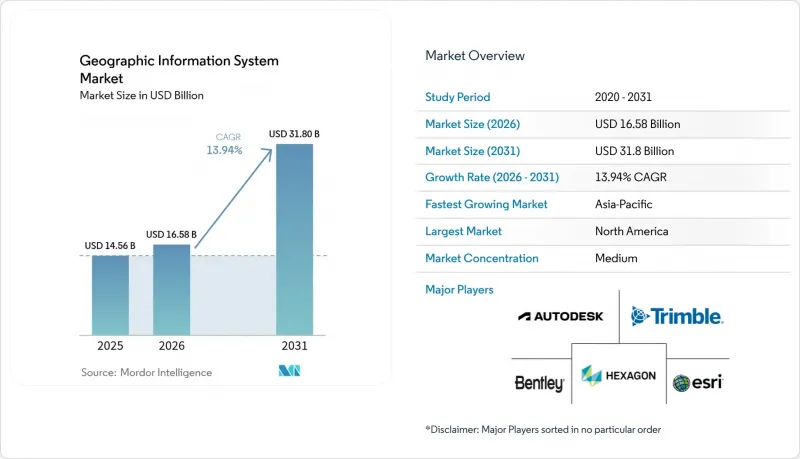
本報告按組件(硬體、軟體、服務)、功能(測繪、測量等)、部署模式(本地部署、雲端部署)、最終用戶產業(農業、公共產業、採礦、建築等)和地區進行細分。市場預測以美元計價。
全球地理資訊系統(GIS)市場趨勢與洞察
即時地理空間基礎設施對於智慧城市的廣泛部署至關重要。
地方政府機構正在將地理資訊系統 (GIS) 市場平台與 5G、物聯網和邊緣運算相結合,以簡化城市服務。新加坡的「開放數位平台」透過串流地理空間資料同步區域供冷、廢棄物和能源供應,從而提高事件回應速度和基礎設施運轉率。在洛杉磯,即時儀錶板用於規劃緊急應變團隊的路線,尖峰時段可記錄 350 萬次態勢圖視圖。隨著地方政府將數位孿生納入累計,提供可擴展 3D 視覺化、感測器 API 和網路安全增強功能的供應商在公共部門 IT 支出中佔據的佔有率越來越大。
雲端原生GIS可降低整體擁有成本並加速企業整合。
貝爾加拿大公司透過遷移到雲端原生地理空間資料平台,降低了 40% 至 60% 的基礎設施支出。這顯示容器化微服務和託管升級如何能夠縮短引進週期。基於 Kubernetes 的 ArcGIS Enterprise 和類似解決方案將 GIS 作業與 DevOps 管線整合,能夠在災難期間實現動態擴展,而不會造成採購延誤。雲端資料倉儲中的下推分析消除了 ETL 瓶頸,並將地理資訊系統 (GIS) 市場的目標受眾擴展到傳統測繪團隊之外。
傳統IT系統與OT和SCADA系統整合的複雜性
公共產業在將現代地理資訊系統 (GIS) 與沿用數十年的監控與資料收集 (SCADA) 系統整合時,面臨著資料模型不一致、協定缺陷以及新興網路威脅等問題。例如,Liberty Utilities 公司由於需要進行迭代測試和中介軟體開發,其遷移計畫延長了 18 個月。這些延誤導致支出轉向專業服務,從而減緩了地理資訊系統市場的軟體遷移進程。
細分市場分析
2026年,地理資訊系統 (GIS) 市場的業務收益大幅成長,複合年成長率 (CAGR) 達到15.45%,主要得益於企業將雲端遷移、人工智慧模式調優和生命週期支援等服務外包。託管服務包現在涵蓋資料品質審核、安全性修補程式和全天候監控,支出也從資本支出轉向營運預算。 2025年,軟體收入仍將佔總營收的53.60%,其中ArcGIS、Hexagon NetWorks和Trimble Cityworks產品組合為核心。持續的更新週期使Esri能夠將約28%的年收入再投資於研發,從而保持較高的功能新增速度,同時其開放的API框架也積極支持第三方擴展。硬體對於全球導航衛星系統 (GNSS)接收器、雷射雷達掃描器和抗震平板電腦仍然至關重要,但隨著越來越多的功能轉移到軟體層,其利潤率正受到擠壓。因此,儘管感測器數量增加,但與純硬體出貨量相關的地理資訊系統 (GIS) 市場規模成長速度卻較為緩慢。
產業負責人更傾向於選擇能夠提供以結果為導向的服務等級協定 (SLA) 的供應商。例如,Hexagon 決定在 2025 年出售非核心資產,從而釋放了資金,用於擴展其基於訂閱的支援服務。培訓機構、DevOps 工具鏈和認證合作夥伴網路如今已成為重要的選擇標準,這表明地理資訊系統市場正在從關注許可證數量轉向關注客戶成功指標。
到2025年,測繪領域將佔據34.10%的市場佔有率,為所有下游工作流程提供空間背景資訊。然而,在邊緣推理、基礎模型和資料湖架構的推動下,分析子領域的成長最為迅猛,複合年成長率高達15.70%。企業正在將預測性地理圍欄技術整合到其ERP系統中,政府機構則利用多光譜頻譜來模擬城市熱島效應。測量領域也穩步發展,無人機攝影測量技術的引入將獲取地形數據所需的時間從一周縮短至一天。
隨著電動車 (EV) 路線最佳化和冷鏈監控的興起,車載資訊服務產業正在蓬勃發展,並整合了電動車專屬的續航里程計算功能。定位服務透過高度個人化的零售應用程式蓬勃發展,這些應用程式可以觸發店內促銷活動,但與智慧型手機原生作業系統 API 的競爭正在限制供應商的利潤率。整體而言,地理資訊系統 (GIS) 市場正基於全面的資料架構原則調整其功能藍圖,將資料擷取、編目和人工智慧管道整合到單一的管治結構下。
區域分析
預計到2025年,北美地區的支出將佔全球的37.80%,這主要得益於成熟的雲端基礎設施、雄厚的研發資金以及政府的強制性規定,例如美國《地理空間資料法案》(該法案旨在規範互通性和元元資料)。聯邦計畫正在為野火建模、寬頻缺口測繪以及確保關鍵基礎設施的韌性等項目爭取多年預算。像Trimble這樣的公司每年在創新方面投入超過6.6億美元,其獲得的專利進一步鞏固了該地區的技術優勢。然而,不斷飆升的雲端儲存成本對Petabyte級影像分析構成了成本挑戰,促使各方就採用在地化的主權雲端方案展開談判。
亞太地區預計將實現15.95%的最高複合年成長率,主要得益於特大城市的現代化和基礎設施獎勵策略。新加坡正在擴展3D地下測繪以緩解空間限制,而印度的「數位孿生計畫」則將物流走廊與統一的包裹級地籍資訊連接起來。沙烏地阿拉伯與NAVER投資10億美元的數位孿生合資計畫凸顯了海灣國家在智慧城市建設方面引領潮流的雄心。該地區面臨的挑戰包括資料居住規則分散和出口限制不一致,但透過國內衛星發射和主權雲區域的建設,這種依賴性正在降低。
在INSPIRE指令的支持下,歐洲的成長勢頭強勁,該指令旨在促進高價值資料集的民主化。開放取用正在推動氣候風險評估和可再生能源位置分析領域新創企業的蓬勃發展。 GDPR正在影響架構設計,並促進隱私增強型運算和本地處理的發展。儘管南美、中東和非洲的市場規模總合相對較小,但在礦產探勘、精密農業和基礎設施安全等領域,GIS的應用正在加速成長。在這些市場中,雲端原生GIS通常從一開始就被採用,繞過了傳統系統,從而透過待開發區需求擴大了地理資訊系統(GIS)的市場規模。
其他好處:
- Excel格式的市場預測(ME)表
- 3個月的分析師支持
目錄
第1章:引言
- 研究假設和市場定義
- 調查範圍
第2章:調查方法
第3章執行摘要
第4章 市場狀況
- 市場概覽
- 市場促進因素
- 智慧城市的廣泛部署需要即時地理空間基礎架構。
- 雲端原生GIS可降低整體擁有成本,並加速企業內部整合。
- 我們以行動端為先的現場數據採集平台正在擴大我們的目標用戶群。
- 人工智慧驅動的衛星圖像自動分類可加快分析速度。
- 精度低於 30 公分的商用微型衛星衛星群正在開闢新的高精度應用場景。
- 各國強制推行的開放資料計畫(例如歐盟的 INSPIRE 2.0 和美國的 GDA)正在推動開放資料的普及。
- 市場限制因素
- 傳統IT系統與OT和SCADA系統整合的複雜性
- 群眾外包層中資料品質和資料處理歷程方面持續存在的挑戰
- Petabyte級影像存檔的雲端出口成本飆升
- 加強對高解析度地理空間資料的出口限制
- 價值鏈分析
- 監理情勢
- 技術展望
- 產業吸引力—五力分析
- 供應商的議價能力
- 買方的議價能力
- 新進入者的威脅
- 替代品的威脅
- 競爭公司之間的競爭
- 宏觀經濟因素對市場的影響
第5章 市場規模與成長預測
- 按組件
- 硬體
- 軟體
- 服務
- 按功能
- 地圖
- 測量
- 車載資訊系統和導航
- 定位服務
- 地理空間資料的管理與分析
- 部署模式
- 現場
- 雲
- 按最終用戶行業分類
- 農業
- 公用事業
- 礦業
- 建造
- 運輸/物流
- 石油和天然氣
- 政府/國防
- 電訊
- 其他終端用戶產業
- 按地區
- 北美洲
- 美國
- 加拿大
- 墨西哥
- 南美洲
- 巴西
- 阿根廷
- 智利
- 其他南美國家
- 歐洲
- 德國
- 英國
- 法國
- 義大利
- 西班牙
- 其他歐洲國家
- 亞太地區
- 中國
- 印度
- 日本
- 韓國
- 馬來西亞
- 新加坡
- 澳洲
- 其他亞太國家
- 中東和非洲
- 中東
- 阿拉伯聯合大公國
- 沙烏地阿拉伯
- 土耳其
- 其他中東國家
- 非洲
- 南非
- 奈及利亞
- 其他非洲國家
- 中東
- 北美洲
第6章 競爭情勢
- 市場集中度
- 策略趨勢
- 市佔率分析
- 公司簡介
- Environmental Systems Research Institute, Inc.(Esri)
- Hexagon AB
- Trimble Inc.
- Autodesk, Inc.
- Bentley Systems, Incorporated
- Topcon Positioning Systems, Inc.
- Pitney Bowes, Inc.(Precisely)
- Caliper Corporation
- Mapbox, Inc.
- Maxar Technologies Inc.
- Fugro NV
- SuperMap Software Co., Ltd.
- CARTO(CartoDB Inc.)
- Blue Marble Geographics, LLC
- GIS Cloud Ltd.
- TomTom NV
- Seequent Limited
- Spatialworks, Inc.
- Geosoft Inc.
- Woolpert, Inc.
- NV5 Geospatial Solutions, Inc.
- BlackSky Technology Inc.
第7章 市場機會與未來展望
According to Mordor Intelligence, the geographic information system market size was valued at USD 14.56 billion in 2025 and estimated to grow from USD 16.58 billion in 2026 to reach USD 31.8 billion by 2031, at a CAGR of 13.94% during the forecast period (2026-2031).
This report is Segmented by Component (Hardware, Software, and Services), Function (Mapping, Surveying, and More), Deployment Mode (On-Premise and Cloud), End-User Industry (Agriculture, Utilities, Mining, Construction, and More), and Geography. The Market Forecasts are Provided in Terms of Value (USD).
Global Geographic Information System Market Trends and Insights
Widespread Smart-City Roll-Outs Require Real-Time Geospatial Infrastructure
City agencies are integrating the Geographic information system market platforms with 5G, IoT, and edge compute to orchestrate urban services. Singapore's Open Digital Platform synchronizes district cooling, waste, and energy through streaming geospatial feeds, improving incident response and infrastructure uptime. Los Angeles uses real-time dashboards to route emergency crews, drawing 3.5 million situational-awareness map views during peak events. As municipalities budget for digital twins, vendors that deliver scalable 3D visualization, sensor APIs, and cybersecurity hardening capture a growing portion of public-sector IT spend.
Cloud-Native GIS Lowers TCO and Speeds Enterprise Integration
Bell Canada saved 40-60% in infrastructure outlay by shifting to a cloud-native geospatial data platform, illustrating how containerized micro-services and managed upgrades shorten deployment cycles. ArcGIS Enterprise on Kubernetes and similar offerings align GIS operations with DevOps pipelines, allowing dynamic scaling during disaster events without procurement delays. Push-down analytics in cloud data warehouses eliminate ETL bottlenecks, widening the Geographic information system market addressable base beyond traditional mapping teams.
Legacy IT Integration Complexity with OT and SCADA Systems
Utilities merging modern GIS with decades-old SCADA confront data-model mismatches, protocol gaps, and new cyber-threat surfaces. Liberty Utilities extended its migration timeline by 18 months due to iterative testing and middleware development. These overruns shift spending toward professional services, slowing software conversions in the Geographic information system market.
Other drivers and restraints analyzed in the detailed report include:
- Mobile-First Field-Data-Collection Platforms Expand Addressable User Base
- AI-Powered Auto-Classification of Satellite Imagery Accelerates Analytics
- Persistent Data-Quality / Lineage Gaps in Crowdsourced Layers
For complete list of drivers and restraints, kindly check the Table Of Contents.
Segment Analysis
Services revenue in the Geographic information system market rose sharply in 2026, advancing at a 15.45% CAGR as enterprises outsourced cloud migration, AI model tuning, and lifecycle support. Managed-service bundles now cover data-quality audits, security patching, and 24/7 monitoring, shifting spending from capital to operating budgets. Software still accounts for 53.60% of 2025 sales, anchored by the ArcGIS, Hexagon NetWorks, and Trimble Cityworks portfolios. Their continuous update cadence, Esri reinvests roughly 28% of annual turnover into R&D, keeping feature velocity high, while open-API frameworks welcome third-party extensions. Hardware remains essential for GNSS receivers, lidar scanners, and rugged tablets, yet margins compress as more functions migrate into the software layer. The geographic information system market size tied to pure hardware shipments therefore grows more slowly, even as sensor count climbs.
Industry buyers favor vendors that can deliver outcome-oriented service-level agreements; for example, Hexagon's 2025 decision to divest non-core assets freed capital to bolster subscription support offerings. Training academies, DevOps toolchains, and certified partner networks now form critical selection criteria, signaling a pivot from license counts to customer success metrics across the Geographic information system market.
Mapping held a 34.10% share in 2025, furnishing the spatial context for every downstream workflow. Yet the analytics sub-segment is expanding fastest at 15.70% CAGR, powered by edge inference, foundation models, and data-lakehouse architectures. Enterprises embed predictive geofencing into ERPs, while authorities model urban heat islands through multi-spectral stacks. Surveying remains steady, reinvented through drone photogrammetry that compresses week-long terrain captures into same-day deliverables.
Telematics gains from electric-vehicle routing and cold-chain monitoring, integrating EV-specific range calculations. Location-based services flourish via hyper-personalized retail apps that trigger in-store promotions, though competition from native smartphone OS APIs keeps vendor margins in check. Overall, the Geographic information system market aligns functional roadmaps around holistic data-fabric principles, merging ingestion, cataloging, and AI pipelines under a single governance umbrella.
Complete Report Scope:
- By Component
- Hardware
- Software
- Services
- By Function
- Mapping
- Surveying
- Telematics and Navigation
- Location-based Services
- Geospatial Data Management and Analysis
- By Deployment Mode
- On-premise
- Cloud
- By End-user Industry
- Agriculture
- Utilities
- Mining
- Construction
- Transportation and Logistics
- Oil and Gas
- Government and Defence
- Telecommunications
- Other End-user Industries
- By Geography
- North America
- United States
- Canada
- Mexico
- South America
- Brazil
- Argentina
- Chile
- Rest of South America
- Europe
- Germany
- United Kingdom
- France
- Italy
- Spain
- Rest of Europe
- Asia-Pacific
- China
- India
- Japan
- South Korea
- Malaysia
- Singapore
- Australia
- Rest of Asia-Pacific
- Middle East and Africa
- Middle East
- United Arab Emirates
- Saudi Arabia
- Turkey
- Rest of Middle East
- Africa
- South Africa
- Nigeria
- Rest of Africa
- Middle East
- North America
Geography Analysis
North America preserved 37.80% of 2025 spending, thanks to mature cloud infrastructure, robust R&D funding, and agency mandates like the U.S. Geospatial Data Act that standardize interoperability and metadata. Federal programs secure multi-year budgets for wildfire modeling, broadband equity mapping, and critical-infrastructure resilience. Enterprises such as Trimble invest more than USD 660 million annually in innovation, generating patents that reinforce the region's technological edge. Yet rising cloud-de-storage fees pose cost challenges for petabyte-class imagery analytics, motivating negotiations for localized sovereign clouds.
Asia-Pacific is on track for the highest 15.95% regional CAGR, fuelled by megacity modernization and infrastructure stimulus. Singapore scales 3D underground mapping to mitigate space constraints, while India's Digital Twin Mission links logistics corridors with unified parcel-level cadasters. Saudi Arabia's USD 1 billion digital-twin collaboration with Naver underscores Gulf ambitions for smart-city leadership. Regional hurdles include fragmented data-residency rules and varying export controls, yet domestic satellite launches and sovereign cloud zones are mitigating dependencies.
Europe's growth remains steady, anchored by the INSPIRE directive that democratizes high-value datasets. Open access spawns start-ups specializing in climate-risk scoring and renewable-siting analytics. GDPR influences architecture design, spurring privacy-enhancing computation and in-region processing. South America, the Middle East, and Africa together represent a smaller base but display accelerated adoption in mineral exploration, precision agriculture, and infrastructure security. These markets often leapfrog legacy systems, adopting cloud-native GIS from inception, thereby enlarging the Geographic information system market size through greenfield demand.
- Environmental Systems Research Institute, Inc. (Esri)
- Hexagon AB
- Trimble Inc.
- Autodesk, Inc.
- Bentley Systems, Incorporated
- Topcon Positioning Systems, Inc.
- Pitney Bowes, Inc. (Precisely)
- Caliper Corporation
- Mapbox, Inc.
- Maxar Technologies Inc.
- Fugro N.V.
- SuperMap Software Co., Ltd.
- CARTO (CartoDB Inc.)
- Blue Marble Geographics, LLC
- GIS Cloud Ltd.
- TomTom N.V.
- Seequent Limited
- Spatialworks, Inc.
- Geosoft Inc.
- Woolpert, Inc.
- NV5 Geospatial Solutions, Inc.
- BlackSky Technology Inc.
Additional Benefits:
- The market estimate (ME) sheet in Excel format
- 3 months of analyst support
TABLE OF CONTENTS
1 INTRODUCTION
- 1.1 Study Assumptions and Market Definition
- 1.2 Scope of the Study
2 RESEARCH METHODOLOGY
3 EXECUTIVE SUMMARY
4 MARKET LANDSCAPE
- 4.1 Market Overview
- 4.2 Market Drivers
- 4.2.1 Widespread smart-city roll-outs require real-time geospatial infrastructure
- 4.2.2 Cloud-native GIS lowers TCO and speeds enterprise integration
- 4.2.3 Mobile-first field-data-collection platforms expand addressable user base
- 4.2.4 AI-powered auto-classification of satellite imagery accelerates analytics
- 4.2.5 Sub-30 cm commercial microsatellite constellations unlock new precision use-cases
- 4.2.6 National open-data mandates (EU INSPIRE 2.0, US GDA, etc.) drive adoption
- 4.3 Market Restraints
- 4.3.1 Legacy IT integration complexity with OT and SCADA systems
- 4.3.2 Persistent data-quality/lineage gaps in crowdsourced layers
- 4.3.3 Rising cloud-egress fees for petabyte-scale imagery archives
- 4.3.4 Export-control tightening on high-resolution geospatial data
- 4.4 Value Chain Analysis
- 4.5 Regulatory Landscape
- 4.6 Technological Outlook
- 4.7 Industry Attractiveness - Porter's Five Forces Analysis
- 4.7.1 Bargaining Power of Suppliers
- 4.7.2 Bargaining Power of Buyers
- 4.7.3 Threat of New Entrants
- 4.7.4 Threat of Substitutes
- 4.7.5 Intensity of Competitive Rivalry
- 4.8 Impact of Macroeconomic Factors on the Market
5 MARKET SIZE AND GROWTH FORECASTS (VALUES)
- 5.1 By Component
- 5.1.1 Hardware
- 5.1.2 Software
- 5.1.3 Services
- 5.2 By Function
- 5.2.1 Mapping
- 5.2.2 Surveying
- 5.2.3 Telematics and Navigation
- 5.2.4 Location-based Services
- 5.2.5 Geospatial Data Management and Analysis
- 5.3 By Deployment Mode
- 5.3.1 On-premise
- 5.3.2 Cloud
- 5.4 By End-user Industry
- 5.4.1 Agriculture
- 5.4.2 Utilities
- 5.4.3 Mining
- 5.4.4 Construction
- 5.4.5 Transportation and Logistics
- 5.4.6 Oil and Gas
- 5.4.7 Government and Defence
- 5.4.8 Telecommunications
- 5.4.9 Other End-user Industries
- 5.5 By Geography
- 5.5.1 North America
- 5.5.1.1 United States
- 5.5.1.2 Canada
- 5.5.1.3 Mexico
- 5.5.2 South America
- 5.5.2.1 Brazil
- 5.5.2.2 Argentina
- 5.5.2.3 Chile
- 5.5.2.4 Rest of South America
- 5.5.3 Europe
- 5.5.3.1 Germany
- 5.5.3.2 United Kingdom
- 5.5.3.3 France
- 5.5.3.4 Italy
- 5.5.3.5 Spain
- 5.5.3.6 Rest of Europe
- 5.5.4 Asia-Pacific
- 5.5.4.1 China
- 5.5.4.2 India
- 5.5.4.3 Japan
- 5.5.4.4 South Korea
- 5.5.4.5 Malaysia
- 5.5.4.6 Singapore
- 5.5.4.7 Australia
- 5.5.4.8 Rest of Asia-Pacific
- 5.5.5 Middle East and Africa
- 5.5.5.1 Middle East
- 5.5.5.1.1 United Arab Emirates
- 5.5.5.1.2 Saudi Arabia
- 5.5.5.1.3 Turkey
- 5.5.5.1.4 Rest of Middle East
- 5.5.5.2 Africa
- 5.5.5.2.1 South Africa
- 5.5.5.2.2 Nigeria
- 5.5.5.2.3 Rest of Africa
- 5.5.5.1 Middle East
- 5.5.1 North America
6 COMPETITIVE LANDSCAPE
- 6.1 Market Concentration
- 6.2 Strategic Moves
- 6.3 Market Share Analysis
- 6.4 Company Profiles (includes Global level Overview, Market level overview, Core Segments, Financials as available, Strategic Information, Market Rank/Share for key companies, Products and Services, and Recent Developments)
- 6.4.1 Environmental Systems Research Institute, Inc. (Esri)
- 6.4.2 Hexagon AB
- 6.4.3 Trimble Inc.
- 6.4.4 Autodesk, Inc.
- 6.4.5 Bentley Systems, Incorporated
- 6.4.6 Topcon Positioning Systems, Inc.
- 6.4.7 Pitney Bowes, Inc. (Precisely)
- 6.4.8 Caliper Corporation
- 6.4.9 Mapbox, Inc.
- 6.4.10 Maxar Technologies Inc.
- 6.4.11 Fugro N.V.
- 6.4.12 SuperMap Software Co., Ltd.
- 6.4.13 CARTO (CartoDB Inc.)
- 6.4.14 Blue Marble Geographics, LLC
- 6.4.15 GIS Cloud Ltd.
- 6.4.16 TomTom N.V.
- 6.4.17 Seequent Limited
- 6.4.18 Spatialworks, Inc.
- 6.4.19 Geosoft Inc.
- 6.4.20 Woolpert, Inc.
- 6.4.21 NV5 Geospatial Solutions, Inc.
- 6.4.22 BlackSky Technology Inc.
7 MARKET OPPORTUNITIES AND FUTURE OUTLOOK
- 7.1 White-space and Unmet-Need Assessment

 雲端GIS市場:按元件、功能、部署類型、應用程式、最終用戶、國家和地區分類-全球產業分析、市場規模、市場佔有率及2026年至2033年預測
 2026-2030年全球地理資訊系統分析市場
 地理資訊系統(GIS)市場:按組件、技術類型、設備類型、功能、部署模式、最終用戶產業和應用分類-2026-2032年全球市場預測
 2026年全球國防地空市場報告2026年全球雲端地理資訊系統(GIS)市場報告2026年全球地理資訊系統市場報告2026年全球地理資訊系統(GIS)軟體市場報告
 雲端GIS市場規模、佔有率和成長分析:按最終用戶、雲端服務類型、市場洞察和地區分類-2026-2033年產業預測
 3D地質建模市場-全球產業規模、佔有率、趨勢、機會與預測:按技術、部署模式、產品、地區和競爭格局分類,2021-2031年GIS控制器市場-全球產業規模、佔有率、趨勢、機會、預測:按組件、設備、應用、地區和競爭對手分類,2021-2031年