


 |
市場調查報告書
商品編碼
2119615
印度衛星影像服務:市場佔有率分析、產業趨勢與統計及成長預測(2026-2031 年)India Satellite Imagery Services - Market Share Analysis, Industry Trends & Statistics, Growth Forecasts (2026 - 2031) |
||||||

※ 本網頁內容可能與最新版本有所差異。詳細情況請與我們聯繫。
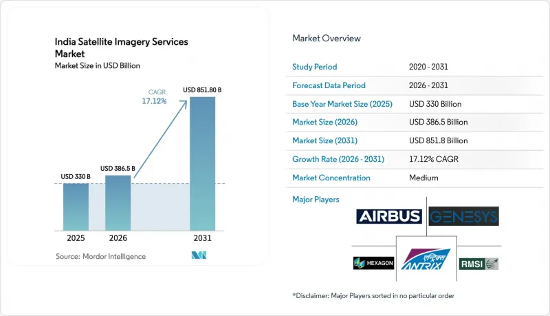
根據 Mordor Intelligence 預測,印度衛星影像服務市場規模將從 2025 年的 3.3 億美元成長到 2026 年的 3.865 億美元,然後在 2031 年達到 8.518 億美元,2026 年至 2031 年的複合年成長率為 17.12%。
本報告按應用領域(例如,地理空間資料收集與製圖、自然資源管理)、最終用戶(例如,政府、建築和基礎設施)、服務類型(例如,原始衛星資料、增值分析)以及成像類型(解析度和頻譜模式)進行分類。市場預測以美元(USD)計價。
印度衛星圖像服務市場的趨勢與洞察
2025年起,透過公私合營發射地球觀測衛星
IN-SPACe計畫的授權向私人企業開放了衛星發射市場,使得Pixel公司計畫在2025年1月發射的三顆高光譜遙測衛星叢集等衛星星系得以實現。創業投資資金和一項價值150億盧比的公私聯合競標吸引了許多全球大型企業和本土新創公司,將衛星重掃描間隔縮短至不到一天。較低的准入成本降低了保險公司、農業技術公司和物流營運商的進入門檻,擴大了印度的衛星圖像服務市場。與BlackSky和泰雷茲阿萊尼亞太空公司的合作引入了先進的任務管理和雲端交付能力,增強了印度國內的分析能力。因此,預計影像供應將超過以往的需求,市場動態也正從「數據稀缺」轉向「增值差異化」。
國防和邊境控制數位化項目
SBS-3計畫包含52顆衛星,致力於為爭議邊界沿線的全天候監視提供持續資金。軍民兩用有效載荷正在產生商業性連鎖反應,尤其是在基礎設施安全和資源監測領域,從而深化了印度的衛星影像服務市場。衛星間鏈路和人工智慧驅動的星載處理將決策週期從數小時縮短至數分鐘,推動了對近即時分析儀錶板的需求。本地採購條款促進了向民用製造商的技術轉讓,並提高了光學、合成孔徑雷達(SAR)和推進子系統的在地採購率。持續的軍事發射確保了民用客戶在和平時期抓住機會並租賃相關設備的基礎能力。
付費存取小於 1 公尺的 IRS 影像,這些影像低於 2018 年的標準。
印度新空間有限公司已將亞米級存檔資料的付費模式轉為其他模式,增加了農業技術、林業和城市規劃領域新創企業的投入成本。這些新創公司目前正在考慮是購買現有的印度數據還是獲取更新的國外圖像,這阻礙了國內能力建設。儘管「國家地理空間政策」取消了事先核准的障礙,但在具有競爭力的私人衛星星系擴大並降低國內價格之前,資金籌措缺口依然存在。
細分市場分析
到2025年,地理空間資料收集和測繪將佔總收入的28.24%,這反映了土地登記的現代化和全國地籍調查的趨勢。印度衛星影像服務市場受益於可預測的政府採購週期,從而確保了對光學、合成孔徑雷達(SAR)和雷射雷達(LiDAR)衍生產品的最低需求。由於62萬個村莊強制推行唯一的地塊識別碼,正射影像鑲嵌圖的年需求量正在成長,同時農村發展機構正在添加時間序列圖層用於資產審計。同時,災害管理部門正在將頻繁更新的影像整合到颶風減災工作流程中,並將一次性專案轉化為多年服務合約。
隨著補貼標準轉向地塊層級的指標,精密農業正以17.6%的複合年成長率快速擴張。基於衛星的養分缺乏地圖正在取代統一的化肥標準,促使化肥生產商為購買衛星影像提供資金。合作銀行正在將季節性生物量評分整合到貸款應用程式中,從而擴大印度衛星影像服務市場在農村地區的覆蓋範圍。從長遠來看,持續的農業需求將抵消測繪市場的逐步成熟,在保持高利潤分析業務機會的同時,也能在對價格敏感的用戶群中實現收入來源多元化。
預計到2025年,政府機構將佔銷售額的41.88%,這主要得益於國防、農村發展和智慧城市建設等領域對承包影像包的依賴支出。中央政府機構購買的是全州範圍的許可,而非專案特定的圖塊許可,這雖然促進了銷售量的成長,但也給重新競標帶來了價格壓力。儘管預算規模龐大,但採購流程的僵化也為更靈活的私部門客戶進入市場留下了空間。
受作物產量指數、房地產風險評分和即時洪水預警等因素的推動,金融和保險業預計將實現18.02%的複合年成長率。保險公司目前正簽訂全年監控數據契約,因為基於Sentinel-1的理賠支付模式已將理賠延遲減少了40%。銀行正在將類似的分析方法應用於房屋抵押貸款組合,並實現地理空間風險儀錶板的商業化。隨著基於交易的定價模式取代資本密集的授權模式,經常性收入正在提高印度衛星影像服務市場的客戶留存率。
其他好處:
- Excel格式的市場預測(ME)表
- 3個月的分析師支持
目錄
第1章:引言
- 研究假設和市場定義
- 調查範圍
第2章:調查方法
第3章執行摘要
第4章 市場狀況
- 市場概覽
- 市場促進因素
- 從2025年起,公營和私營部門將發射地球觀測衛星
- 國防和邊境控制數位化項目
- 精密農業補貼計畫(e-NAM 2.0、數位農業任務)
- 利用LiDAR進行智慧城市2.0強制性的城市規劃
- 六級颶風預警系統升級藍圖
- 用於全國5G高密度部署的衛星物聯網回程傳輸
- 市場限制因素
- 付費存取解析度低於 1 公尺的 IRS 影像,低於 2018 年基準值。
- 本地儲存資料的義務以及多個機構審查的延誤
- 國家營運的數據入口網站之間缺乏互通性
- 高光譜遙測影像負責人短缺
- 監理情勢
- 技術展望
- 波特五力分析
第5章 市場規模與成長預測
- 透過使用
- 地理空間資料的採集與製圖
- 自然資源管理
- 監控與安全
- 保護與調查
- 災害管理
- 智力
- 都市計畫與智慧城市
- 精密農業
- 最終用戶
- 政府
- 建築和基礎設施
- 運輸/物流
- 軍事/國防
- 林業和農業
- 能源公用事業
- 金融服務和保險
- 其他最終用戶
- 按服務類型
- 衛星原始數據
- 加值分析
- 平台即服務/API 訪問
- 按成像類型
- 解決
- 超高解析度(小於0.5公尺)
- 高解析度(0.5-1米)
- 中(1-5米)
- 低解析度(>5公尺)
- 頻譜模態
- 光學
- 合成孔徑雷達(SAR)
- 高光譜遙測
- 解決
第6章 競爭情勢
- 市場集中度
- 策略趨勢
- 市佔率分析
- 公司簡介
- Airbus SE
- Genesys International Corporation Limited
- Antrix Corporation Limited
- Hexagon AB
- RMSI Private Limited
- Maxar Technologies Inc.
- CE Info Systems Limited(MapmyIndia)
- Rolta India Limited
- Quantduo Technologies Private Limited
- GIS Consortium India Private Limited
- SatSure Analytics India Private Limited
- Planet Labs PBC
- Pixxel Space Technologies Private Limited
- Capella Space Corp.
- BlackSky Technology Inc.
- Satellogic USA Inc.
- NewSpace India Limited
- Spatial Views Private Limited
- GeoSpoc Geospatial Services Private Limited
- Earth-i Limited
- Kawa Space Private Limited
第7章 市場機會與未來展望
According to Mordor Intelligence, the India satellite imagery services market size is expected to grow from USD 330 million in 2025 to USD 386.5 million in 2026 and is forecast to reach USD 851.8 million by 2031 at 17.12% CAGR over 2026-2031.
This report is Segmented by Application (Geospatial Data Acquisition and Mapping, Natural Resource Management, and More), End-User (Government, Construction and Infrastructure, and More), Service Type (Raw Satellite Data, Value-Added Analytics, and More), and Imaging Type (Resolution and Spectral Modality). The Market Forecasts are Provided in Terms of Value (USD).
India Satellite Imagery Services Market Trends and Insights
Public-private EO satellite launches post-2025
IN-SPACe clearances opened the launch market to private firms, enabling constellations such as Pixxel's three-satellite hyperspectral cluster that flew in January 2025. Venture funding coupled with a Rs 1,500 crore public-private tender attracts global primes and local start-ups, driving revisit times down to sub-daily windows. Cheaper access lowers entry barriers for insurers, agritech firms and logistics operators, widening the India satellite imagery services market. Partnerships with BlackSky and Thales Alenia Space inject advanced tasking and cloud delivery capabilities, strengthening domestic analytics depth. As a result, imagery supply is set to outpace historical demand, pivoting market dynamics from data scarcity to value-added differentiation.
Defense and border management digitization programs
The SBS-3 program covering 52 satellites commits sustained funding to all-weather surveillance along contested borders. Dual-use payloads generate commercial spillovers, especially in infrastructure security and resource monitoring, thereby deepening the India satellite imagery services market. Inter-satellite links and AI-enabled onboard processing shrink decision loops from hours to minutes, feeding demand for near-real-time analytics dashboards. Indigenous sourcing clauses foster technology transfer to private manufacturers, lifting local content in optical, SAR and propulsion subsystems. The sustained cadence of military launches ensures baseline capacity that private clients can opportunistically lease during peacetime windows.
Fee-based access to less than 1 m IRS imagery below 2018 baseline
NewSpace India Limited shifted sub-meter archives to a paid model, raising input costs for agritech, forestry and urban-planning start-ups.Start-ups now weigh paying for legacy Indian data against sourcing fresher foreign imagery, which undercuts domestic capacity-building. Although the National Geospatial Policy removes prior-approval hurdles, the funding gap persists until competitive private constellations scale sufficiently to lower domestic prices.
Other drivers and restraints analyzed in the detailed report include:
- Precision-agri subsidy schemes (e-NAM 2.0, Digital Ag Mission)
- Mandated LiDAR-based city planning for Smart-Cities 2.0
- Data-localization and multi-agency clearance delays
For complete list of drivers and restraints, kindly check the Table Of Contents.
Segment Analysis
Geospatial Data Acquisition and Mapping commanded 28.24% of 2025 revenues, mirroring the land-record modernization push and nationwide cadastral surveys. The India satellite imagery services market benefits from predictable government procurement cycles, ensuring baseline utilization for optical, SAR and LiDAR-derived products. Mandated Unique Land Parcel IDs across 620,000 villages enlarge annual demand for ortho-rectified mosaics, while rural development agencies add time-series layers for asset audits. In parallel, disaster-management authorities integrate high-refresh imagery into cyclone preparedness workflows, converting episodic projects into multiyear service agreements.
Precision Agriculture expands at a 17.6% CAGR as subsidy disbursals pivot to plot-level indicators. Satellite-enabled nutrient deficiency maps replace blanket fertilizer norms, nudging fertilizer firms to fund imagery purchases. Cooperative banks embed seasonal biomass scores into lending apps, widening the India satellite imagery services market's rural footprint. Over time, sustained agri demand offsets mapping's gradual maturation, diversifying revenue streams across more price-sensitive user groups while preserving high-margin analytics opportunities.
Government buyers represented 41.88% of 2025 turnover, buoyed by defense, rural-development and smart-city outlays that rely on turnkey imagery bundles. Central agencies purchase statewide licenses rather than project-specific tiles, underpinning volume growth but exerting price pressure during rebids. Despite budget heft, procurement rigidity leaves white spaces open to agile private customers.
Financial Services and Insurance is on track for an 18.02% CAGR, fed by crop-yield indices, property-risk scores and real-time flood alerts. Sentinel-1-based indemnity models cut claim-settlement lags by 40%, prompting insurers to subscribe to season-long monitoring feeds. Banks extend similar analytics to mortgage portfolios, monetizing geospatial risk dashboards. As transaction-based pricing replaces capex-heavy licensing, recurring revenues deepen stickiness within the India satellite imagery services market.
Complete Report Scope:
- By Application
- Geospatial Data Acquisition and Mapping
- Natural Resource Management
- Surveillance and Security
- Conservation and Research
- Disaster Management
- Intelligence
- Urban Planning and Smart Cities
- Precision Agriculture
- By End-User
- Government
- Construction and Infrastructure
- Transportation and Logistics
- Military and Defense
- Forestry and Agriculture
- Energy and Utilities
- Financial Services and Insurance
- Other End-Users
- By Service Type
- Raw Satellite Data
- Value-Added Analytics
- Platform-as-a-Service / API Access
- By Imaging Type
- Resolution
- Very High ( less than 0.5 m)
- High (0.5-1 m)
- Medium (1-5 m)
- Low ( above 5 m)
- Spectral Modality
- Optical
- Synthetic Aperture Radar (SAR)
- Hyperspectral
- Resolution
List of Companies Covered in this Report:
- Airbus SE
- Genesys International Corporation Limited
- Antrix Corporation Limited
- Hexagon AB
- RMSI Private Limited
- Maxar Technologies Inc.
- C.E. Info Systems Limited (MapmyIndia)
- Rolta India Limited
- Quantduo Technologies Private Limited
- GIS Consortium India Private Limited
- SatSure Analytics India Private Limited
- Planet Labs PBC
- Pixxel Space Technologies Private Limited
- Capella Space Corp.
- BlackSky Technology Inc.
- Satellogic USA Inc.
- NewSpace India Limited
- Spatial Views Private Limited
- GeoSpoc Geospatial Services Private Limited
- Earth-i Limited
- Kawa Space Private Limited
Additional Benefits:
- The market estimate (ME) sheet in Excel format
- 3 months of analyst support
TABLE OF CONTENTS
1 INTRODUCTION
- 1.1 Study Assumptions and Market Definition
- 1.2 Scope of the Study
2 RESEARCH METHODOLOGY
3 EXECUTIVE SUMMARY
4 MARKET LANDSCAPE
- 4.1 Market Overview
- 4.2 Market Drivers
- 4.2.1 Public-private EO satellite launches post-2025
- 4.2.2 Defence and border management digitisation programmes
- 4.2.3 Precision-agri subsidy schemes (e-NAM 2.0, Digital Ag Mission)
- 4.2.4 Mandated LiDAR-based city planning for Smart-Cities 2.0
- 4.2.5 Cat-6 cyclone early-warning upgrade roadmap
- 4.2.6 Satellite-IoT back-haul for nationwide 5G densification
- 4.3 Market Restraints
- 4.3.1 Fee-based access to less than 1 m IRS imagery below 2018 baseline
- 4.3.2 Data-localisation and multi-agency clearance delays
- 4.3.3 Limited interoperability across state-run data portals
- 4.3.4 Shortage of hyperspectral image analysts
- 4.4 Regulatory Landscape
- 4.5 Technological Outlook
- 4.6 Porter's Five Forces Analysis
- 4.6.1 Bargaining Power of Buyers
- 4.6.2 Bargaining Power of Suppliers
- 4.6.3 Threat of New Entrants
- 4.6.4 Threat of Substitutes
- 4.6.5 Intensity of Competitive Rivalry
5 MARKET SIZE AND GROWTH FORECASTS (VALUE)
- 5.1 By Application
- 5.1.1 Geospatial Data Acquisition and Mapping
- 5.1.2 Natural Resource Management
- 5.1.3 Surveillance and Security
- 5.1.4 Conservation and Research
- 5.1.5 Disaster Management
- 5.1.6 Intelligence
- 5.1.7 Urban Planning and Smart Cities
- 5.1.8 Precision Agriculture
- 5.2 By End-User
- 5.2.1 Government
- 5.2.2 Construction and Infrastructure
- 5.2.3 Transportation and Logistics
- 5.2.4 Military and Defense
- 5.2.5 Forestry and Agriculture
- 5.2.6 Energy and Utilities
- 5.2.7 Financial Services and Insurance
- 5.2.8 Other End-Users
- 5.3 By Service Type
- 5.3.1 Raw Satellite Data
- 5.3.2 Value-Added Analytics
- 5.3.3 Platform-as-a-Service / API Access
- 5.4 By Imaging Type
- 5.4.1 Resolution
- 5.4.1.1 Very High ( less than 0.5 m)
- 5.4.1.2 High (0.5-1 m)
- 5.4.1.3 Medium (1-5 m)
- 5.4.1.4 Low ( above 5 m)
- 5.4.2 Spectral Modality
- 5.4.2.1 Optical
- 5.4.2.2 Synthetic Aperture Radar (SAR)
- 5.4.2.3 Hyperspectral
- 5.4.1 Resolution
6 COMPETITIVE LANDSCAPE
- 6.1 Market Concentration
- 6.2 Strategic Moves
- 6.3 Market Share Analysis
- 6.4 Company Profiles (includes Global level Overview, Market level overview, Core Segments, Financials as available, Strategic Information, Market Rank/Share for key companies, Products and Services, and Recent Developments)
- 6.4.1 Airbus SE
- 6.4.2 Genesys International Corporation Limited
- 6.4.3 Antrix Corporation Limited
- 6.4.4 Hexagon AB
- 6.4.5 RMSI Private Limited
- 6.4.6 Maxar Technologies Inc.
- 6.4.7 C.E. Info Systems Limited (MapmyIndia)
- 6.4.8 Rolta India Limited
- 6.4.9 Quantduo Technologies Private Limited
- 6.4.10 GIS Consortium India Private Limited
- 6.4.11 SatSure Analytics India Private Limited
- 6.4.12 Planet Labs PBC
- 6.4.13 Pixxel Space Technologies Private Limited
- 6.4.14 Capella Space Corp.
- 6.4.15 BlackSky Technology Inc.
- 6.4.16 Satellogic USA Inc.
- 6.4.17 NewSpace India Limited
- 6.4.18 Spatial Views Private Limited
- 6.4.19 GeoSpoc Geospatial Services Private Limited
- 6.4.20 Earth-i Limited
- 6.4.21 Kawa Space Private Limited
7 MARKET OPPORTUNITIES AND FUTURE OUTLOOK
- 7.1 White-space and Unmet-Need Assessment


