

 |
市場調查報告書
商品編碼
2109182
軍事地理空間資訊市場:商業機會、成長要素、產業趨勢分析及2026-2035年預測Military Geospatial Intelligence Market Opportunity, Growth Drivers, Industry Trend Analysis, and Forecast 2026 - 2035 |
||||||

全球軍事地理空間資訊市場預計到 2025 年價值 132 億美元,年複合成長率為 9.7%,到 2035 年將達到 331 億美元。
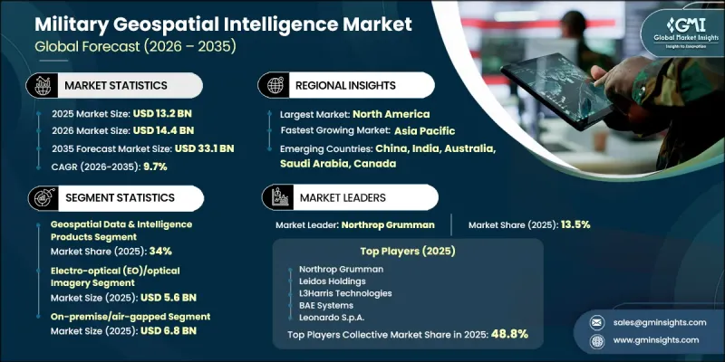
市場成長的促進因素包括:對衛星情報收集能力的投資增加、人工智慧(AI)在地理空間資料分析中的更廣泛應用、合成孔徑雷達(SAR)衛星網路的持續發展,以及多域軍事行動日益成長的重要性。此外,加強國家安全和建立獨立的地理空間情報能力的日益重視,也為整個國防領域創造了長期機會。國防機構正在增加對先進監視技術的投資,以提高情境察覺、任務規劃和作戰決策能力。對精確、即時資訊的需求不斷成長,加上遙感探測和自動化分析技術的持續進步,正在加速市場擴張。隨著軍事組織對其國防基礎設施進行現代化改造並增強其數位戰場能力,預計在整個預測期內,對先進地理空間情報平台、高品質影像和數據驅動型國防解決方案的需求將保持強勁。
| 市場範圍 | |
|---|---|
| 開始年份 | 2025 |
| 預測期 | 2026-2035 |
| 上市時的市場規模 | 132億美元 |
| 預測金額 | 331億美元 |
| 複合年成長率 | 9.7% |
對衛星情報、監視和偵察(ISR)能力的投資不斷增加,顯著推動了軍事地理空間資訊市場的擴張。世界各國政府正在擴展天基防禦基礎設施,以增強持續的地球觀測、即時戰場監視和戰略情報收集能力。同時,人工智慧(AI)正成為現代地理空間資訊不可或缺的組成部分,它能夠快速處理大規模資料集、自動影像解譯,並提高軍事決策的速度和準確性。人工智慧驅動的分析還能將大量地理空間資料轉化為可操作的洞察,進而增強目標識別、資訊產生和作戰規劃能力。這些技術進步使國防機構能夠提高任務準備度、增強監視能力,並最佳化各種軍事行動中的資源分配。
預計到2025年,地理空間資料和資訊產品領域將佔據34%的市場。由於對高解析度地理空間資訊、數位地形模型、地圖資料庫以及支援任務規劃、態勢感知、監視、目標評估和戰略軍事決策的資訊產品的需求不斷成長,該領域將繼續保持主導地位。對先進地球觀測能力的持續投資以及對加強國內地理空間資訊資源的日益重視,預計將維持國防和國防安全保障應用領域的長期需求。
預計到2025年,光電/光學成像市場規模將達56億美元。偵察、監視、戰場評估和目標識別等領域對高品質影像的強勁需求持續推動著該領域的成長。光電技術可提供清晰的晝夜成像,有助於提升作戰規劃、邊境監視和精確防禦任務的效率。成像技術的不斷進步,以及在飛機、衛星和無人防禦平台上的日益廣泛的應用,正進一步推動光電解決方案在整體的應用。
預計到2025年,北美軍事地理空間資訊市場佔有率將達到44%。該地區繼續引領產業發展,這主要得益於國防費用的不斷成長,尤其是對天基情報、監視和偵察能力的投入,以及人工智慧驅動的地理空間資訊平台的日益普及。先進的衛星技術、安全的資訊基礎設施、即時數據處理能力以及對下一代國防系統的持續投資,都為該地區的市場成長提供了支撐。軍事行動的持續現代化以及對安全地理空間資訊解決方案日益成長的重視,預計將在預測期內進一步鞏固北美在該領域的主導地位。
目錄
第1章:調查方法和範圍
第2章執行摘要
第3章 行業洞察
- 產業生態系分析
- 供應商情況
- 利潤率
- 成本結構
- 每個階段增加的價值
- 影響價值鏈的因素
- 中斷
- 影響產業的因素
- 促進因素
- 加大對衛星情報、監視與偵察能力的國防投資
- 人工智慧(AI)在地理空間資訊分析中的快速應用
- 擴大高解析度地球觀測衛星和合成孔徑雷達衛星星系。
- 擴大多域軍事行動的採用
- 擴大國家地理空間資訊能力,確保國家安全資料的自主性。
- 產業潛在風險與挑戰
- 衛星基礎設施和先進地球智慧系統成本高昂
- 網路安全風險與資料安全問題
- 市場機遇
- 擴展人工智慧驅動的地理空間分析和自主智慧處理。
- 擴大小型衛星星系的部署,加強國家航太能力
- 促進因素
- 成長潛力分析
- 監理情勢
- 波特的分析
- PESTLE分析
- 技術與創新展望
- 最新科技趨勢
- 新興技術
- 價格趨勢
- 按地區
- 依產品
- 定價策略
- 新興經營模式
- 合規要求
- 專利和智慧財產權分析
第4章 競爭情勢
- 介紹
- 企業市佔率分析
- 按地區
- 市場集中度分析
- 主要公司的競爭標竿分析
- 財務績效比較
- 收入
- 利潤率
- R&D
- 產品系列比較
- 產品線寬度
- 科技
- 創新
- 區域擴張比較
- 全球擴張分析
- 服務網路覆蓋
- 按地區分類的市場滲透率
- 競爭定位矩陣
- 領導者
- 挑戰者
- 追蹤者
- 小眾玩家
- 戰略展望矩陣
- 財務績效比較
- 主要進展
- 併購
- 夥伴關係和聯盟
- 技術進步
- 擴張和投資策略
- 數位轉型計劃
- 新興企業競爭公司和新創企業的發展趨勢
第5章 市場估算與預測:依產品類型分類,2022-2035年
- 地理空間情報採集系統與有效載荷
- 地理空間資料和情報產品
- 地理空間資訊軟體
- 地理空間資訊服務
第6章 市場估計與預測:依應用領域分類,2022-2035年
- 資訊收集和監視
- 目標定位和精確打擊支援
- 任務規劃與地形分析
- 戰場態勢評估與指揮控制
- 邊境/海岸/海上安全活動
- 利用地理空間情報在 GPS 不可用的環境中進行導航和操作。
- 訓練、模擬和任務演練
第7章 市場估計與預測:依技術分類,2022-2035年
- 光電成像/光學成像
- 合成孔徑雷達(SAR)
- 高光譜遙測和頻譜成像
- 全動態視訊 (FMV) 和廣域影片(WAMI)
- LiDAR與3D地形測繪
第8章 市場估算與預測:依實施平台分類,2022-2035年
- 本地部署/空氣間隙
- 政府雲端(GovCloud)
- 混合
第9章 市場估價與預測:依最終用戶分類,2022-2035年
- 陸軍/地面部隊
- 海軍/海軍部隊
- 空軍/航太部隊
- 綜合/多學科指揮與控制
- 情報機構
- 國防安全保障和邊防安全(包括海岸警衛隊)
- 各國地圖及地理空間組織
第10章 市場估價與預測:依地區分類,2022-2035年
- 北美洲
- 美國
- 加拿大
- 歐洲
- 德國
- 英國
- 法國
- 俄羅斯
- 義大利
- 亞太地區
- 中國
- 印度
- 日本
- 澳洲
- 拉丁美洲
- 巴西
- 墨西哥
- 阿根廷
- 中東和非洲
- 沙烏地阿拉伯
- 埃及
第11章:公司簡介
- 全球主要公司
- Northrop Grumman
- Leidos Holdings
- L3Harris Technologies
- BAE Systems
- Leonardo SpA
- 該地區的主要公司
- 北美洲
- Vantor
- Esri
- Palantir Technologies
- Planet Labs PBC
- BlackSky Technology
- Capella Space
- HawkEye 360
- 亞太地區
- Elbit Systems Ltd.
- 歐洲
- Airbus Defence & Space
- Thales Group
- Saab AB
- ICEYE
- 北美洲
- 小眾玩家/顛覆者
- Umbra(Umbra Lab Inc.)
The Global Military Geospatial Intelligence Market was valued at USD 13.2 billion in 2025 and is estimated to grow at a CAGR of 9.7% to reach USD 33.1 billion by 2035.
Market growth is fueled by increasing investments in satellite-based intelligence capabilities, broader integration of artificial intelligence into geospatial data analysis, continuous development of synthetic aperture radar (SAR) satellite networks, and the growing importance of multi-domain military operations. Rising emphasis on strengthening national security and achieving independent geospatial intelligence capabilities is also creating long-term opportunities across the defense sector. Defense organizations are expanding their investments in advanced surveillance technologies to improve situational awareness, mission planning, and operational decision-making. The growing need for accurate, real-time intelligence, combined with continuous advancements in remote sensing technologies and automated analytics, is accelerating market expansion. As military organizations modernize defense infrastructure and enhance digital battlefield capabilities, demand for advanced geospatial intelligence platforms, high-quality imagery, and data-driven defense solutions is expected to remain strong throughout the forecast period.
| Market Scope | |
|---|---|
| Start Year | 2025 |
| Forecast Year | 2026-2035 |
| Start Value | $13.2 Billion |
| Forecast Value | $33.1 Billion |
| CAGR | 9.7% |
Growing investments in satellite-enabled intelligence, surveillance, and reconnaissance capabilities are significantly contributing to the expansion of the military geospatial intelligence market. Governments worldwide are strengthening their space-based defense infrastructure to improve persistent Earth observation, real-time battlefield monitoring, and strategic intelligence collection. At the same time, artificial intelligence is becoming an essential component of modern geospatial intelligence by enabling rapid processing of large datasets, automating image interpretation, and improving the speed and accuracy of military decision-making. AI-powered analytics also enhance target recognition, intelligence generation, and operational planning by transforming vast amounts of geospatial information into actionable insights. These technological advancements are enabling defense organizations to improve mission readiness, strengthen surveillance capabilities, and optimize resource allocation across a wide range of military operations.
The geospatial data and intelligence products segment accounted for 34% share in 2025. The segment maintains its leading position due to the growing demand for high-resolution geospatial information, digital terrain models, mapping databases, and intelligence products that support mission planning, operational awareness, surveillance, target assessment, and strategic military decision-making. Continued investments in advanced Earth observation capabilities and increasing focus on strengthening domestic geospatial intelligence resources are expected to sustain long-term demand across defense and homeland security applications.
The electro-optical (EO)/optical imagery segment generated USD 5.6 billion in 2025. Strong demand for high-quality imagery used in reconnaissance, surveillance, battlefield assessment, and target identification continues to support segment growth. Electro-optical technologies provide detailed daytime imaging that enhances operational planning, border monitoring, and precision defense missions. Continuous improvements in imaging technologies, combined with wider deployment across airborne, satellite, and unmanned defense platforms, are further expanding the adoption of electro-optical solutions throughout modern military operations.
North America Military Geospatial Intelligence Market accounted for 44% share in 2025. The region continues to lead industry due to rising defense expenditures focused on space-based intelligence, surveillance, and reconnaissance capabilities, together with increasing deployment of artificial intelligence-driven geospatial intelligence platforms. Ongoing investments in advanced satellite technologies, secure intelligence infrastructure, real-time data processing capabilities, and next-generation defense systems are supporting regional market growth. The continued modernization of military operations and the increasing emphasis on secure geospatial intelligence solutions are expected to reinforce North America's leadership position during the forecast period.
Key players in the global military geospatial intelligence market include Leidos Holdings, Umbra (Umbra Lab Inc.), Esri, BAE Systems plc, Northrop Grumman Corporation, Palantir Technologies, Airbus Defence & Space, Capella Space, HawkEye 360, Saab AB, ICEYE, Leonardo S.p.A., L3Harris Technologies, Elbit Systems Ltd., BlackSky Technology, Thales Group, Vantor, Planet Labs PBC. Companies operating in the military geospatial intelligence market are strengthening their market position through continuous investments in advanced satellite technologies, artificial intelligence integration, and next-generation geospatial analytics platforms. Leading participants are expanding research and development activities to improve imaging capabilities, enhance real-time intelligence processing, and deliver highly accurate geospatial data for defense applications. Strategic collaborations with government agencies, defense organizations, and technology providers are helping companies broaden their solution portfolios and strengthen long-term contracts. Organizations are also focusing on cloud-enabled intelligence platforms, secure data management systems, and advanced analytics to improve operational efficiency. Geographic expansion, product innovation, technology upgrades, and long-term defense modernization partnerships remain key strategies adopted to increase competitiveness and reinforce their presence in the global military geospatial intelligence market.
Table of Contents
Chapter 1 Methodology and Scope
- 1.1 Market scope and definition
- 1.2 Research design
- 1.2.1 Research approach
- 1.2.2 Data collection methods
- 1.3 Data mining sources
- 1.3.1 Global
- 1.3.2 Regional/Country
- 1.4 Base estimates and calculations
- 1.4.1 Base year calculation
- 1.4.2 Key trends for market estimation
- 1.5 Primary research and validation
- 1.5.1 Primary sources
- 1.6 Forecast model
- 1.7 Research assumptions and limitations
Chapter 2 Executive Summary
- 2.1 Industry 360° synopsis, 2022 - 2035
- 2.2 Key market trends
- 2.2.1 Offering trends
- 2.2.2 Application trends
- 2.2.3 Technology trends
- 2.2.4 Deployment platform trends
- 2.2.5 End-user trends
- 2.2.6 Regional trends
- 2.3 TAM Analysis, 2026-2035
- 2.4 CXO perspectives: Strategic imperatives
Chapter 3 Industry Insights
- 3.1 Industry ecosystem analysis
- 3.1.1 Supplier Landscape
- 3.1.2 Profit Margin
- 3.1.3 Cost structure
- 3.1.4 Value addition at each stage
- 3.1.5 Factor affecting the value chain
- 3.1.6 Disruptions
- 3.2 Industry impact forces
- 3.2.1 Growth drivers
- 3.2.1.1 Increasing defense investments in satellite-based ISR capabilities
- 3.2.1.2 Rapid integration of Artificial Intelligence (AI) into geospatial intelligence analysis
- 3.2.1.3 Growing deployment of high-resolution Earth observation and SAR satellite constellations
- 3.2.1.4 Increasing adoption of multi-domain military operations
- 3.2.1.5 Expansion of sovereign geospatial intelligence capabilities and national security data autonomy
- 3.2.2 Industry pitfalls and challenges
- 3.2.2.1 High cost of satellite infrastructure and advanced GEOINT systems
- 3.2.2.2 Cybersecurity risks and data security concerns
- 3.2.3 Market opportunities
- 3.2.3.1 Expansion of AI-powered geospatial analytics and autonomous intelligence processing
- 3.2.3.2 Growing deployment of small satellite constellations and sovereign space capabilities
- 3.2.1 Growth drivers
- 3.3 Growth potential analysis
- 3.4 Regulatory landscape
- 3.4.1 North America
- 3.4.2 Europe
- 3.4.3 Asia Pacific
- 3.4.4 Latin America
- 3.4.5 Middle East & Africa
- 3.5 Porter's analysis
- 3.6 PESTEL analysis
- 3.7 Technology and Innovation landscape
- 3.7.1 Current technological trends
- 3.7.2 Emerging technologies
- 3.8 Price trends
- 3.8.1 By region
- 3.8.2 By product
- 3.9 Pricing Strategies
- 3.10 Emerging Business Models
- 3.11 Compliance Requirements
- 3.12 Patent and IP analysis
Chapter 4 Competitive Landscape, 2025
- 4.1 Introduction
- 4.2 Company market share analysis
- 4.2.1 By region
- 4.2.1.1 North America
- 4.2.1.2 Europe
- 4.2.1.3 Asia Pacific
- 4.2.1.4 Latin America
- 4.2.1.5 Middle East & Africa
- 4.2.2 Market concentration analysis
- 4.2.1 By region
- 4.3 Competitive benchmarking of key players
- 4.3.1 Financial performance comparison
- 4.3.1.1 Revenue
- 4.3.1.2 Profit margin
- 4.3.1.3 R&D
- 4.3.2 Product portfolio comparison
- 4.3.2.1 Product range breadth
- 4.3.2.2 Technology
- 4.3.2.3 Innovation
- 4.3.3 Geographic presence comparison
- 4.3.3.1 Global footprint analysis
- 4.3.3.2 Service network coverage
- 4.3.3.3 Market penetration by region
- 4.3.4 Competitive positioning matrix
- 4.3.4.1 Leaders
- 4.3.4.2 Challengers
- 4.3.4.3 Followers
- 4.3.4.4 Niche players
- 4.3.5 Strategic outlook matrix
- 4.3.1 Financial performance comparison
- 4.4 Key developments
- 4.4.1 Mergers and acquisitions
- 4.4.2 Partnerships and collaborations
- 4.4.3 Technological advancements
- 4.4.4 Expansion and investment strategies
- 4.4.5 Digital transformation initiatives
- 4.5 Emerging/ startup competitors landscape
Chapter 5 Market Estimates and Forecast, By Offering, 2022 - 2035 (USD Million)
- 5.1 Key trends
- 5.2 GEOINT collection systems & payloads
- 5.3 Geospatial data & intelligence products
- 5.4 Geospatial intelligence software
- 5.5 Geospatial intelligence services
Chapter 6 Market Estimates and Forecast, By Application, 2022 - 2035 (USD Million)
- 6.1 Key trends
- 6.2 Intelligence collection & surveillance
- 6.3 Targeting & precision strike support
- 6.4 Mission planning & terrain analysis
- 6.5 Battlespace awareness & command & control
- 6.6 Border, coastal & maritime security operations
- 6.7 GEOINT-enabled navigation & GPS-denied operations
- 6.8 Training, simulation & mission rehearsal
Chapter 7 Market Estimates and Forecast, By Technology, 2022 - 2035 (USD Million)
- 7.1 Key trends
- 7.2 Electro-optical (EO)/optical imagery
- 7.3 Synthetic aperture radar (SAR)
- 7.4 Hyperspectral & multispectral imaging
- 7.5 Full motion video (FMV) & wide-area motion imagery (WAMI)
- 7.6 LiDAR & 3D terrain mapping
Chapter 8 Market Estimates and Forecast, By Deployment Platform, 2022 - 2035 (USD Million)
- 8.1 Key trends
- 8.2 On-premise/air-gapped
- 8.3 Government cloud (GovCloud)
- 8.4 Hybrid
Chapter 9 Market Estimates and Forecast, By End-User, 2022 - 2035 (USD Million)
- 9.1 Key trends
- 9.2 Army / land forces
- 9.3 Navy / naval forces
- 9.4 Air force / aerospace forces
- 9.5 Joint & multi-domain commands
- 9.6 Intelligence agencies
- 9.7 Homeland security & border protection (incl. Coast Guards)
- 9.8 National mapping & geospatial agencies
Chapter 10 Market Estimates and Forecast, By Region, 2022 - 2035 (USD Million)
- 10.1 Key trends
- 10.2 North America
- 10.2.1 U.S.
- 10.2.2 Canada
- 10.3 Europe
- 10.3.1 Germany
- 10.3.2 UK
- 10.3.3 France
- 10.3.4 Russia
- 10.3.5 Italy
- 10.4 Asia Pacific
- 10.4.1 China
- 10.4.2 India
- 10.4.3 Japan
- 10.4.4 Australia
- 10.5 Latin America
- 10.5.1 Brazil
- 10.5.2 Mexico
- 10.5.3 Argentina
- 10.6 Middle East and Africa
- 10.6.1 Saudi Arabia
- 10.6.2 Egypt
Chapter 11 Company Profiles
- 11.1 Global Key Players
- 11.1.1 Northrop Grumman
- 11.1.2 Leidos Holdings
- 11.1.3 L3Harris Technologies
- 11.1.4 BAE Systems
- 11.1.5 Leonardo S.p.A.
- 11.2 Regional key players
- 11.2.1 North America
- 11.2.1.1 Vantor
- 11.2.1.2 Esri
- 11.2.1.3 Palantir Technologies
- 11.2.1.4 Planet Labs PBC
- 11.2.1.5 BlackSky Technology
- 11.2.1.6 Capella Space
- 11.2.1.7 HawkEye 360
- 11.2.2 Asia Pacific
- 11.2.2.1 Elbit Systems Ltd.
- 11.2.3 Europe
- 11.2.3.1 Airbus Defence & Space
- 11.2.3.2 Thales Group
- 11.2.3.3 Saab AB
- 11.2.3.4 ICEYE
- 11.2.1 North America
- 11.3 Niche Players/Disruptors
- 11.3.1 Umbra (Umbra Lab Inc.)

 用於地理空間環境測繪的人工智慧市場分析及預測(至2035年):按類型、產品、服務、技術、組件、應用、部署方式、最終用戶和解決方案分類
 地理空間資訊市場規模、佔有率和趨勢分析報告:按組件、技術、應用、行業、地區和細分市場預測(2026-2033 年)
 地理空間解決方案市場:按組件、技術、資料來源、平台、應用、最終用戶產業、部署模式和組織規模分類-2026-2032年全球市場預測
 2026年全球地理空間解決方案市場報告地理空間解決方案市場分析及預測(至2035年):按類型、產品類型、服務、技術、組件、應用、最終用戶、部署類型和功能分類
 全球地理空間解決方案市場規模、佔有率、趨勢和成長分析報告(2026-2034年)
 按組件、技術、應用、最終用戶行業、部署類型和地區分類的地理市場規模、佔有率和成長分析 - 2026-2033 年行業預測
 全球地理空間智慧市場:地理空間人工智慧、地理空間分析、擷取系統與技術—預測至2030年
 地理空間解決方案市場-全球產業規模、佔有率、趨勢、機會和預測(按解決方案類型、技術、應用、最終用途、地區和競爭格局分類,2021-2031年預測)
 全球地理空間解決方案市場:產業分析、規模、佔有率、成長、趨勢與預測,2025-2032 年