


 |
市場調查報告書
商品編碼
1773241
土地測量設備市場機會、成長動力、產業趨勢分析及 2025 - 2034 年預測Land Survey Equipment Market Opportunity, Growth Drivers, Industry Trend Analysis, and Forecast 2025 - 2034 |
||||||
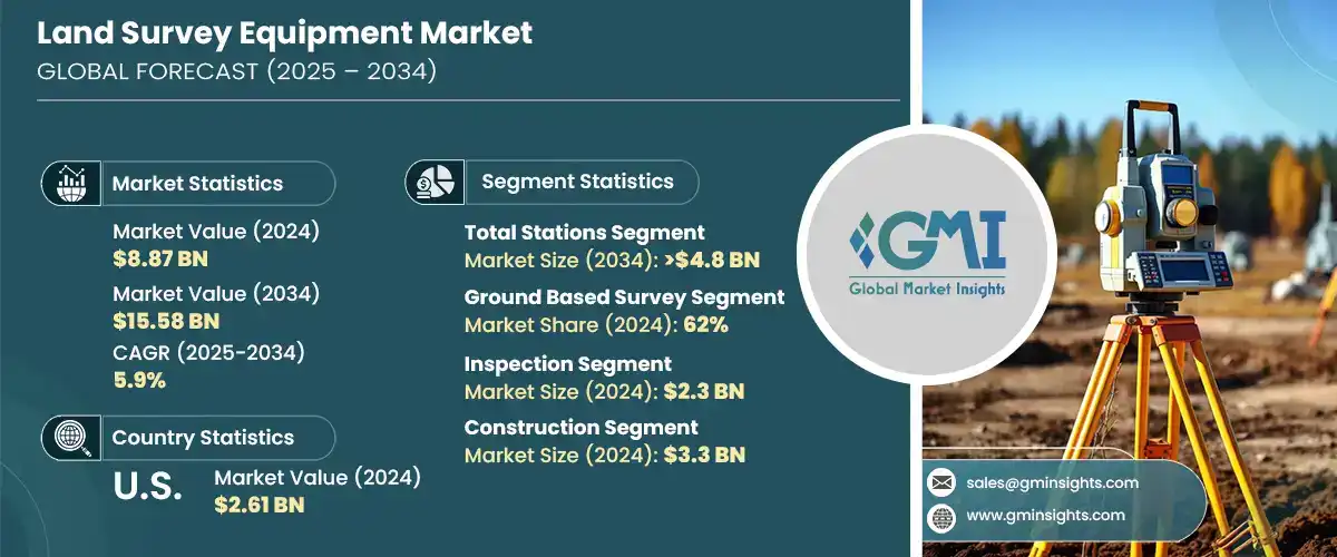
2024 年全球土地測量設備市場價值為 88.7 億美元,預計到 2034 年將以 5.9% 的複合年成長率成長,達到 155.8 億美元。農業、建築、基礎設施和採礦等行業對精確地理空間資訊日益成長的需求推動了這一成長。隨著各行各業持續優先考慮效率、安全和精度,對下一代測量技術的需求日益成長。傳統測量技術正迅速被 GNSS 接收器、機器人全站儀和 3D 雷射掃描儀等先進工具所取代。這些解決方案使測量人員能夠更快、更準確地收集資料,從而改善地形測繪並更好地執行專案。從最佳化農業土地利用到提高採礦作業安全性,測量技術已成為眾多應用中不可或缺的一部分。
如今,全球各行各業越來越意識到這些現代儀器為複雜的土地開發和規劃專案帶來的優勢。這些先進的測量工具,例如全球導航衛星系統 (GNSS) 接收器、機器人全站儀和 3D 雷射掃描儀,提供無與倫比的精度、更快的資料收集和即時分析,有助於縮短專案工期並消除代價高昂的錯誤。從基礎設施開發和交通規劃到大規模農業和採礦作業,在極短時間內捕捉高解析度空間資料的能力徹底改變了專案的啟動、管理和執行方式。建築、公用事業和能源等行業也正在轉向這些創新,以簡化工作流程,提高測繪和建模的準確性,並遵守日益嚴格的安全和環境影響法規。
| 市場範圍 | |
|---|---|
| 起始年份 | 2024 |
| 預測年份 | 2025-2034 |
| 起始值 | 88.7億美元 |
| 預測值 | 155.8億美元 |
| 複合年成長率 | 5.9% |
2024年,全站儀市場佔據34.04%的市場佔有率,預計到2034年將達到48億美元。全站儀整合角度和距離測量功能,使其在高精度測量中極具價值。其多功能性和成本效益使其成為各行各業的首選工具,尤其是在交通運輸和城市基礎設施建設領域。 GNSS相容性、無線連接和機器人自動化等最新創新正在簡化工作流程並擴展其功能。
地面測量系統細分市場在2024年佔據62%的市場佔有率,預計2025年至2034年的複合年成長率為5%。此類別涵蓋傳統和現代土地測量設備,例如全球導航衛星系統(GNSS)、水準儀和全站儀。其適應性、可靠性和便利性使其適用於廣泛的專案範圍,尤其是在建築和城市規劃等領域。地面測量在亞洲和歐洲等高成長市場中仍然至關重要,因為這些地區的大型城市基礎設施持續推動需求。
2024年,美國土地測量設備市場佔77.1%的市場佔有率,產值達26.1億美元。北美在採用先進土地測量系統方面處於全球領先地位,這些系統包括人工智慧整合分析、3D掃描技術和基於無人機的測量工具。美國市場以其快速擁抱數位化而脫穎而出,尤其是在智慧基礎設施和建築數位化方面。 Hexagon和Trimble等公司透過持續投資於產品升級、研發和數位化轉型,以滿足日益成長的即時高精度資料需求,在塑造該地區技術格局方面發揮著重要作用。
影響土地測量設備產業的關鍵參與者包括 GeoTech、Hexagon、Topcon、Trimble、Stonex、DeepWell、FARO、Bosch Tools、Emlid Tech 和上海華測導航技術有限公司。土地測量設備市場的公司正在大力投資研發,以創造創新、多功能和高精度的解決方案,滿足不斷變化的產業需求。許多公司將人工智慧、物聯網和無線技術整合到測量設備中,以增強自動化、即時資料處理和雲端相容性。與建築和基礎設施公司的合作夥伴關係和策略合作也是擴大客戶群的關鍵。參與者正強調開發緊湊、堅固且易於移動的設備,以應對偏遠地區和城市測量的挑戰。此外,公司正在本地化生產和支援服務,以更好地滿足區域市場的需求,同時注重設備的永續性和長期適用性。
目錄
第1章:方法論與範圍
第2章:執行摘要
第3章:行業洞察
- 產業生態系統分析
- 供應商格局
- 電子元件供應商
- 設備製造商
- 服務提供者
- 系統整合商
- 最終用途
- 成本結構
- 利潤率
- 每個階段的增值
- 影響供應鏈的因素
- 破壞者
- 供應商格局
- 對部隊的影響
- 成長動力
- 全球基礎設施繁榮推動對精確土地測量的需求
- GNSS、3D 掃描儀和無人機徹底改變了土地測量
- 農民和礦工利用測量技術進行精準作業
- GIS 擴展推動對勘測級地理空間資料的需求
- 產業陷阱與挑戰
- GNSS 和 3D 掃描儀的高成本限制了小型測量公司的發展
- 技能差距阻礙了先進測量技術的採用
- 市場機會
- 政府土地評估授權維持測量需求
- 整合 AR/VR 以實現遠端培訓和即時調查協助
- 成長動力
- 成長潛力分析
- 波特的分析
- PESTEL分析
- 技術與創新格局
- 現有技術
- 高精度 RTK 和 PPK GNSS/GPS 系統
- 機器人和電動全站儀
- 3D雷射掃描儀中的地面和移動LiDAR
- 攝影測量與 LiDAR 測繪無人機/無人駕駛飛機
- 新興技術
- 用於資料處理的人工智慧和機器學習
- 自主測量機器人
- 擴增實境 (AR) 用於現場可視化
- 用於安全地理空間資料管理的區塊鏈
- 現有技術
- 專利分析
- 監管格局
- 北美洲
- 歐洲
- 亞太地區
- 拉丁美洲
- 中東和非洲
- 生產統計
- 生產中心
- 消費中心
- 匯出和匯入
- 成本細分分析
- 永續性分析
- 永續實踐
- 減少廢棄物的策略
- 生產中的能源效率
- 環保舉措
- 碳足跡考量
第4章:競爭格局
- 介紹
- 公司市佔率分析
- 北美洲
- 歐洲
- 亞太地區
- 拉丁美洲
- 中東和非洲
- 競爭定位矩陣
- 戰略展望矩陣
- 關鍵進展
- 併購
- 夥伴關係與合作
- 新產品發布
- 擴張計劃和資金
第5章:市場估計與預測:按產品,2021 - 2034 年
- 主要趨勢
- 全站儀
- GPS/GNSS 系統
- 雷射掃描儀
- 等級
- 無人駕駛飛行器(UAV)/無人機
- 其他
第6章:市場估計與預測:依調查方法,2021 - 2034 年
- 主要趨勢
- 地面勘測
- 雷射勘測
第7章:市場估計與預測:按應用,2021 - 2034 年
- 主要趨勢
- 檢查
- 品質控制檢查
- 結構檢查
- 基礎設施檢查
- 監控
- 環境監測
- 土地利用監測
- 大地測量監測
- 對應
- 工程與設計
- 體積計算
- 土方計算
- 庫存量計算
- 挖填體積計算
- 佈置點
- 施工現場佈置
- 管道和公用設施勘測
- 道路和高速公路佈局
- 地理資訊系統(GIS)
- 土地開發規劃
- 農業測量
- 其他
第8章:市場估計與預測:依最終用途,2021 - 2034 年
- 主要趨勢
- 建造
- 石油和天然氣
- 礦業
- 實用工具
- 農業
- 國防和安全
- 其他
第9章:市場估計與預測:按地區,2021 - 2034 年
- 北美洲
- 美國
- 加拿大
- 歐洲
- 英國
- 德國
- 法國
- 義大利
- 西班牙
- 俄羅斯
- 北歐人
- 亞太地區
- 中國
- 印度
- 日本
- 韓國
- 澳洲
- 東南亞
- 拉丁美洲
- 巴西
- 墨西哥
- 阿根廷
- 智利
- MEA
- 南非
- 沙烏地阿拉伯
- 阿拉伯聯合大公國
第10章:公司簡介
- Aptella
- Baseline Equipment Company
- Bosch Tools
- DeepWell
- Emlid Tech
- FARO
- GeoTech
- Guangdong KOLIDA Instrument
- Hexagon
- Hi-Target
- Juniper Systems
- Seiler Instrument Company
- Shanghai Huace Navigation Technology
- South Surveying & Mapping Technology Company
- Spectra Geospatial
- Stonex
- Suparule Systems
- Teledyne
- Topcon
- Trimble
The Global Land Survey Equipment Market was valued at USD 8.87 billion in 2024 and is estimated to grow at a CAGR of 5.9% to reach USD 15.58 billion by 2034. This expansion is driven by the growing need for accurate geospatial information across sectors such as agriculture, construction, infrastructure, and mining. As industries continue to prioritize efficiency, safety, and precision, demand for next-generation surveying technologies has gained momentum. Traditional surveying techniques are rapidly being replaced by advanced tools like GNSS receivers, robotic total stations, and 3D laser scanners. These solutions enable surveyors to collect data faster and more accurately, resulting in improved terrain mapping and better project execution. Surveying technology has become indispensable in multiple applications, from optimizing land usage in agriculture to enhancing operational safety in mining.
Industries around the world are now increasingly aware of the advantages these modern instruments bring to complex land development and planning initiatives. These advanced surveying tools, such as GNSS receivers, robotic total stations, and 3D laser scanners, offer unmatched precision, faster data collection, and real-time analytics, helping reduce project timelines and eliminate costly errors. From infrastructure development and transportation planning to large-scale agricultural and mining operations, the ability to capture high-resolution spatial data in a fraction of the time has revolutionized how projects are initiated, managed, and executed. Sectors like construction, utilities, and energy are also turning to these innovations to streamline workflow, enhance accuracy in mapping and modeling, and comply with increasingly stringent regulations around safety and environmental impact.
| Market Scope | |
|---|---|
| Start Year | 2024 |
| Forecast Year | 2025-2034 |
| Start Value | $8.87 Billion |
| Forecast Value | $15.58 Billion |
| CAGR | 5.9% |
In 2024, the total stations segment held a 34.04% share and is anticipated to hit USD 4.8 billion by 2034. Their integrated ability to measure angles and distances makes them highly valuable for high-precision work. Their versatility and cost-effectiveness make them a preferred tool across a range of sectors, particularly for transportation and urban infrastructure developments. Recent innovations such as GNSS compatibility, wireless connectivity, and robotic automation are streamlining workflow and expanding their capabilities.
Ground-based survey systems segment held a 62% share in 2024 and is expected to grow at a CAGR of 5% from 2025 to 2034. This category covers both traditional and contemporary land survey equipment like GNSS systems, levels, and total stations. Their adaptability, reliability, and accessibility make them suitable for a broad array of project scopes, particularly in sectors like construction and city planning. Ground-based surveys remain essential across high-growth markets in Asia and Europe, where large-scale urban infrastructure continues to drive demand.
U.S. Land Survey Equipment Market accounted for a 77.1% share in 2024, generating USD 2.61 billion. North America leads globally in adopting advanced land surveying systems, including AI-integrated analytics, 3D scanning technologies, and UAV-based survey tools. The U.S. market stands out for its fast embrace of digitalization, especially through initiatives in smart infrastructure and construction digitization. Companies like Hexagon and Trimble play a major role in shaping the region's technological landscape by continually investing in product upgrades, research, and digital transformation to meet the growing need for real-time, high-accuracy data.
Key players shaping the Land Survey Equipment Industry include GeoTech, Hexagon, Topcon, Trimble, Stonex, DeepWell, FARO, Bosch Tools, Emlid Tech, and Shanghai Huace Navigation Technology. Companies in the land survey equipment market are investing significantly in R&D to create innovative, multi-functional, and high-accuracy solutions that cater to evolving industry demands. Many are integrating AI, IoT, and wireless technologies into survey equipment to enhance automation, real-time data processing, and cloud compatibility. Partnerships and strategic collaborations with construction and infrastructure firms are also key to expanding client bases. Players are emphasizing the development of compact, rugged, and mobile-friendly devices to address remote and urban survey challenges. Additionally, companies are localizing production and support services to better cater to regional markets while focusing on sustainability and long-term serviceability of equipment.
Table of Contents
Chapter 1 Methodology & Scope
- 1.1 Research design
- 1.1.1 Research approach
- 1.1.2 Data collection methods
- 1.2 Base estimates & calculations
- 1.2.1 Base year calculation
- 1.2.2 Key trends for market estimation
- 1.3 Forecast model
- 1.4 Primary research and validation
- 1.4.1 Primary sources
- 1.4.2 Data mining sources
- 1.5 Market scope & definition
Chapter 2 Executive Summary
- 2.1 Industry synopsis, 2021 – 2034
- 2.2 Key market trends
- 2.2.1 Regional
- 2.2.2 Product
- 2.2.3 Survey method
- 2.2.4 Application
- 2.2.5 End Use
- 2.3 TAM Analysis, 2025-2034
- 2.4 CXO perspectives: Strategic imperatives
- 2.4.1 Key decision points for industry executives
- 2.4.2 Critical success factors for market players
- 2.5 Future Outlook and Strategic Recommendations
Chapter 3 Industry Insights
- 3.1 Industry ecosystem analysis
- 3.1.1 Supplier landscape
- 3.1.1.1 Electronic component suppliers
- 3.1.1.2 Equipment manufacturers
- 3.1.1.3 Service providers
- 3.1.1.4 System integrators
- 3.1.1.5 End use
- 3.1.2 Cost structure
- 3.1.3 Profit margin
- 3.1.4 Value addition at each stage
- 3.1.5 Factors impacting the supply chain
- 3.1.6 Disruptors
- 3.1.1 Supplier landscape
- 3.2 Impact on forces
- 3.2.1 Growth drivers
- 3.2.1.1 The global infrastructure boom drives demand for accurate land surveys
- 3.2.1.2 GNSS, 3D scanners, and drones revolutionize land surveying
- 3.2.1.3 Farmers and miners leverage survey tech for precision operations
- 3.2.1.4 GIS expansion fuels need for survey-grade geospatial data
- 3.2.2 Industry pitfalls & challenges
- 3.2.2.1 High costs of GNSS & 3D scanners restrict small survey firms
- 3.2.2.2 Skill gap hinders the adoption of advanced surveying technology
- 3.2.3 Market Opportunities
- 3.2.3.1 Government land assessment mandates sustain surveying demand
- 3.2.3.2 Integration of AR/VR for remote training and real-time survey assistance
- 3.2.1 Growth drivers
- 3.3 Growth potential analysis
- 3.4 Porter's analysis
- 3.5 PESTEL analysis
- 3.6 Technology & innovation landscape
- 3.6.1 Current technologies
- 3.6.1.1 High-precision RTK & PPK GNSS/GPS Systems
- 3.6.1.2 Robotic & Motorized Total Stations
- 3.6.1.3 Terrestrial & Mobile LiDAR in 3D Laser Scanners
- 3.6.1.4 Photogrammetry & LiDAR Mapping Drones/UAVs
- 3.6.2 Emerging technologies
- 3.6.2.1 AI & machine learning for data processing
- 3.6.2.2 Autonomous surveying robots
- 3.6.2.3 Augmented reality (AR) for field visualization
- 3.6.2.4 Blockchain for secure geospatial data management
- 3.6.1 Current technologies
- 3.7 Patent analysis
- 3.8 Regulatory landscape
- 3.8.1 North America
- 3.8.2 Europe
- 3.8.3 Asia Pacific
- 3.8.4 Latin America
- 3.8.5 Middle East & Africa
- 3.9 Production statistics
- 3.9.1 Production hubs
- 3.9.2 Consumption hubs
- 3.9.3 Export and import
- 3.10 Cost breakdown analysis
- 3.11 Sustainability analysis
- 3.11.1 Sustainable practices
- 3.11.2 Waste reduction strategies
- 3.11.3 Energy efficiency in production
- 3.11.4 Eco-friendly initiatives
- 3.11.5 Carbon footprint considerations
Chapter 4 Competitive Landscape, 2024
- 4.1 Introduction
- 4.2 Company market share analysis
- 4.2.1 North America
- 4.2.2 Europe
- 4.2.3 Asia Pacific
- 4.2.4 Latin America
- 4.2.5 Middle East & Africa
- 4.3 Competitive positioning matrix
- 4.4 Strategic outlook matrix
- 4.5 Key developments
- 4.5.1 Mergers & acquisitions
- 4.5.2 Partnerships & collaborations
- 4.5.3 New Product Launches
- 4.5.4 Expansion Plans and funding
Chapter 5 Market Estimates & Forecast, By Product, 2021 - 2034 ($Bn, Units)
- 5.1 Key trends
- 5.2 Total stations
- 5.3 GPS/GNSS systems
- 5.4 Laser scanners
- 5.5 Levels
- 5.6 Unmanned Aerial Vehicles (UAV)/Drones
- 5.7 Others
Chapter 6 Market Estimates & Forecast, By Survey Method, 2021 - 2034 ($Bn, Units)
- 6.1 Key trends
- 6.2 Ground-based surveys
- 6.3 Laser surveys
Chapter 7 Market Estimates & Forecast, By Application, 2021 - 2034 ($Bn, Units)
- 7.1 Key trends
- 7.2 Inspection
- 7.2.1 Quality control inspections
- 7.2.2 Structural inspections
- 7.2.3 Infrastructure inspections
- 7.3 Monitoring
- 7.3.1 Environmental monitoring
- 7.3.2 Land use monitoring
- 7.3.3 Geodetic monitoring
- 7.4 Mapping
- 7.5 Engineering & design
- 7.6 Volumetric calculation
- 7.6.1 Earthwork calculations
- 7.6.2 Stockpile volume calculations
- 7.6.3 Cut and fill volume calculations
- 7.7 Layout points
- 7.7.1 Site layout for construction
- 7.7.2 Surveying for pipelines and utilities
- 7.7.3 Road and highway layout
- 7.8 Geographic Information Systems (GIS)
- 7.9 Land development planning
- 7.10 Agricultural surveying
- 7.11 Others
Chapter 8 Market Estimates & Forecast, By End use, 2021 - 2034 ($Bn, Units)
- 8.1 Key trends
- 8.2 Construction
- 8.3 Oil & gas
- 8.4 Mining
- 8.5 Utilities
- 8.6 Agriculture
- 8.7 Defense & security
- 8.8 Others
Chapter 9 Market Estimates & Forecast, By Region, 2021 - 2034 ($Bn, Units)
- 9.1 North America
- 9.1.1 U.S.
- 9.1.2 Canada
- 9.2 Europe
- 9.2.1 UK
- 9.2.2 Germany
- 9.2.3 France
- 9.2.4 Italy
- 9.2.5 Spain
- 9.2.6 Russia
- 9.2.7 Nordics
- 9.3 Asia Pacific
- 9.3.1 China
- 9.3.2 India
- 9.3.3 Japan
- 9.3.4 South Korea
- 9.3.5 Australia
- 9.3.6 Southeast Asia
- 9.4 Latin America
- 9.4.1 Brazil
- 9.4.2 Mexico
- 9.4.3 Argentina
- 9.4.4 Chile
- 9.5 MEA
- 9.5.1 South Africa
- 9.5.2 Saudi Arabia
- 9.5.3 UAE
Chapter 10 Company Profiles
- 10.1 Aptella
- 10.2 Baseline Equipment Company
- 10.3 Bosch Tools
- 10.4 DeepWell
- 10.5 Emlid Tech
- 10.6 FARO
- 10.7 GeoTech
- 10.8 Guangdong KOLIDA Instrument
- 10.9 Hexagon
- 10.10 Hi-Target
- 10.11 Juniper Systems
- 10.12 Seiler Instrument Company
- 10.13 Shanghai Huace Navigation Technology
- 10.14 South Surveying & Mapping Technology Company
- 10.15 Spectra Geospatial
- 10.16 Stonex
- 10.17 Suparule Systems
- 10.18 Teledyne
- 10.19 Topcon
- 10.20 Trimble
 按產品類型、技術類型、操作模式、應用和最終用戶分類的土地測量設備市場—2025-2032年全球預測
 2025年土地測量設備全球市場報告
 土地測量設備市場規模、佔有率、成長分析、應用、產業、解決方案、最終用戶、地區 - 產業預測,2025 年至 2032 年
 土地測量設備市場規模、佔有率和趨勢分析報告:2024-2030 年按組件、應用、最終用途、行業、地區和細分市場進行的預測
 全球土地測量設備市場預測(~2030):按產品、解決方案、技術、應用、最終用戶和地區進行全球分析
 土地測量設備市場,佔有率,規模,趨勢,行業分析報告:依行業,解決方案,應用,最終用戶,地區,細分市場預測2024-2032 年
 美國土地測量設備市場規模和預測、全球和地區佔有率、趨勢和成長機會分析報告範圍:按解決方案、行業和應用
 全球土地測量設備市場:按最終用戶(商業、國防、服務供應商)、應用(檢查、監控、體積計算、佈局點)、解決方案(硬體、軟體、服務)、產業、地區- 預測(~2028 )年)