


 |
市場調查報告書
商品編碼
1699575
地震資料處理和影像軟體市場(按技術、位置和地區)Seismic Data Processing and Imaging Software Market, By Technology (3D Imaging, 2D Imaging, and 4D Imaging), By Location (Onshore and Offshore), By Geography (North America, Latin America, Asia Pacific, Europe, Middle East, and Africa) |
||||||
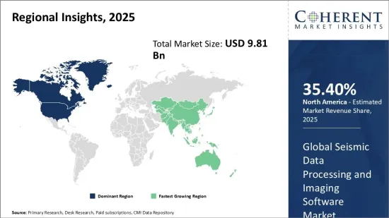
2025 年全球地震資料處理和影像軟體市場規模估計為 98.1 億美元,預計到 2032 年將達到 206.3 億美元,2025 年至 2032 年的年複合成長率(CAGR)為 11.2%。
| 報告範圍 | 報告詳細資訊 | ||
|---|---|---|---|
| 基準年 | 2024 | 2025年的市場規模 | 98.1億美元 |
| 效能數據 | 從2020年到2024年 | 預測期 | 2025年至2032年 |
| 預測期:2025-2032年複合年成長率: | 11.20% | 2032年價值預測 | 206.3億美元 |
地震資料處理和成像軟體可協助石油、天然氣和採礦等行業探測和分析潛在的地下礦床位置。這涉及收集、處理和解釋地震數據,以繪製可能包含寶貴資源的地下結構圖。該軟體能夠創建地下地層的 2D 和 3D 視覺化效果。採用先進的演算法和地球物理技術來消除原始地震測量中的雜訊並提高訊號解析度。這使得我們能夠更準確地檢測和描述地質結構和有趣的特徵,例如斷層、褶皺和碳氫化合物儲存。這些解決方案中整合的解釋和視覺化工具可協助專業人員就探勘活動和資源提取計劃做出明智的決策。
市場動態:
隨著易於開採的石油和天然氣礦床蘊藏量枯竭,對先進探勘技術的需求不斷增加,推動了全球地震資料處理和成像軟體市場的發展。從超深水、北極和頁岩層開採資源的複雜性日益增加,推動了對高解析度地震探勘的依賴。這推動了對先進處理和成像解決方案的需求。然而,地震勘測和軟體許可相關的高成本可能會阻礙市場成長。正在進行的雲端基礎的解決方案和服務開發研究可以透過降低探勘公司的資本成本來創造機會。機器學習和人工智慧等技術的融合是另一個獲得支援以提供更準確探勘結果的主要趨勢。
本研究的主要特點
本報告對全球地震資料處理和成像軟體市場進行了詳細分析,並以 2024 年為基準年,展示了預測期(2025-2032 年)的市場規模和複合年成長率。
它還強調了各個領域的潛在商機,並說明了該市場的有吸引力的投資提案矩陣。
它還提供了有關市場促進因素、限制因素、機會、新產品發布和核准、市場趨勢、區域前景和主要企業採用的競爭策略的重要見解。
全球地震資料處理和成像軟體市場的主要企業根據公司亮點、產品系列、關鍵亮點、性能和策略等參數進行分析。
研究涉及的主要企業包括哈里伯頓、CGG、SLB(斯倫貝謝有限公司)、Equinor ASA、Fugro、Shearwater GeoServices、DUG Technology、TGS-NOPEC Geophysical、AspenTech、GLOBEClaritas、Golden Software、gINT、Petrel E&P、OpendTect 和 SeisEarth。
本報告的見解將使負責人和公司經營團隊能夠就未來的產品發布、類型升級、市場擴張和行銷策略做出明智的決策。
全球地震資料處理和成像軟體市場報告迎合了該行業的各個相關人員,例如投資者、供應商、產品製造商、經銷商、新進業者和金融分析師。
相關人員可以透過用於分析全球地震資料處理和成像軟體市場的各種策略矩陣來更輕鬆地做出決策。
目錄
第1章 調查目的與前提條件
- 研究目標
- 先決條件
- 簡稱
第2章 市場展望
- 報告描述
- 市場定義和範圍
- 執行摘要
第3章市場動態、法規與趨勢分析
- 市場動態
- 影響分析
- 主要亮點
- 監管情景
- 產品發布/核准
- PEST分析
- 波特分析
- 市場機會
- 監管情景
- 主要進展
- 產業趨勢
4. 2020 年至 2032 年全球地震資料處理與影像軟體市場(依技術分類)
- 3D成像
- 2D成像
- 4D成像
5. 2020 年至 2032 年全球地震資料處理與影像軟體市場(按地區)
- 陸上
- 海上
6. 2020 年至 2032 年全球地震資料處理與影像軟體市場(按地區)
- 北美洲
- 拉丁美洲
- 歐洲
- 亞太地區
- 中東
- 非洲
第7章競爭格局
- Halliburton
- CGG
- SLB(Schlumberger Limited)
- Equinor ASA
- Fugro
- Shearwater GeoServices
- DUG Technology
- TGS-NOPEC Geophysical
- AspenTech
- GLOBEClaritas
- Golden Software
- gINT
- Petrel E&P
- OpendTect
- SeisEarth
第 8 章分析師建議
- 命運之輪
- 分析師觀點
- 一致的機會圖
第9章參考文獻與調查方法
- 參考
- 調查方法
- 關於出版商
Global Seismic Data Processing and Imaging Software Market is estimated to be valued at US$ 9.81 Bn in 2025 and is expected to reach US$ 20.63 Bn by 2032, growing at a compound annual growth rate (CAGR) of 11.2% from 2025 to 2032.
| Report Coverage | Report Details | ||
|---|---|---|---|
| Base Year: | 2024 | Market Size in 2025: | USD 9.81 Bn |
| Historical Data for: | 2020 To 2024 | Forecast Period: | 2025 To 2032 |
| Forecast Period 2025 to 2032 CAGR: | 11.20% | 2032 Value Projection: | USD 20.63 Bn |
Seismic data processing and imaging software helps organizations operating in industries like oil & gas and mining detect and analyze potential deposit sites underground. It involves collecting, processing, and interpreting seismic wave data to map subsurface structures that could contain valuable resources. The software allows creating 2D and 3D visualizations of underground formations. It applies advanced algorithms and geophysical techniques to remove noise and enhance signal resolution in raw seismic measurements. This aids in more precise detection and delineation of geological structures and features of interest like faults, folds, hydrocarbon reservoirs, etc. Integrated interpretation and visualization tools in these solutions help experts make well-informed decisions about exploration activities and resource extraction plans.
Market Dynamics:
The global seismic data processing and imaging software market is driven by the rising need for advanced exploration technologies amid depleting reserves of easily accessible oil and gas deposits. Growing complexities in extracting resources from ultra-deepwater, arctic regions and shale formations have increased dependence on high-resolution seismic surveys. This is propelling the demand for sophisticated processing and imaging solutions. However, high costs associated with seismic surveys and software licensing may hinder the market growth. Ongoing research towards developing cloud-based solutions and services could create opportunities by reducing capital expenses for exploration companies. Integration of technologies like machine learning and artificial intelligence is another key trend gaining traction to deliver more accurate seismic results.
Key Features of the Study:
This report provides in-depth analysis of the global seismic data processing and imaging software market, and provides market size (US$ Billion) and compound annual growth rate (CAGR%) for the forecast period (2025-2032), considering 2024 as the base year
It elucidates potential revenue opportunities across different segments and explains attractive investment proposition matrices for this market
This study also provides key insights about market drivers, restraints, opportunities, new product launches or approvals, market trends, regional outlook, and competitive strategies adopted by key players
It profiles key players in the global seismic data processing and imaging software market based on the following parameters - company highlights, products portfolio, key highlights, financial performance, and strategies
Key companies covered as a part of this study include Halliburton, CGG, SLB (Schlumberger Limited), Equinor ASA, Fugro, Shearwater GeoServices, DUG Technology, TGS-NOPEC Geophysical, AspenTech, GLOBEClaritas, Golden Software, gINT, Petrel E&P, OpendTect, and SeisEarth
Insights from this report would allow marketers and the management authorities of the companies to make informed decisions regarding their future product launches, type up-gradation, market expansion, and marketing tactics
The global seismic data processing and imaging software market report caters to various stakeholders in this industry including investors, suppliers, product manufacturers, distributors, new entrants, and financial analysts
Stakeholders would have ease in decision-making through various strategy matrices used in analyzing the global seismic data processing and imaging software market
Market Segmentation
- Technology Insights (Revenue, USD Bn, 2020 - 2032)
- 3D Imaging
- 2D Imaging
- 4D Imaging
- Location Insights (Revenue, USD Bn, 2020 - 2032)
- Onshore
- Offshore
- Regional Insights (Revenue, USD Bn, 2020 - 2032)
- North America
- U.S.
- Canada
- Latin America
- Brazil
- Argentina
- Mexico
- Rest of Latin America
- Europe
- Germany
- U.K.
- Spain
- France
- Italy
- Russia
- Rest of Europe
- Asia Pacific
- China
- India
- Japan
- Australia
- South Korea
- ASEAN
- Rest of Asia Pacific
- Middle East
- GCC Countries
- Israel
- Rest of Middle East
- Africa
- South Africa
- North Africa
- Central Africa
- Key Players Insights
- Halliburton
- CGG
- SLB (Schlumberger Limited)
- Equinor ASA
- Fugro
- Shearwater GeoServices
- DUG Technology
- TGS-NOPEC Geophysical
- AspenTech
- GLOBEClaritas
- Golden Software
- gINT
- Petrel E&P
- OpendTect
- SeisEarth
Table of Contents
1. Research Objectives and Assumptions
- Research Objectives
- Assumptions
- Abbreviations
2. Market Purview
- Report Description
- Market Definition and Scope
- Executive Summary
- Global Seismic Data Processing and Imaging Software Market, By Technology
- Global Seismic Data Processing and Imaging Software Market, By Location
- Global Seismic Data Processing and Imaging Software Market, By Region
3. Market Dynamics, Regulations, and Trends Analysis
- Market Dynamics
- Impact Analysis
- Key Highlights
- Regulatory Scenario
- Product Launches/Approvals
- PEST Analysis
- PORTER's Analysis
- Market Opportunities
- Regulatory Scenario
- Key Developments
- Industry Trends
4. Global Seismic Data Processing and Imaging Software Market, By Technology, 2020-2032, (USD Bn)
- Introduction
- Market Share Analysis, 2025 and 2032 (%)
- Y-o-Y Growth Analysis, 2021 - 2032
- Segment Trends
- 3D Imaging
- Introduction
- Market Size and Forecast, and Y-o-Y Growth, 2020-2032, (USD Bn)
- 2D Imaging
- Introduction
- Market Size and Forecast, and Y-o-Y Growth, 2020-2032, (USD Bn)
- 4D Imaging
- Introduction
- Market Size and Forecast, and Y-o-Y Growth, 2020-2032, (USD Bn)
5. Global Seismic Data Processing and Imaging Software Market, By Location, 2020-2032, (USD Bn)
- Introduction
- Market Share Analysis, 2025 and 2032 (%)
- Y-o-Y Growth Analysis, 2021 - 2032
- Segment Trends
- Onshore
- Introduction
- Market Size and Forecast, and Y-o-Y Growth, 2020-2032, (USD Bn)
- Offshore
- Introduction
- Market Size and Forecast, and Y-o-Y Growth, 2020-2032, (USD Bn)
6. Global Seismic Data Processing and Imaging Software Market, By Region, 2020 - 2032, Value (USD Bn)
- Introduction
- Market Share (%) Analysis, 2025,2028 & 2032, Value (USD Bn)
- Market Y-o-Y Growth Analysis (%), 2021 - 2032, Value (USD Bn)
- Regional Trends
- North America
- Introduction
- Market Size and Forecast, By Technology, 2020 - 2032, Value (USD Bn)
- Market Size and Forecast, By Location, 2020 - 2032, Value (USD Bn)
- Market Size and Forecast, By Country, 2020 - 2032, Value (USD Bn)
- U.S.
- Canada
- Latin America
- Introduction
- Market Size and Forecast, By Technology, 2020 - 2032, Value (USD Bn)
- Market Size and Forecast, By Location, 2020 - 2032, Value (USD Bn)
- Market Size and Forecast, By Country, 2020 - 2032, Value (USD Bn)
- Brazil
- Argentina
- Mexico
- Rest of Latin America
- Europe
- Introduction
- Market Size and Forecast, By Technology, 2020 - 2032, Value (USD Bn)
- Market Size and Forecast, By Location, 2020 - 2032, Value (USD Bn)
- Market Size and Forecast, By Country, 2020 - 2032, Value (USD Bn)
- Germany
- K.
- Spain
- France
- Italy
- Russia
- Rest of Europe
- Asia Pacific
- Introduction
- Market Size and Forecast, By Technology, 2020 - 2032, Value (USD Bn)
- Market Size and Forecast, By Location, 2020 - 2032, Value (USD Bn)
- Market Size and Forecast, By Country, 2020 - 2032, Value (USD Bn)
- China
- India
- Japan
- Australia
- South Korea
- ASEAN
- Rest of Asia Pacific
- Middle East
- Introduction
- Market Size and Forecast, By Technology, 2020 - 2032, Value (USD Bn)
- Market Size and Forecast, By Location, 2020 - 2032, Value (USD Bn)
- Market Size and Forecast, By Country, 2020 - 2032, Value (USD Bn)
- GCC Countries
- Israel
- Rest of Middle East
- Africa
- Introduction
- Market Size and Forecast, By Technology, 2020 - 2032, Value (USD Bn)
- Market Size and Forecast, By Location, 2020 - 2032, Value (USD Bn)
- Market Size and Forecast, By Country/Region, 2020 - 2032, Value (USD Bn)
- South Africa
- North Africa
- Central Africa
7. Competitive Landscape
- Halliburton
- Company Highlights
- Product Portfolio
- Key Developments
- Financial Performance
- Strategies
- CGG
- Company Highlights
- Product Portfolio
- Key Developments
- Financial Performance
- Strategies
- SLB (Schlumberger Limited)
- Company Highlights
- Product Portfolio
- Key Developments
- Financial Performance
- Strategies
- Equinor ASA
- Company Highlights
- Product Portfolio
- Key Developments
- Financial Performance
- Strategies
- Fugro
- Company Highlights
- Product Portfolio
- Key Developments
- Financial Performance
- Strategies
- Shearwater GeoServices
- Company Highlights
- Product Portfolio
- Key Developments
- Financial Performance
- Strategies
- DUG Technology
- Company Highlights
- Product Portfolio
- Key Developments
- Financial Performance
- Strategies
- TGS-NOPEC Geophysical
- Company Highlights
- Product Portfolio
- Key Developments
- Financial Performance
- Strategies
- AspenTech
- Company Highlights
- Product Portfolio
- Key Developments
- Financial Performance
- Strategies
- GLOBEClaritas
- Golden Software
- gINT
- Petrel E&P
- OpendTect
- SeisEarth
8. Analyst Recommendations
- Wheel of Fortune
- Analyst View
- Coherent Opportunity Map
9. References and Research Methodology
- References
- Research Methodology
- About us
 2026-2030年全球視覺處理單元市場
 視覺處理單元市場:依架構、核心數量、運作頻率、記憶體介面、應用、最終用戶和通路分類-2026-2032年全球市場預測
 2026年全球視覺處理單元市場報告2026年全球影像處理系統市場報告
 視覺處理單元市場 - 全球產業規模、佔有率、趨勢、機會、預測:按類型、最終用戶、地區和競爭格局分類,2021-2031年地震探勘軟體市場:依軟體功能、授權模式、資料類型、部署模式、應用領域及最終用戶產業分類-2026年至2032年全球預測影像擷取與處理軟體市場:2026-2032年全球預測(按組件、應用、部署類型和公司規模分類)
 視覺處理單元市場規模、佔有率和成長分析(按製造流程、應用、產業垂直領域和地區分類)-2026-2033年產業預測
 全球視覺處理單元 (VPU) 市場規模(按架構、應用、最終用戶產業、地區、範圍和預測)
 視覺處理單元 (VPU) 市場規模、佔有率和趨勢分析報告:2024-2030 年按製造流程、應用、產業、地區和細分市場進行的預測